Lihou: tidal island, priory ruins and conservation site off Guernsey
Lihou is a small tidal island off Guernsey in the Channel Islands, accessible at low tide by an ancient causeway. It is noted for its priory ruins, intertidal habitats and managed conservation and education programmes.
Overview
Lihou is a small tidal island off the west coast of Guernsey in the Bailiwick of Guernsey, Channel Islands. It lies within the Parish of St. Peter's and is often described as the most westerly point of the Channel Islands. The island's area is traditionally given as 95 vergées (about 38½ acres or 15.6 hectares), and its shore and surrounding sea support a variety of wildlife and historical remains. Ownership and long‑term management are the responsibility of the island authorities, who acquired Lihou in the late 20th century and now balance public access with conservation objectives (ownership and management, area notes, metric conversion).
Image gallery
9 Images


Geography and access
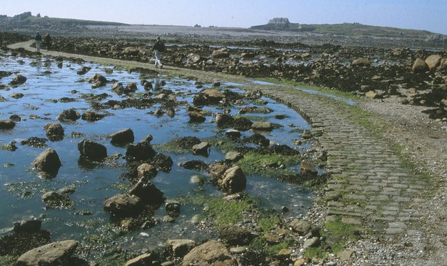
Lihou sits close to L'Eree headland and is connected to Guernsey by an ancient stone causeway that is passable only at low tide. Because the causeway is submerged at high water, visitors must plan crossings carefully and follow local tide timetables and guidance provided on site. The tidal conditions create a mosaic of intertidal habitats — rocky ledges, boulder fields, sandy areas and rock pools — that change visibly with each tidal cycle and provide important feeding and nursery areas for coastal species. For practical guidance on crossing and safety see local advice (causeway and crossing guidance) and the general information on Guernsey geography (Guernsey and local geography).
History and built features
Visible on the island are the remains of historic occupation, most notably the ruins traditionally described as a medieval priory or monastic building, together with later agricultural structures and walls. Over many centuries Lihou has been used intermittently for religious purposes, grazing and small-scale maritime activity. The surviving stonework and the layout of enclosures have attracted archaeological interest and conservation attention; further detail and heritage interpretation are available through local heritage resources (historic structures and archaeology).
Ecology and conservation
Lihou is valued for its birdlife, marine communities and intertidal ecosystems. Waders, gulls and other coastal birds use the shores for feeding and resting, while rock pools and seaweed beds host a wide range of invertebrates and small fishes. The surrounding waters occasionally attract seals and diversified fish life, and seasonal movements of seabirds make the island a useful monitoring site. Management of Lihou emphasises habitat protection, careful visitor access and education; the island is used for school visits, volunteer work parties and systematic surveys that inform conservation measures (Bailiwick conservation links, Channel Islands context).
Visiting Lihou
Visitors come to Lihou to see the ruins, explore the shore and observe wildlife. Important practical points: check tide times before crossing, wear appropriate footwear for rocky and muddy ground, respect nesting birds and sensitive habitats, and adhere to guidance given by on‑site notices or managing authorities. Information on access, events and permitted activities is published by the island administration and associated heritage organisations (management information, crossing guidance).
Management, research and further information
The island is managed to balance public use, heritage conservation and ecological protection. Ongoing work typically includes habitat monitoring, maintenance of paths and the causeway approaches, archaeological recording of the ruins and educational outreach. For authoritative and up‑to‑date detail consult official and heritage resources listed by the local authorities and conservation partners (archaeology and heritage, local geography overview, area and measurement notes, metric details, broader island context, government information).
Related articles
Author
AlegsaOnline.com Lihou: tidal island, priory ruins and conservation site off Guernsey Leandro Alegsa
URL: https://en.alegsaonline.com/art/57992
Sources
- commons.wikimedia.org : Lihou