Channel Islands: geography, history, governance and culture
The Channel Islands are a group of islands in the English Channel near the coast of France. They have distinct jurisdictions, unique cultures, and notable history including German occupation during WWII.
Overview
The Channel Islands are an archipelago in the English Channel located close to the coast of France. Although geographically nearer to France than to Great Britain, they are not part of the United Kingdom; instead they are self-governing Crown dependencies with close constitutional links to the British Crown. The islands are best known for their mix of British and Norman influences, coastal scenery, and a history that has shaped their institutions and identity.
Image gallery
10 Images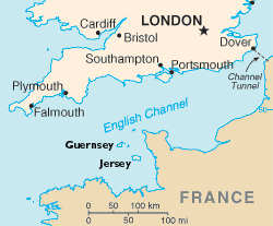


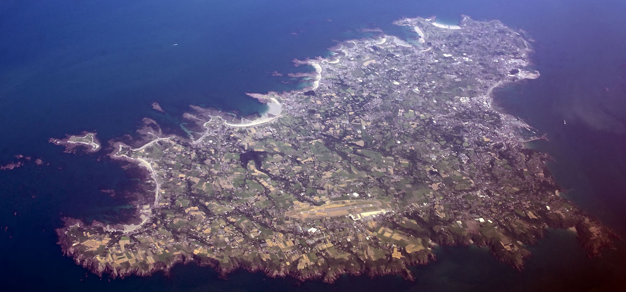

Major islands and geography
The group includes several inhabited and uninhabited islands. The five largest and most commonly referenced are:
- Jersey
- Guernsey
- Alderney
- Sark
- Herm
The terrain ranges from low cliffs and rocky headlands to sheltered bays and sand beaches. Tidal ranges around some of the islands are large, exposing wide intertidal zones that support diverse marine life and attract visitors interested in coastline exploration.
History and development
Human presence on the islands extends back to prehistoric times and their strategic position has meant they played roles in maritime trade and defence. The islands were historically tied to the Duchy of Normandy and retained particular law forms and customs after Normandy was separated from the English Crown. A defining modern event was the German occupation during the Second World War, the only part of the British Isles to be occupied; remnants of that period remain visible in fortifications and local memory.
Governance, law and economy
Each main island or grouping has its own political institutions and legal system. Jersey and the Bailiwick of Guernsey (which includes Alderney, Sark and smaller islets) handle most domestic affairs while the United Kingdom remains responsible for defence and international representation. Economically, tourism, agriculture, fisheries and financial services are important. The islands have developed reputations for offshore finance, yet also emphasize conservation and sustainable use of natural resources.
Culture, language and travel
Cultural life blends British and Norman traditions. English is widely spoken and used in government, but local Norman dialects such as Jèrriais and Guernésiais persist in signage, literature and revival efforts. Visitors reach the islands by ferry or air; travel and hospitality services are geared to seasonal tourism, heritage visits and outdoor activities like walking, birdwatching and sailing.
Notable facts and distinctions
The Channel Islands occupy a distinctive legal and constitutional niche: they are Crown dependencies rather than overseas territories, have separate tax and regulatory regimes, and maintain local customs and laws derived from Norman tradition. Their proximity to the French coast is close enough that visitors sometimes combine island visits with travel in Normandy; see general information about the Channel Islands and the nearby coast of France for regional context.
Admin
Politically, they are divided into the bailiwicks of Guernsey and Jersey. The two bailiwicks have their own parliaments, the States.
As a remnant of the historic Duchy of Normandy, whose mainland territory now belongs to France, the Channel Islands are neither part of the United Kingdom nor a crown colony, but are directly subject to the British Crown (in its function as Dukes of Normandy) as a crown dependency (→ Suzerainty). Only the Isle of Man has this special status.
Although the Channel Islands are not geographically part of the British Isles, they are often included for political reasons. When Great Britain joined the European Community in 1973, the status of the Channel Islands was regulated in an additional protocol. Accordingly, the Channel Islands were not members of the EU, but were part of its customs territory.
With more than 100 financial institutions and 352 insurance companies (as of 2008), the Channel Islands are a major financial centre and are still considered an attractive tax haven.
Islands
f1![]() Map with all coordinates: OSM | WikiMap
Map with all coordinates: OSM | WikiMap
Bailiwick of Jersey
| Island | surface km² | Inhabitants | Coordinates |
| 119,6 | 100.800 | 49° 13′ 0″ N, 2° 7′ 57″ W | |
| Les Dirouilles | < 1 | uninhabited | 49° 19′ 30″ N, 2° 2′ 30″ W |
| Ecréhous | < 1 | uninhabited | 49° 17′ 30″ N, 1° 55′ 30″ W |
| Minquiers | < 1 | uninhabited | 48° 58′ 30″ N, 2° 7′ 30″ W |
| Pierres de Lecq | < 1 | uninhabited | 49° 17′ 30″ N, 2° 12′ 10″ W |
Bailiwick of Guernsey
| Island | surface km² | Inhabitants | Coordinates |
| 63,4 | 62.533 | 49° 27′ 21″ N, 2° 34′ 39″ W | |
| 7,8 | 2020 | 49° 42′ 0″ N, 2° 12′ 0″ W | |
| 5,5 | 492 | 49° 26′ 0″ N, 2° 22′ 0″ W | |
| 2 | 79 | 49° 28′ 22″ N, 2° 26′ 58″ W | |
| 0,6 | 2 | 49° 25′ 53″ N, 2° 23′ 14″ W | |
| 0,13 | uninhabited | 49° 43′ 53″ N, 2° 15′ 7″ W | |
| 0,18 | 3 | 49° 27′ 28″ N, 2° 27′ 45″ W | |
| 0,156 | uninhabited | 49° 27′ 38″ N, 2° 40′ 6″ W | |
| 0,03 | uninhabited | 49° 43′ 4″ N, 2° 22′ 7″ W |
- ↑ a b c d e Group of reefs and cliffs
- ↑ Jethou included
- ↑ Tidal Island
Related articles
Author
AlegsaOnline.com Channel Islands: geography, history, governance and culture Leandro Alegsa
URL: https://en.alegsaonline.com/art/18568