Kabul River
The Kabul River is a major transboundary tributary of the Indus, rising in Afghanistan's Sanglakh Range and flowing about 700 km through Kabul and Jalalabad into Pakistan, supporting irrigation, hydropower and trade routes.
The Kabul River (Persian: دریای کابل) is a principal river of eastern Afghanistan and an important transboundary tributary of the Indus River. It rises in the Sanglakh Range in central Afghanistan and runs roughly 700 km eastward, passing through the city of Afghanistan's capital, Kabul, then through the Jalalabad plain before entering Pakistan and joining the Indus near Attock. The river has long influenced settlement, agriculture and communications between the highlands and the Indus plain.
Image gallery
8 Images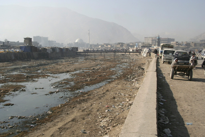


Course and tributaries
From its headwaters the Kabul River drains a basin fed by snowmelt, springs and seasonal rains. On its route it receives inflow from several significant tributaries, notably the Logar, Panjshir, Kunar (in parts also associated with the Chitral region), Alingar and Bara rivers. These tributaries swell the Kabul during spring melt and the summer monsoon, affecting downstream flow regimes and flood risk. The river crosses the modern international frontier some distance north of the Khyber Pass and continues through Pakistani districts where it supports agricultural plains and urban centres.
Uses, infrastructure and management
The Kabul River basin supports irrigation networks, urban water supply and hydropower installations. In Pakistan, the Warsak hydro facility and related irrigation works regulate flows for downstream use and generation of electricity. Elsewhere along its course small and medium dams, diversion channels and canals have been built to support cropping and local needs. Managing the river requires coordination of seasonal water releases, sediment control and maintenance of irrigation infrastructure across administrative boundaries.
History and regional importance
The Kabul River valley has been an important corridor linking Central Asia and South Asia for millennia. Fertile floodplains and accessible riverine routes fostered settlements and trade, and the basin falls within cultural regions historically connected to Gandhara and other ancient social networks. The river's name is borne by the city of Kabul, which developed along its banks and relied on its waters for agriculture and local industry.
Environmental concerns
Contemporary challenges include seasonal flooding, riverbank erosion, increasing sediment loads and water quality deterioration near urban centres. Pollution from untreated sewage, industrial discharges and agricultural runoff has been reported in populated stretches. Climate variability affecting snowmelt and rainfall patterns, together with rising demand from growing populations and expanded irrigation, create pressure on both quantity and quality of water.
- Approximate length: about 700 km; meets the Indus near Attock.
- Principal cities on its course include Kabul, Jalalabad and Nowshera.
- Main tributaries: Logar, Panjshir, Kunar, Alingar and Bara rivers.
- Crosses into Pakistan north of the Khyber Pass region.
Effective stewardship of the Kabul River requires regional cooperation, investment in pollution control and infrastructure maintenance, and adaptive planning to cope with seasonal variability. Researchers and water-resource programs continue to study its hydrology, flood patterns and the social impacts of water management in both Afghanistan and Pakistan.
Related articles
Author
AlegsaOnline.com Kabul River Leandro Alegsa
URL: https://en.alegsaonline.com/art/51850