Geography of the Dominican Republic
Physical and human geography of the Dominican Republic: location, landforms, climate zones, rivers and islands, borders with Haiti, and notable geographic features and distinctions.
Overview
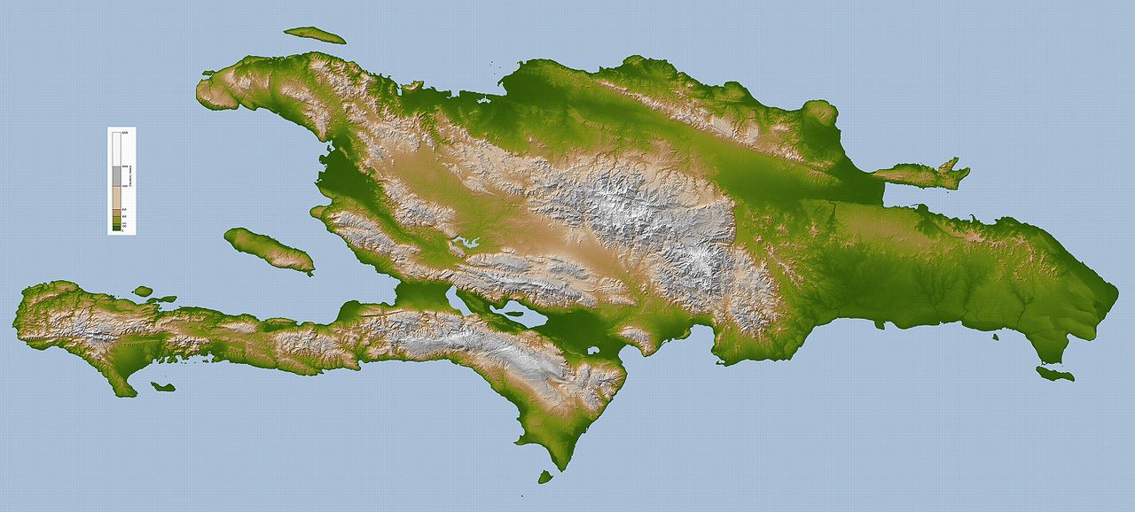
The Dominican Republic (República Dominicana) occupies the eastern portion of the island of Hispaniola in the Caribbean. It shares a land border to the west with Haiti, a frontier roughly 388 km long, and is bounded by the Atlantic Ocean to the north and the Caribbean Sea to the south. The country's total area is about 48,671 km², including the main portion on Hispaniola and a number of smaller offshore islets.
Image gallery
10 Images


Topography and major landforms
The Dominican landscape is varied: coastal plains give way to rolling hills and a range of rugged mountains. The dominant highland is the Cordillera Central, which contains Pico Duarte, the highest peak in the Caribbean. Parallel to it are other ranges such as the Sierra de Neiba and the Sierra de Bahoruco. Between these mountains lie fertile valleys and basins that host most of the country's agricultural production.
- Highest point: Pico Duarte (Cordillera Central)
- Notable lowland: Lake Enriquillo, a hypersaline lake in the southwest, is one of the region's lowest surface points
- Coastal features: extensive beaches, coral reefs, and barrier beaches on both the Atlantic and Caribbean coasts
Rivers, drainage and islands
Rivers in the country flow either north toward the Atlantic or south into the Caribbean Sea. Major rivers include the Yaque del Norte, Yuna and Yaque del Sur; many are used for irrigation and hydroelectric power. Offshore, the Dominican Republic administers several well-known islands and cays such as Saona, Catalina and Beata, which are frequented for tourism and marine biodiversity.
Climate and ecosystems
The climate is tropical, but it varies with elevation and exposure to trade winds. Coastal lowlands tend to be hot and humid, while higher elevations are cooler and may receive greater rainfall. The island supports a range of ecosystems — from dry scrub and thorn forests in rain-shadow zones to moist broadleaf forests and cloud forests at altitude — and hosts important endemic species. Seasonal patterns are shaped by a wet season and a drier season, and the region is affected by tropical storms and hurricanes during part of the year.
Human geography and administration
The capital, Santo Domingo, is located on the south coast and is one of the oldest continuously inhabited European-established cities in the Americas. Population and economic activity are concentrated in coastal plains and in major valleys where agriculture and urban development are easier. The national territory is divided into provinces and municipalities that reflect both geographic regions and historical settlement patterns.
Borders, distances and strategic location
To the west the Dominican Republic shares the island with Haiti, while to the southeast the island group lies across the Mona Channel from Puerto Rico (a separation of about 130 km). The country's maximum east–west extent is roughly 390 km and its maximum north–south span about 265 km, measurements that underscore both its sizeable land area for a Caribbean state and its strategic position between two major bodies of water.
Importance and notable distinctions
Geographically, the Dominican Republic stands out for its combination of mountain topography, productive agricultural valleys, and extensive coastal resources that support tourism, fisheries and port activity. Physical contrasts — from Pico Duarte to Lake Enriquillo — contribute to the island's ecological diversity and to regional differences in climate, land use and settlement. For further general reference, see regional maps and country summaries linked below.
References and external resources: Hispaniola overview, Atlantic settings, Caribbean context, national profile, Caribbean region.
Questions and answers
Q: What is the Dominican Republic?
A: The Dominican Republic is a country located in the Caribbean.
Q: What is the size of the Dominican Republic?
A: The country has a total area of 48,671 km².
Q: What part of Hispaniola does the Dominican Republic occupy?
A: The Dominican Republic occupies the eastern five-eighths of Hispaniola.
Q: What is the land border between the Dominican Republic and Haiti?
A: The land border between the two countries is 388 km long.
Q: What is the capital of the Dominican Republic?
A: The capital of the Dominican Republic is Santo Domingo.
Q: What are the limits of the Dominican Republic?
A: The limits of the country are Haiti to the west, the Atlantic Ocean to the north, and the Caribbean Sea to the south.
Q: What separates the Dominican Republic from Puerto Rico?
A: Puerto Rico is separated from the Dominican Republic by the Mona Channel, which is about 130 km wide.
Related articles
Author
AlegsaOnline.com Geography of the Dominican Republic Leandro Alegsa
URL: https://en.alegsaonline.com/art/38135
Sources
- books.google.com : "Vascular Surgery: A Global Perspective"
- books.google.com : "Current Affairs November 2016 eBook"
- britannica.com : "Hispaniola Article"
- cardiostart.org : "Dominican Republic 2014"
- caribjsci.org : "The Highest Mountain in the Caribbean: Controversy and Resolution via GPS"