Chongqing (municipality) — major city and municipality in southwestern China
Chongqing is a major Chinese municipality on the Yangtze River known for its large population, mountainous terrain, industrial economy, spicy cuisine and historical sites including Dazu Rock Carvings.
Chongqing (Simplified Chinese: 重庆; pinyin: Chóngqìng; historic romanization: Chungking) is a major city and one of China's four centrally administered municipalities. Located where the Yangtze and Jialing rivers meet in southwestern China, Chongqing combines a dense urban core with an extensive surrounding territory, making it one of the country's largest municipalities by area and population.
Image gallery
10 Images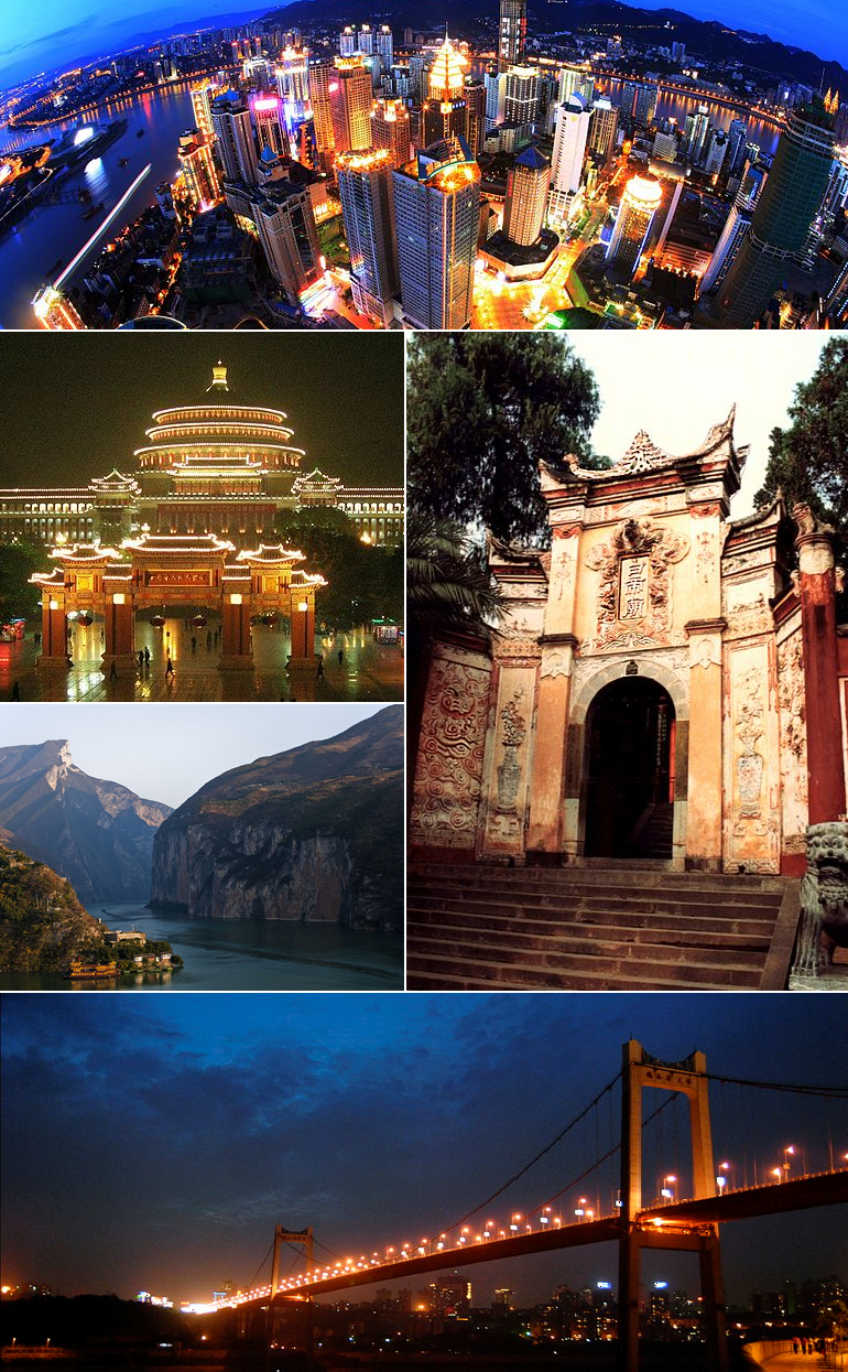


Geography and administration
The municipality covers a vast, mostly mountainous area characterized by steep hills, river gorges and a humid subtropical climate with hot summers and mild winters. Administratively, Chongqing governs multiple urban districts and outlying counties; this structure leads to a distinction between the compact city proper and the wider municipal region that includes rural towns and farmland.
History and development
Chongqing has a long history as a regional commercial and transport hub. It gained national prominence in the 20th century when it served as the wartime provisional capital of the Republic of China during the Second Sino-Japanese War. In 1997 the Chinese government elevated Chongqing to the status of a directly controlled municipality to accelerate regional development along the upper Yangtze.
Economy and transport
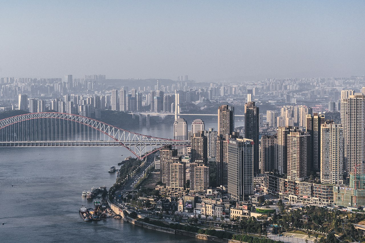
The municipality is an industrial and logistics center, with significant automotive, machinery, chemical and electronics industries and a busy inland port on the Yangtze River. Extensive road, rail and river networks link Chongqing to western and central China; notable urban infrastructure includes bridges spanning deep valleys and a monorail system adapted to hilly terrain.
Culture, cuisine and tourism
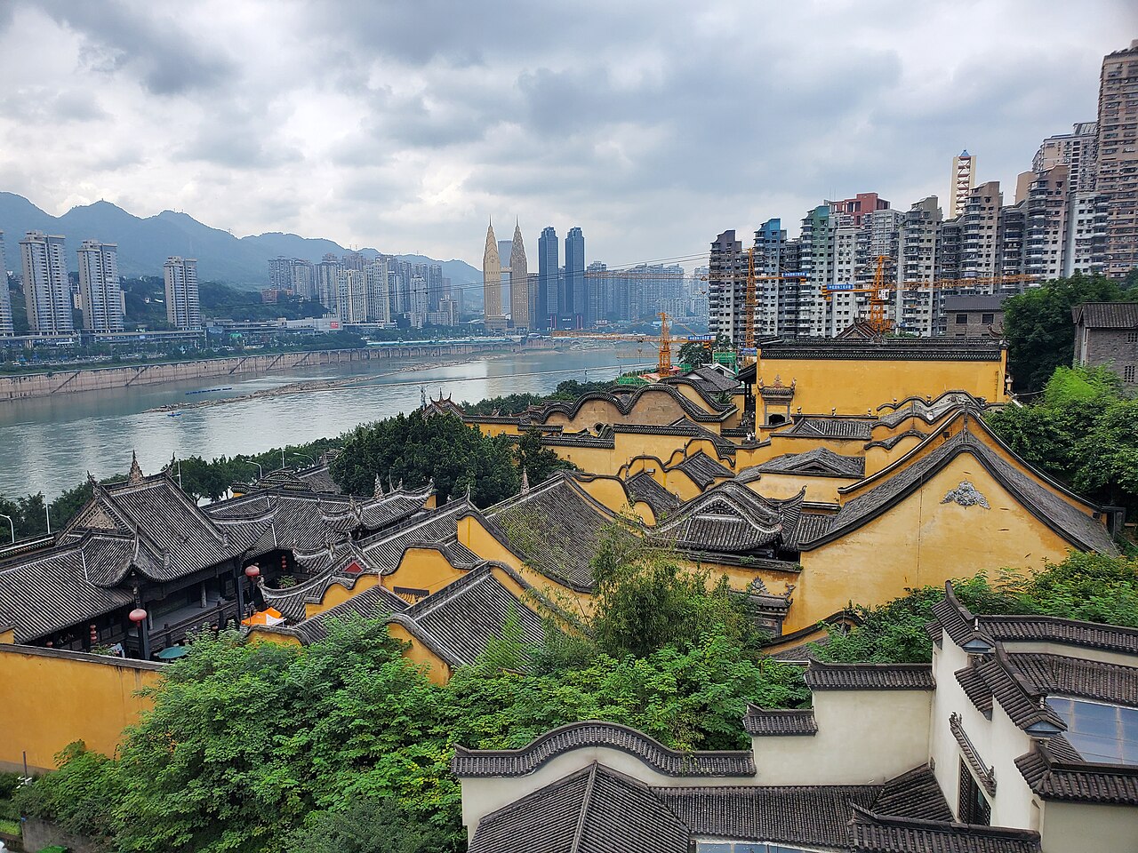
Chongqing is widely known for its fiery cuisine, especially the Chongqing hotpot and pepper-forward dishes that reflect Sichuan culinary influences. Cultural landmarks and tourist attractions include ancient towns, riverfront promenades and several protected sites:
- Dazu Rock Carvings — a series of religious stone carvings recognized for their historical and artistic value.
- Wulong Karst and other scenic karst landscapes and gorges.
- Historic districts such as Ciqikou and mountain vistas along the Yangtze.
For municipal information or statistics see official references. Chongqing's combination of urban dynamism, rugged topography and cultural heritage makes it a distinctive and strategically important city in modern China.
Geography
Geographical position
The city of Chongqing was built at the confluence of the Jialing River and the Yangtze River. Its location on the eastern edge of the Red Basin, the "rice bowl" of China, has favoured the city's growth. However, its great distance from the coast and especially its difficult accessibility have hindered development in the past. The reservoir formed by the Three Gorges Dam extends to Chongqing, allowing larger ships to reach the city.
The city is surrounded by mountains: the Daba Shan in the north, the Wu Shan in the east and the Dalou Shan in the south. Since Chongqing was built on very hilly terrain, some of the streets are very steep, which is expressed in the name "City of Mountains" (Shancheng). It lies on average 243 meters above sea level.
The administrative urban area of Chongqing stretches 470 kilometres in an east-west direction and 450 kilometres in a north-south direction. It has an area of 82,402.95 square kilometers, which is roughly equivalent to the land area of Austria. Of this area, 1,472.55 square kilometres (1.79%) belong to the core city (high building density and enclosed village form) and 80,930.4 square kilometres (98.21%) to areas with a predominantly rural settlement structure. The metropolitan region has an area of 9,622.83 square kilometres.
Neighboring provinces are Hubei and Hunan in the east, Guizhou in the south, Sichuan in the west and Shaanxi in the north. About 80 rivers flow through the administrative area of the government-unified city of Chongqing. The largest are the Yangtze, the Jialing, the Wu Jiang, the Fu Jiang, the Qi Jiang and the Daning He.
Geology
Chongqing is located in the Red Basin, a basin landscape traversed by the Yangtze River and fertile rolling hills of predominantly red sandstones and clays, enclosed all around by higher mountain ranges. The Red Basin is rich in mineral resources (coal deposits, ores, salt, petroleum and phosphorus). Chongqing hit the headlines due to the Chuandongbei gas explosion on December 25, 2003, when a large amount of toxic gas suddenly escaped after an explosion of a gas well on the Chuandongbei gas field, killing 191 people and injuring an estimated 4000 to 5000 people, some of them seriously.
To the northwest of the basin lies the Chengdu alluvial plain. The Yangtze River, about 6380 kilometres long and rich in rapids, breaks through the mountain ranges that have bulged up at the Chinese Relay Fault and seal off the Red Basin from east-central China.

City structure and population
Downtown
Downtown Chongqing is divided into six districts. These are:
- Yuzhong Municipality (渝中区, Yuzhong Qū), the downtown area proper.
- Dadukou Municipality (大渡口区, Dàdukou Qū),
- Nan'an Municipality (南岸区, Nán'ān Qū),
- Jiulongpo Municipality (九龙坡区, Jiǔlóngpo Qū),
- Shapingba Municipality (沙坪坝区, Shapingba Qū),
- Jiangbei Municipality (江北区, Jiāngběi Qū).
The so-called "New Municipality" of Liangjiang (两江新区, Liǎngjiāng Xīnqū), established on 18 June 2010, comprises parts of the municipalities of Jiangbei, Yubei and Beibei with a total area of approximately 1,200 km². Unlike comparable new establishments in Tianjin (Binhai) and Shanghai (Pudong), this is purely a measure to promote economic development, i.e. Liangjiang is not a municipality in the administrative sense. It is not administered by a "people's government" but by the "Steering Group for the Development and Construction of the New Liangjiang Municipality" (两江新区开发建设领导小组, Liangjiang Xinqu kaifa jianshe lingdao xiaozu), which is composed of representatives of the city of Chongqing and the municipalities concerned. Accordingly, the three aforementioned municipalities will remain fully intact in their previous administrative boundaries with their people's governments and the associated political structures (people's congresses, consultative conferences), at least for the time being.
The following table contains the population figures obtained from the November 1, 2000 and November 1, 2010 censuses. Listed are residents with primary residence in Chongqing. Since on October 22, 2011, the former Shuangqiao Municipality was merged with the former Dazu County to form the new Dazu Municipality, and the former Wansheng Municipality was merged with the former Qijiang County to form the new Qijiang Municipality, the area and population figures for the new municipalities must be added together.
| borough or | Chinese | Area | Inhabitants | Inhabitants | Ew./km² | Location |
| Banan | 巴南 | 1.830,30 | 886.447 | 918.692 | 501,9 | Rand |
| By | 北碚 | 755,42 | 646.577 | 680.360 | 900,6 | Rand |
| Bishan | 璧山 | 912,41 | 608.473 | 586.034 | 642,3 | Rand |
| Changshou | 长寿 | 1.415,49 | 874.307 | 770.009 | 544,0 | Surrounding Area |
| Chengkou | 城口 | 3.286,00 | 225.581 | 192.967 | 58,7 | Wanzhou |
| Dadukou | 大渡口 | 94,39 | 247.021 | 301.042 | 3.189,3 | inside |
| To do this | 大足 | 1.390,21 | 905.409 | 671.243 | 482,8 | Surrounding Area |
| Dianjiang | 垫江 | 1.518,00 | 862.323 | 704.458 | 464,1 | margin |
| Fengdu | 丰都 | 2.901,00 | 774.054 | 649.182 | 223,8 | margin |
| Fengjie | 奉节 | 4.087,00 | 871.743 | 834.259 | 204,1 | Wanzhou |
| Fuling | 涪陵 | 2.946,00 | 1.134.080 | 1.066.714 | 362,1 | margin |
| Hechuan | 合川 | 2.356,21 | 1.420.520 | 1.293.028 | 548,8 | Surrounding Area |
| Jiangbei | 江北 | 213,52 | 609.619 | 738.003 | 3.456,4 | inside |
| Jiangjin | 江津 | 3.200,22 | 1.322.890 | 1.233.149 | 385,3 | Rand |
| Jiulongpo | 九龙坡 | 443,03 | 878.777 | 1.084.419 | 2.447,7 | inside |
| Kaizhou | 开州 | 3.959,00 | 1.408.116 | 1.160.336 | 293,1 | Wanzhou |
| Liangping | 梁平 | 1.890,00 | 850.064 | 687.525 | 363,8 | Wanzhou |
| Nan'an | 南岸 | 278,78 | 592.566 | 759.570 | 2.724,6 | inside |
| Nanchuan | 南川 | 2.602,00 | 631.853 | 534.329 | 205,4 | margin |
| Pengshui | 彭水苗族 | 3.903,00 | 590.228 | 545.094 | 139,7 | Southeast |
| Qianjiang | 黔江 | 2.397,00 | 442.385 | 445.012 | 185,7 | Southeast |
| Qijiang | 綦江 | 2.182,14 | 962.813 | 801.041 | 367,1 | Surrounding Area |
| Rongchang | 荣昌 | 1.079,01 | 659.556 | 661.253 | 612,8 | Surrounding Area |
| Shapingba | 沙坪坝 | 383,45 | 789.359 | 1.000.013 | 2.607,9 | inside |
| Shizhu | 石柱 | 3.013,00 | 484.876 | 415.050 | 137,7 | Southeast |
| Shuangqiao | 双桥 | 37,48 | 42.033 | 50.116 | 1.337,1 | Surrounding Area |
| Tongliang | 铜梁 | 1.341,73 | 794.104 | 600.086 | 447,3 | Surrounding Area |
| Tongnan | 潼南 | 1.584,97 | 860.016 | 639.985 | 403,8 | Surrounding Area |
| Wansheng | 万盛 | 565,58 | 265.743 | 255.776 | 452,2 | Surrounding Area |
| Wanzhou | 万州 | 3.457,00 | 1.648.870 | 1.563.050 | 452,1 | Wanzhou |
| Wulong | 武隆 | 2.901,00 | 397.697 | 351.038 | 121,0 | margin |
| Wushan | 巫山 | 2.958,00 | 571.959 | 495.072 | 167,4 | Wanzhou |
| Wuxi | 巫溪 | 4.030,00 | 483.759 | 414.073 | 102,7 | Wanzhou |
| Xiushan | 秀山 | 2.450,00 | 507.522 | 501.590 | 204,7 | Southeast |
| Yongchuan | 永川 | 1.575,68 | 984.730 | 1.024.708 | 650,3 | Surrounding Area |
| Youyang | 酉阳 | 5.173,00 | 594.287 | 578.058 | 111,7 | Southeast |
| Yubei | 渝北 | 1.452,03 | 843.482 | 1.345.410 | 926,6 | Rand |
| Yunyang | 云阳 | 3.649,00 | 1.219.647 | 912.912 | 251,2 | Wanzhou |
| Yuzhong | 渝中 | 21,90 | 664.942 | 630.090 | 28.771,2 | City |
| Zhong | 忠 | 2.184,00 | 954.075 | 751.424 | 334,1 | Wanzhou |
| Chongqing | 重庆市 | 82.402,95 | 30.512.763 | 28.846.170 | 350,1 |
Periphery
The peripheral area of the core city comprises four urban districts:
- Banan Municipality (巴南区, Bānán Qū),
- Beibei Municipality (北碚区, Běibèi Qū),
- Yubei Municipality (渝北区, Yúběi Qū),
- Bishan Municipality (璧山区, Bìshān Qū).
Rural environment
Nine urban districts are located in the rural hinterland outside the core city:
- Changshou Municipality (长寿区, Chángshòu Qū),
- Hechuan Municipality (合川区, Héchuān Qū),
- Jiangjin Municipality (江津区, Jiāngjīn Qū),
- Yongchuan Municipality (永川区, Yǒngchuān Qū),
- Municipality of Dazu (大足区, Dàzú Qū),
- Qijiang Municipality (綦江区, Qíjiāng Qū),
- Rongchang Municipality (荣昌区, Róngchāng Qū),
- Tongliang Municipality (铜梁区, Tóngliáng Qū),
- Tongnan Municipality (潼南区, Tóngnán Qū).
Fuling
The Fuling region (涪陵专区, Fúlíng Zhuānqū) borders the core city to the east and consists of three urban districts and two counties:
- Fuling Municipality (涪陵区, Fúlíng Qū),
- Nanchuan Municipality (南川区, Nánchuān Qū),
- Wulong Municipality (武隆区, Wǔlóng Qū),
- Dianjiang County (垫江县, Diànjiāng Xiàn),
- Fengdu County (丰都县, Fēngdū Xiàn).
Wanzhou
The Wanzhou region is located far to the northeast of Chongqing proper. It comprises three municipalities and six counties:
- Wanzhou Municipality (万州区, Wànzhōu Qū),
- Kaizhou Municipality (开州区, Kāizhōu Qū),
- Liangping Municipality (梁平区, Liángpíng Qū),
- Chengkou County (城叢县, Chéngkǒu Xiàn),
- Fengjie County (奉节县, Fèngjié Xiàn),
- Yunyang County (云阳县, Yúnyáng Xiàn),
- Wushan County (巫山县, Wūshān Xiàn),
- Wuxi County (巫溪县, Wūxī Xiàn),
- Zhong County (忠县, Zhōng Xiàn).
Qianjiang
The Qianjiang (黔江地区, Qiánjiāng Dìqū) region adjoins that of Fuling to the east and forms the southeast of the Chongqing area. It is divided into one urban district and four autonomous counties:
- Qianjiang Municipality (黔江区, Qiánjiāng Qū),
- Pengshui Autonomous County of the Miao and Tujia (彭水苗族土家族自治县, Péngshuǐ Miáozú Tǔjiāzú Zìzhìxiàn),
- Shizhu Autonomous County of the Tujia (石柱土家族自治县, Shízhù Tǔjiāzú Zìzhìxiàn),
- Xiushan Autonomous County of the Tujia and Miao (秀山土家族苗族自治县, Xiùshān Tǔjiāzú Miáozú Zìzhìxiàn),
- Youyang Autonomous County of the Tujia and Miao (酉阳土家族苗族自治县, Yǒuyáng Tǔjiāzú Miáozú Zìzhìxiàn).
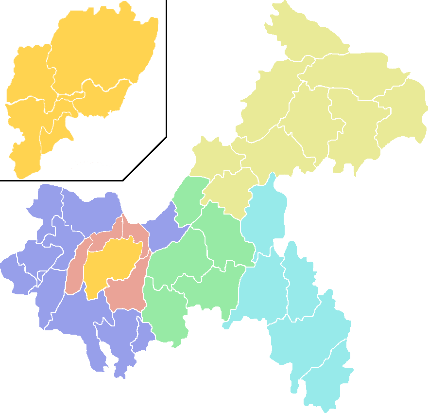
1. bishan
2. shuangqiao
3. Wansheng
Downtown
Yuzhong
Jiulongpo
Nan'an
Dadukou
Liangjiang
Shapingba
Banan
Yubei
By
1
Changshou
Hechuan
Jiangjin
2
3
Yongchuan
To do this
Qijiang
Rongchang
Tongliang
Tongnan
Fuling
Nanchuan
Dianjiang
Fengdu
Wulong
Qianjiang
Pengshui
Shizhu
Xiushan
Youyang
Wanzhou
Chengkou
Fengjie
Kaizhou
Liangping
Wushan
Wuxi
Yunyang
Zhong
Autonomous circles
The four Autonomous Counties are included in the rest of the structure, but are additionally listed here: Pengshui Autonomous County of the Miao and Tujia (彭水苗族土家族自治县, Péngshuǐ Miáozú Tǔjiāzú Zìzhìxiàn), Shizhu Autonomous County of the Tujia (石柱土家族自治县, Shízhù Tǔjiāzú Zìzhìxiàn), Xiushan Autonomous County of the Tujia and Miao (秀山土家族苗族自治县, Xiùshān Tǔjiāzú Miáozú Zìzhìxiàn), and Youyang Autonomous County of the Tujia and Miao (酉阳土家族苗族自治县, Yǒuyáng Tǔjiāzú Miáozú Zìzhìxiàn).
Author
AlegsaOnline.com Chongqing (municipality) — major city and municipality in southwestern China Leandro Alegsa
URL: https://en.alegsaonline.com/art/19963
Sources
- chinadigitaltimes.net : Zhang Dejiang Profile
- chinadaily.com.cn : Zhang Guoqing appointed as Chongqing acting mayor
- english.mofcom.gov.cn : "Doing Business in China - Survey"
- news.163.com : "重庆市2010年第六次全国人口普查主要数据公报"
- en.cq.gov.cn : City Flower
- wikidata.org : wikidata.org/wiki/Q11725
- catalogue.bnf.fr : cb150860406
- data.bnf.fr : (data)
- d-nb.info : 4315770-1
- id.loc.gov : n81082039
- musicbrainz.org : 440d7a96-021c-4e33-9894-42e4b03cbaf1
- catalog.archives.gov : 10046705
- id.ndl.go.jp : 00636793
- aleph.nkp.cz : xx0035565