
Topographic prominence
Topographic prominence measures how much a summit stands out from surrounding terrain: the height difference between the summit and the highest low point connecting it to any higher summit.
Overview
Topographic prominence, commonly shortened to prominence, quantifies a summit's independence by measuring how high it rises above the surrounding landscape. In plain terms, prominence is the vertical difference between a summit and the highest low point that must be crossed to reach any higher summit. This concept helps distinguish true mountains from subsidiary peaks and is widely used in mountaineering, cartography and geographic classification. For a simple reference to the summit concept see summit.
Image gallery
1 Image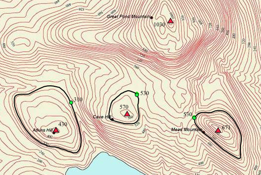
Calculation and key components
Calculating prominence involves two related elements: the low point between peaks (the col) and a chosen higher mountain (the parent peak). The specific col relevant to prominence is the highest such low point along the path that connects the summit to any higher summit — this is often called the key col. Prominence equals the summit elevation minus the elevation of the key col. In mapping terms, it can be read from isolines or computed from digital elevation models and contour data, sometimes using a contour line that encircles the summit and no higher terrain.
History and terminology
The idea of prominence emerged as climbers and mapmakers sought objective rules to list and compare peaks. Different regions and languages use varied names for the same concept: "autonomous height" or "relative height" are common English alternatives; in the United States it has been called "shoulder drop"; in parts of Europe it may be called "prime factor." Modern prominence tables and databases developed with improved surveying and digital elevation tools have standardized many procedures for computing values.
How to determine prominence (steps)
- Identify the summit and its elevation on a map or digital model.
- Find all possible routes to any higher summit and note the lowest points along those routes.
- Choose the highest of those low points — the key col.
- Subtract the key col elevation from the summit elevation: result = prominence.
Uses, examples and importance
Prominence is used to create objective mountain lists: for example, peaks with prominence above a set threshold are considered distinct mountains. A well-known category is the "ultra-prominent" peaks (often defined as those with prominence of at least 1,500 meters), which highlights mountains that dominate their regions. Some notable properties: the world’s highest mountain has a prominence equal to its elevation because there is no higher summit; similarly, the highest point on an island has prominence equal to its elevation above sea level because the sea forms the key col. Prominence complements other measures such as elevation and isolation to give a fuller picture of a peak's stature within the wider topography.
Distinctions and practical notes
Prominence differs from topographic isolation (distance to the nearest higher point) and from simple elevation. It can change slightly with improved mapping or revised sea-level data and occasionally depends on the rule used to select a parent peak. For mountaineers, prominence can indicate the significance of a climb; for geographers, it provides an objective metric to rank and compare summits worldwide. For further reading and data sources see: summit resources, regional mapping portals such as those for the United States and Europe, contour and elevation datasets contour line, and technical discussions of topography, cols and parent peaks.
Related articles
Author
AlegsaOnline.com Topographic prominence Leandro Alegsa
URL: https://en.alegsaonline.com/art/100655
Sources
- peaklist.org : "Orometry: Introduction to Prominence"
- peakbagger.com : "Glossary of Terms"