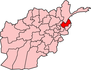
Parun — administrative center of Nuristan Province, Afghanistan
Parun is a small mountain town in eastern Afghanistan that serves as the administrative center of Nuristan Province; noted for remote terrain, Nuristani languages and traditional mountain life.
Parun is a small town in eastern Afghanistan that functions as the administrative center of Nuristan Province. It stands in a remote, mountainous area of the Hindu Kush range and is often described as a local hub for the surrounding valleys and villages. Parun's location in a rugged landscape shapes its climate, economy and transport links.
Geographically the town sits amid steep ridges and narrow river valleys. Coordinates commonly given for Parun are 35°25′N 70°55′E; these place it well inland from Afghanistan's major plains and nearer to the high country. The local climate tends toward cold winters and cool summers typical of high-altitude settlements.
Population in Parun is small compared with major Afghan cities; the wider district is sparsely settled. Residents include speakers of the regional Nuristani languages — an Indo-Iranian group distinct from Pashto and Dari — alongside other languages and dialects. Local customs and social life are closely tied to village networks, seasonal agriculture and pastoralism.
Historically, the wider Nuristan region had a distinctive cultural trajectory: it was only in the late 19th and early 20th centuries that the area became integrated into the modern Afghan state and experienced religious and administrative change. Parun's role as provincial capital developed as Nuristan was organized as a separate province; the town was chosen for its central position among local valleys.
Economically, Parun and its hinterland rely largely on subsistence farming, livestock herding, small-scale trade and local crafts. Road access is limited and often seasonal; travel to larger markets can be difficult, and the town serves as a local center for services, administration and education within a largely rural region.
Image gallery
2 Images
Notable facts
- Parun is the administrative capital of Nuristan Province (province details).
- It lies in eastern Afghanistan (country overview) in a remote mountain zone.
- Coordinates often cited for Parun are available via geolocation resources (map reference).
Related articles
Author
AlegsaOnline.com Parun — administrative center of Nuristan Province, Afghanistan Leandro Alegsa
URL: https://en.alegsaonline.com/art/74868