Democratic Republic of the Congo
Template:Infobox State/Maintenance/NAME-German
The Democratic Republic of the Congo (German [ˈkʰɔŋgo], French [kɔ̃ˈgo], abbreviated DR Congo), from 1971 to 1997 Zaire (French Zaïre), also known as Congo-Kinshasa or simply Congo, is a republic in Central Africa. It borders (clockwise from north) the Central African Republic, South Sudan, Uganda, Rwanda, Burundi, Tanzania, Zambia, Angola, the Atlantic Ocean, and the Republic of Congo. DR Congo is the second largest country in Africa by area (behind Algeria) and the fourth largest by population. The country is crossed by the equator; it has a tropical climate. Large parts of the national territory are covered by tropical rainforest.
The approximately 100 million inhabitants can be divided into more than 200 ethnic groups. There is a great diversity of languages, the lingua franca is French. About half of the inhabitants belong to the Catholic Church, the other half are Kimbanguists, other Christian churches, traditional religions and Islam. The capital, Kinshasa, is considered Africa's third largest city, with a population of over 13 million. Cities with over one million inhabitants are Lubumbashi, Mbuji-Mayi, Mbandaka, Kananga and Kisangani.
The territory of the present state came under Belgian colonial rule in 1885. The rule of the Belgian King Leopold II is considered one of the cruelest colonial regimes. After independence in 1960, the country was ruled dictatorially for 32 years by Mobutu Sese Seko after several years of internal political conflict. In 1997, Mobutu was overthrown by rebel leader Laurent-Désiré Kabila. The change of power was followed by another civil war, which became known as the African World War due to the involvement of numerous African countries. A peace agreement was signed in 2002. However, fighting continues to take place in the east of the country to this day. Free elections were held in 2006 for the first time since 1965.
Despite its wealth of raw materials, the state is now one of the poorest countries in the world, due to decades of exploitation, corruption, years of war and constant population growth.
Country names
The name of the Democratic Republic of Congo changed several times in the past. At times, the country used the same official name as the neighboring state of the Republic of Congo. The following table gives an overview of the historical designations:
| Historical naming of the territories of the Congo | ||
| former Belgian colony | former French colony(A) | former Portuguese protectorate |
| colonised from 1877 | 1880s colonized(G) | as of 1885 |
| from 1885 Congo Free State | from 1903 Middle Congo | |
| from 1908 Belgian Congo | 1910 French Congo | |
| as from 1958 Republic of the Congo | 1956 | |
| 30 June 1960 Independence | 15 August 1960Independence | |
| 1960 Republic of Congo (called Congo-Léopoldville) | 1960 Congolese Republic | |
| 1961 Federal Republic of Congo (called Congo-Léopoldville) | ||
| 1964 Democratic Republic of the Congo (called Congo-Léopoldville) | 1965 Republic of Congo | |
| 1966 Democratic Republic of the Congo (called Congo-Kinshasa) | ||
| 1971 Republic of Zaire | 1969 People's Republic of the Congo | 1974 |
| 1991/92 (Congo-Zaire) | ||
| since 1997 Congo Democratic Republic | since 1991 Congo Republic of | since 1975 Cabinda, |
| (A) as part of French Equatorial Africa (G) 1888-1910 also Gabon part of French Congo | ||
Natural Area
Geography
As the second largest state in Africa, the Democratic Republic of Congo covers an area of 2,344,885 km², making it 6.6 times the size of Germany and 76.4 times the size of the former colonial power Belgium.
It is located in central Africa on the equator. Because flora and fauna are very diverse, the country has a very high natural potential. Therefore, the opinion of many experts is that the Democratic Republic of the Congo would be one of the leading African states today, had there been no colonial exploitation and ethnic conflicts.
Around 60 percent of the country is covered by the Congo Basin with its tropical rainforests. It is bordered in all directions by mountain ranges with heights of 500 to 1000 metres. In the south, it is bordered by the Katanga Mountains (formerly known as the Shaba Mountains), which form part of the Lunda Sill. In the south and east of the country, the mountain ranges rise to high mountains such as the Mitumba Mountains and Kundelungu Mountains in the south and the Central African Threshold and Virunga Volcanoes in the east. They reach heights of up to 4500 metres and are rich in mineral resources such as copper and uranium. The highest elevation is Margherita Peak at 5109 metres in the Ruwenzori Mountains on the border with Uganda.
The largest and longest river flowing through the Democratic Republic of Congo is the Congo River, which is 4374 kilometers long. It is the second longest river on the African continent after the Nile. Measured by its water flow of 39,160 m³/s, it is the largest river in Africa and the second largest river in the world. The Congo rises in the south of the country in the Haut-Katanga province in the Mitumba Mountains and flows about 1000 kilometres to the north, from where it is diverted to the west-southwest. There is also an inland delta here. It then forms the border between the Democratic Republic of Congo and the Republic of Congo before finally flowing into the Atlantic Ocean. Numerous rivers flow into the Congo. By far the largest of these tributaries, with a flow of 9,873 m³/s, is the Kasai, which comes from Angola and also has several tributaries and rises in the mountains in the south. A left tributary of the Congo, the Lomami, which also rises in the south, has its headwaters in the Haut-Lomami province. The largest tributary of the Congo coming from the north is the Ubangi, which forms the border with the Central African Republic and the Republic of Congo for almost its entire length. The 40-kilometre-long coast north of the Congo's mouth into the ocean represents the only opening to the Atlantic Ocean. The two port cities of Muanda and Banana are located here; oil deposits are also found there. In the east of the country is the chain of lakes of the Great African Rift, which forms the eastern border. This includes (from north to south) Lake Albert, Lake Edward, Lake Kivu and Lake Tanganyika. It also holds significant mineral resources. Natural gas, for example, has been found here, as well as gold and tin in the east and northeast.
The Oxisol soils in the Congo Basin are often highly weathered and have low fertility, while the higher areas to the north and south are fertile and used for agriculture.
Climate
Due to its geographical location, the Democratic Republic of Congo has an equatorial climate. Most parts of the country therefore have a very warm, tropical humid climate with an average temperature of around 20 °C in the dry season and around 30 °C in the rainy season. The climate is relatively little influenced by seasons such as dry and rainy seasons. Nevertheless, there are regional disparities due to the very large area of the country.
The equator runs through the northern centre of the country, where the towns of Mbandaka and Kisangani are located. In this area, which is about 300 kilometres wide, there is heavy rainfall all year round, averaging around 1500-2000 mm, while the temperature remains constant at around 26 °C.
Kinshasa's climate is characterised by an average annual temperature of over 25 °C and an alternation between the dry seasons (four months in total) and the rainy seasons, which are at their most extreme in November and April. In the whole year, Kinshasa receives a total of about 1400 mm of rain.
In the north of the country, the large amount of forest, which is typical of the equatorial climate, leaves room for a tree savanna. There, in contrast to the south, the dry season usually begins two to three months before the turn of the year and ends around two to three months after the turn of the year. Therefore, about 90% of the annual precipitation falls here in the period between March and November.
A zone of tropical climate begins in the south, which has distinct seasons with a dry season (three to six months, mostly May to September) and a rainy season (six to nine months, mostly October to April). For example, Lubumbashi in Haut-Katanga province has as many as six months of relative dryness and very pronounced day-night temperature fluctuations.
The mountainous eastern part of the country is characterized by high altitude climate and is significantly cooler compared to the other areas. As the temperature there drops by an average of 1 °C per 80 metres of altitude, notable climatic and ecological differences can be seen in the rise of the mountains in the Virunga National Park and the slopes of the Ruwenzori Mountains. At the highest points of these areas, even snowfall is not uncommon. This is also where most of the country's rainfall occurs.
There is also a small zone of maritime climate. In the small coastal area in the far west, where the Congo River also flows in, the cold Benguela current significantly lowers the temperature and rainfall, so that in the town of Boma, for example, there is an average of less than 800 mm of precipitation per year.
flora and fauna
The Democratic Republic of Congo is home to the largest remaining rainforest areas in Africa. Since there are many endemic species, genera and families of plants and animals and diverse ecosystems in addition to a very large variety of species and biodiversity, the state is counted among the megadiversity countries of this earth. The Rwenzori Mountains are listed as a biodiversity hotspot due to the high level of endangerment.
About two-thirds of the country's surface is covered by tropical rainforest and high-altitude forest. At higher altitudes near the equator there is mainly mountain rainforest, cloud forest and cloud forest. Here one finds primarily trees and plants with long trunks, thin bark and firm leaves. Examples are the rubber tree and hardwood plants such as the teak tree and mahogany. There are also oil palms, strangler figs and perching plants such as orchids. North and south of the rainforest region are 200 and 500 kilometre wide strips of wet savannah. This distribution is due to precipitation and is based on the intra-tropical convergence zone (ITC). One plant genus found in the wet savanna area is spurge. The wet savannah eventually transitions into the dry savannah with miombo woodlands. The typical vegetation there consists mainly of acacias and succulents.
Although some mammals such as the lion, the leopard, the rhinoceros, the elephant, the zebra, the jackal, the hyena as well as a number of antelope species prefer to live in the savannah regions, there are a very large number of different mammal species in the country, mainly due to the high proportion of forest with a total of 415. In particular, five protected areas designated as UNESCO World Heritage Sites, the four national parks Garamba, Kahuzi-Biéga, Salonga and Virunga as well as the Okapi Wildlife Reserve, provide an important habitat for many mammals such as bonobos, eastern gorillas, okapis and African buffalo. The diversity of great apes is particularly remarkable: the Democratic Republic of Congo is the only country in the world that is home to three species of great apes: in addition to gorillas and bonobos, there are also chimpanzees. However, the latter are hardly to be found there and are acutely threatened with extinction. The situation of the bonobos is also threatening: the population of this species, which cannot be observed in the wild anywhere else in the world, is currently estimated at around 3000 animals in the country. Before the 1980s, this number was over 100,000. The main reason for the extinction of the apes are poachers who sell the bushmeat as a delicacy in the cities.
Other mammals also face the problem of species extinction. But unlike the delicacy of monkey meat, other endangered species are hunted mainly because of the immense protein needs of the rapidly growing population due to the very high fertility rate of women. Often the hunting of protected species is essential to the survival of country dwellers. But in this way, the populations of some wild animal species have dwindled to such an extent that, according to research forecasts, some species could be extinct in as little as 50 years.
The other classes of animals can also be found in large numbers. There are 268 different species of reptiles and over a thousand species of fish and birds each. The number of insect species is also very large. There are over 1300 different species of butterflies alone. In no other country in the world is this value greater.
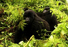
Mountain gorillas in Virunga National Park
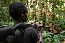
Congolese man with rifle hunting near Yangambi
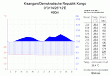
Climate diagram (Kisangani)
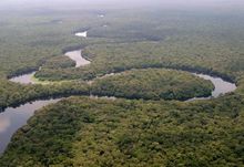
The Lulilaka River in Salonga National Park
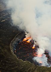
The constantly bubbling lava lake in the crater of Nyiragongo, one of the Virunga volcanoes, with a diameter of about 200 m the largest on earth. Its last eruption was in 2021.
-metrisch-deutsch.png)
Climate diagram (Kinshasa)
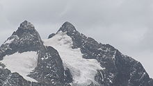
The glaciated Margherita peak of the Rwenzori massif, the highest mountain in both Congo and Uganda.
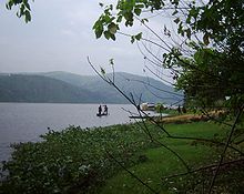
The Congo River
Questions and Answers
Q: What is the Democratic Republic of the Congo?
A: The Democratic Republic of the Congo is a country located in central Africa.
Q: What was the country known as from 1971 to 1997?
A: The country was known as Zaïre from 1971 to 1997.
Q: How does the country's population rank globally?
A: The Democratic Republic of the Congo is the nineteenth most populous nation in the world, with a population of over 71 million.
Q: What countries border the DRC to the north?
A: The DRC shares borders with the Central African Republic and South Sudan to the north.
Q: What is the DRC's access to the ocean?
A: The DRC has access to the Atlantic Ocean through a 40-kilometre (25 mi) stretch of coastline at Muanda and the Congo River's mouth, which is about 9 km wide and opens into the Gulf of Guinea.
Q: What is the DRC's rank for the total Christian population in Africa?
A: The DRC has the second-highest total Christian population in Africa.
Q: What countries border the DRC to the east?
A: The DRC shares borders with Uganda, Rwanda, and Burundi to the east.
Search within the encyclopedia