
Cape Race: Newfoundland headland, lighthouse, and maritime landmark
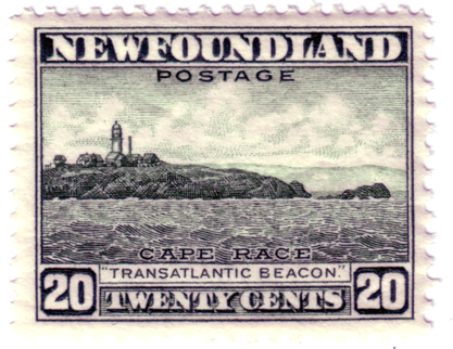
Cape Race, at the southeastern tip of Newfoundland's Avalon Peninsula, is a prominent headland known for its lighthouse, maritime radio history, hazardous fog banks and role in transatlantic navigation.
Cape Race is a rocky promontory at the southeastern extremity of the Avalon Peninsula on the island of Newfoundland. It projects into the North Atlantic and marks a notable point for vessels rounding the eastern approach to North America. The cape's position relative to offshore banks and prevailing currents has made it an important reference for mariners and weather observers. For regional context see Avalon Peninsula, Newfoundland and Canada.
Image gallery
3 Images

Geography and environment
The landscape at Cape Race is typically exposed and treeless, with windswept grasses and rocky shores. Cold Labrador Current waters meet warmer Gulf Stream influences farther south, producing frequent fogs and changing sea conditions in the vicinity. Those fogs, together with submerged shoals and the nearby fishing grounds known as the Grand Banks, have contributed historically to the area's navigational hazards.
Name and early cartography
The name "Cape Race" is believed to derive from an earlier Portuguese designation, "Raso," meaning "bare" or "flat." Early sixteenth‑century charts sometimes record the cape with that form, and the name may reflect a resemblance to a similarly named point near the Tagus estuary in Portugal. Over time the name evolved in English usage to the present form.
Maritime and communications history
Cape Race has long been a focal point in transatlantic shipping. In the later 19th and early 20th centuries, it hosted telegraph and wireless telegraphy stations that relayed messages between ships and shore. Operators at Cape Race were involved in several high‑profile rescues and communications events; most famously, the cape's wireless facilities received distress signals during the 1912 sinking of the RMS Titanic and participated in coordinating responses. The site thus occupies an important place in the history of maritime radio and safety at sea.
Lighthouse, weather reporting and modern role
A lighthouse and associated aids to navigation have been maintained at Cape Race to warn ships of nearby hazards and to assist coastal traffic. The location also serves meteorological monitoring functions: weather observations and fog reports produced there contribute to forecasts and warnings used by mariners and aviation services. As technology advanced, the cape's role shifted toward automated aids and integrated communications while preserving its status as a key geographic reference.
Notable facts and visitors
- Cape Race figures in cartographic histories because it appears on early European maps and charts.
- Its communications heritage links it to the broader story of wireless telegraphy and maritime safety.
- Visitors to the area often learn about shipwrecks, lighthouse operations and coastal ecology through interpretive displays and local information services.
For further reading on the cape's historical maps and name origin consult materials about Portuguese nautical nomenclature and early Atlantic navigation, or resources summarizing Newfoundland's coastal heritage. See also discussions on wireless telegraphy and transatlantic shipping that place Cape Race in a wider technical and social context; for a linguistic note on the name see Portuguese sources.
Related articles
Author
AlegsaOnline.com Cape Race: Newfoundland headland, lighthouse, and maritime landmark Leandro Alegsa
URL: https://en.alegsaonline.com/art/16722