
Cape Lookout (North Carolina)
A low, sandy headland on the southern tip of the Core Banks; part of Cape Lookout National Seashore, known for its lighthouse, barrier-island ecology, and recreational access from Beaufort.
Overview
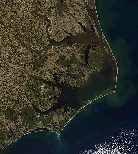
Cape Lookout is the southern point of the South Core Banks, a stretch of natural barrier islands off the central coast of North Carolina. The cape forms the dividing point between Onslow Bay to the west and Raleigh Bay to the east and is protected within the Cape Lookout National Seashore. The area is valued for its dynamic shoreline, maritime history, and relatively undeveloped beaches.
Image gallery
2 Images
Geography and natural features
The Cape occupies a shifting, low-lying spit of sand that responds to tides, currents and storms. Vegetation is typical of barrier-island environments: beach grasses, maritime shrubs and interdunal communities. These islands provide important habitat for shorebirds, sea turtles and other coastal species, and they act as a buffer that absorbs storm energy before it reaches the mainland.
History and navigation
Mariners have used Cape Lookout as a landmark for centuries. The most prominent human-made feature is the Cape Lookout Lighthouse, historically used to guide ships through the complex inlets and shoals of the North Carolina coast. The coastline here has been reshaped repeatedly by storms and longshore drift, which has influenced both navigation and settlement patterns.
Recreation and management
The cape and adjacent islands are popular for beachgoing, birding, fishing, boating and backcountry camping. Managed as part of a national seashore, the area is administered to balance visitor access with conservation. Facilities are limited to preserve natural conditions; visitors commonly reach the islands by private boat, ferry, or commercial water taxi from nearby harbors.
Access and location
Cape Lookout lies in Carteret County, roughly 11 miles southeast of the town of Beaufort, North Carolina. The cape's accepted coordinates are approximately 34°36′19″N, 76°32′10″W. For regional context and travel information consult local resources and park guides. For general reading on barrier islands see barrier island systems and for regional geography see North Carolina's Atlantic coast. The cape is part of the United States; federal and state rules apply to activities there (USA).
Practical notes and notable facts
- Administrative jurisdiction: Carteret County oversees mainland services nearest the cape.
- Nearest town with visitor services: Beaufort, NC.
- Commonly cited coordinates and mapping reference: 34°36′19″N 76°32′10″W.
Because conditions change rapidly on barrier islands, visitors should check weather, tides and park advisories before travel. The cape remains an example of an actively evolving coastal landscape with both ecological importance and cultural significance tied to maritime history.
Related articles
Author
AlegsaOnline.com Cape Lookout (North Carolina) Leandro Alegsa
URL: https://en.alegsaonline.com/art/16713