North Carolina: Geography, History, Economy and Culture
Comprehensive overview of North Carolina covering geography, history, economy, culture, government, and notable facts about its cities, landmarks and industries.
Overview
North Carolina is one of the 50 states in the United States. Its capital is Raleigh and its largest city is Charlotte. The state is divided into 100 counties and includes a mix of coastal plains, rolling Piedmont, and mountainous highlands. Today it is home to roughly ten million residents and a diverse economy that blends traditional agriculture and manufacturing with finance, technology, research, and film production.
Image gallery
10 Images


Geography and environment
North Carolina stretches from the Atlantic Ocean to the Appalachian Mountains, creating distinct regions. The Outer Banks and Atlantic coast feature barrier islands, estuaries and maritime forests. Inland, the Piedmont plateau hosts major cities and research centers. To the west rise the Blue Ridge and Great Smoky sections of the Appalachians; Mount Mitchell, in the state's western mountains, is the highest peak east of the Mississippi River. The state’s climate varies from humid subtropical along the coast to cooler mountain conditions at higher elevations.
History
Indigenous peoples, including the Cherokee and various Algonquian-speaking groups, lived in the region for thousands of years before European contact. In the late 16th century English colonists made early attempts at settlement on the coast, and the area later became one of the original Thirteen Colonies. North Carolina played roles in the American Revolution and the Civil War, and its economy shifted from plantation agriculture to tobacco, textiles and furniture manufacturing in the 19th and early 20th centuries. The mid-20th century onward saw growth in education, research and urban development.
Economy, education and innovation
The state’s economy is broad: finance and banking are centered in Charlotte, one of the nation’s major financial hubs; the Research Triangle area—anchored by Raleigh, Durham and Chapel Hill—combines major universities and technology and biotech firms; and ports on the coast support international trade. Agriculture remains important, with crops and livestock alongside forestry. North Carolina also developed a film and creative industry with production hubs on the coast and in the Piedmont.
- Major universities: public and private research institutions and large state universities.
- Key industries: finance, technology, biotechnology, higher education, agriculture and manufacturing.
- Notable sites: Research centers, ports, and historic flight site where early powered aviation took place.
Culture, attractions and notable facts
Cultural life in North Carolina draws on Appalachian music, coastal traditions and diverse urban arts. The state has distinct regional barbecue styles, vibrant craft and music scenes, and many museums and parks. Popular destinations include the beaches and lighthouses of the Outer Banks, mountain trails and state parks in the west, and museums, performing arts and sports venues in its cities. The Wright brothers’ first powered flight took place on the state’s coast, a commonly cited landmark in American aviation history.
Government and contemporary issues
North Carolina is governed under a state constitution with an elected governor and a bicameral legislature. Political debates often focus on economic development, education funding, coastal resilience to storms, and balancing urban growth with rural needs. In recent decades the state has frequently been highlighted in national surveys for its favorable business climate and has attracted companies and new residents for its universities, research facilities and urban job centers.
Geography
→ Main article: Geography of North Carolina
Location and extent
North Carolina is located on the southeast coast of the United States and borders the states of South Carolina and Georgia to the south, Tennessee to the west and Virginia to the north. The Atlantic Ocean lies to the east. The northern border of the state runs along the latitude from 36°35′10″ on the west to 36°32′27″ on the east. The western border runs along the crest of the Appalachian Mountains. The southernmost point of the state is at 33°50′57″ north latitude; its north-south extent measures 300.3 kilometers, and its west-east extent between 75°27′15″ and 84°19′01″ west longitude is 807.4 kilometers. The state covers an area of 139,389 square kilometres, of which 125,919 square kilometres is land area, making it slightly larger than Greece.
Regions
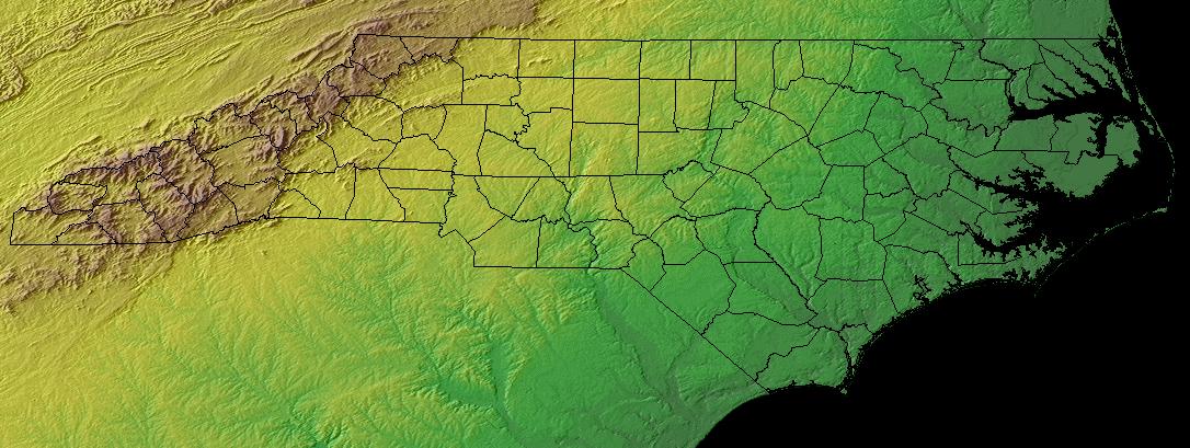
Geographically and geologically, North Carolina can be divided from east to west into three major parts: the coastal plain on the Atlantic Ocean, the Piedmont Plateau in the hinterland, and the Appalachian mountain region.
About two-thirds of the state is occupied by the Atlantic coastal plain. The soils of the very flat plain are sandy and are covered with dense forests consisting mainly of pines and other evergreen trees. The soils are particularly suitable for the cultivation of tobacco, soya, melons and cotton. This region, which includes the Inner Banks, is the most rural of North Carolina, with only a few major cities and towns. Offshore from the land are the Outer Banks, a chain of narrow and variable dune islands that form a barrier between the Atlantic Ocean and inland waterways. The Outer Banks enclose the two largest lagoons in the United States, Albemarle Sound to the north and Pamlico Sound to the south, whose area exceeds that of the state of Connecticut. North Carolina's coast lacks a suitable natural harbor, so it never developed a major seaport such as Charleston in South Carolina or Savannah in Georgia. The state's only major port, Wilmington, is located about 25 kilometers inland on the Cape Fear River. The Coastal Plain is the largest and also the youngest geological section of the state. It consists mainly of sedimentary rocks, mostly sand and clay, with limestone also found in the southern part of the coastal plain. The state's most economically important mineral, phosphate usable for fertilizer, is mined in this region. The Coastal Plain is bounded by the three-million-year-old coastline 90 meters above present-day sea level, also known as the fall zone, where the Piedmont Plateau drops relatively steeply to the coastal region, and where the state's Appalachian rivers have rapids and waterfalls.
The Piedmont region in the center of the state is the most urbanized and densely populated region of North Carolina. The Piedmont is a rolling landscape, frequently interrupted by smaller foothills and river-carved valleys, formed from almost completely eroded remnants of higher mountains. The geologic structures are dominated by the Inner Piedmont Belt with ages ranging from 750 to 500 million years of the Kings Mountain Belt, Milton Belt, Charlotte Belt, Carolina Slate Belt, Raleigh Belt, and the Eastern Slate Belt, all of which range in age from 650 to 300 million years. Also part of the Piedmont are the much younger Triassic Basins, 200 to 190 million years old, former subsidence trenches that were filled by mud and scoured sediments from adjacent higher elevations. In the Carolina Slate Belt, the first gold discovery in the United States was documented in 1799, and mines were operated to extract gold in the early 19th century; today, in addition to lithium and clay, granite, gneiss, and other materials for construction are primarily mined in this region. The elevation of the Piedmont ranges from about 90 meters in the east to 300 meters above sea level in the west. The soils consist mainly of thin stony layers on a clay base; only on the eastern edge of the plateau are sandy hills marking a former coastline with its dunes and beaches. Peaches and melons, for which the region is known, are the main crops grown on the well-moistened soils. Due to the rapid urbanization of the landscape since the 1970s, agriculture has been and continues to be largely displaced, giving way to a suburban structure.
The Appalachian mountain range forms the western border of the state. The mountains in North Carolina's territory can be divided into four ranges. The Blue Ridge Mountains are the largest range and run in a winding line through the western part of the state with occasional high spurs over the surrounding terrain; Mount Mitchell, at 2037 m, is the highest elevation in the state and also the highest point in the United States east of the Rocky Mountains. The Great Smoky Mountains, also known as the Smokies, form the western border of the state and are the second highest mountain range in North Carolina. The oldest rock, at about one and a half billion years old, is found in the western part of the state. The belt known as the Blue Ridge Belt, which also includes the smaller Murphy Belt and Grandfather Mountain Window sections, consists of igneous, sedimentary, and metamorphic rocks containing feldspar, mica, and quartz. The Brushy Mountains are much smaller and lower, their highest peak being Pores Knob. It is 817 metres above sea level. The Uwharrie Mountains are the easternmost and oldest and lowest mountain range in North Carolina. The highest elevation of this range is High Rock Mountain at less than 350 meters above sea level. Between the mountains are fertile valleys interspersed with numerous rivers and streams. The mountains themselves are covered with lush forests, with only a few peaks bare with prairie-like vegetation. Although agriculture still plays an important role in this region, the importance of tourism is steadily increasing and has become the most important economic sector of the mountain region.
Waters
North Carolina's river systems can be divided into two main groups. The main eastern watershed of North America runs along the crest of the Appalachian Mountains. Only the rivers in the extreme west of the state drain to the Gulf of Mexico by way of the Mississippi; the rivers which rise on the eastern flank of the mountains empty into the Atlantic. The latter are further subdivided as to their mouths, which are either in the territory of North or South Carolina. The division between the river systems that flow into the Atlantic is caused by an elevation that runs southeast from the foothills of the Blue Ridge Mountains almost to the port city of Wilmington along the Virginia border.
The Catawba River and the Yadkin River, with their tributaries, flow through about 30 counties in the state. They fan out across the country, draining much of the Piedmont before flowing across the border into South Carolina and reaching the coast. Chowan, Roanoke, Tar, Neuse, and Cape Fear Rivers empty into North Carolina and were important trade routes before railroad routes were built. Only one of the rivers flows directly into the sea; the others fan out farther and farther in the coastal plain and empty into the sounds. These lagoons and the rivers that flow into them create a network of waterways some 1800 kilometres long, suitable for steam and sail navigation.
The banks of the rivers are lined with riparian forests of poplars, willows and alders in the upper reaches, and with forests of bald cypress in the shallow lower reaches. In their course from the high plateaus to the lowlands, they overcome differences in altitude of several hundred metres through rapids and waterfalls. In the colonial past, cotton mills and other businesses such as sawmills often took advantage of this gradient, encouraging the rise of many cities and towns. The sounds and shallower rivers of the low-lying coastal plain provide rich fish stocks and colonies of waterfowl.
Smaller natural lakes are found throughout North Carolina; however, damming of rivers by power companies has also created larger reservoirs and dams that serve as tourist destinations, recreational areas, and hunting and fishing regions in addition to flood control and power generation. One major lake area, for example, was created by the backwater of the Yadkin River at the foothills of the Uwharrie Mountains: the Uwharrie Lakes. The largest of these lakes is High Rock Lake. The largest man-made lake in North Carolina, covering 129 square miles, is Lake Norman, a reservoir on the Catawba River, on whose shores Lake Norman State Park was created.
Climate
Warm temperate rainy climates prevail throughout most of the state, with the exception of the higher elevations in the Appalachian Mountains, which are considered part of the fully humid boreal climate zone. The mountains often serve as a "shield" for the Piedmont region, keeping out low temperatures and storms from the Midwest. The average daytime temperature in most areas of the state is around 32 °C in July. In January, temperatures average around 10 °C.
The coastal plain is climatically influenced by the Atlantic Ocean, which provides mild weather in winter and moderately warm weather in summer. The daily maximum temperature on the coast is 31 °C in summer, while temperatures rarely fall below 4 °C in winter. The average daily maximum temperature in the winter months is around 15 °C in the coastal plain, and temperatures below freezing are extremely rare. The Coastal Plain receives about two inches of snow annually, and many winters are completely free of snow and ice. In the Piedmont, however, summers are warmer and winters are colder than in the Coastal Plain. Daytime high temperatures average over 32 °C in summer, but rarely rise above 37 °C. In winter, daytime temperatures average around 10 °C and often drop below freezing at night. Annual snowfall ranges from 7 to 20 centimeters. Winter weather in the Piedmont is known for sleet showers and freezing rain, which in some storms can be so heavy that trees and power lines collapse under the load. Annual rainfall and humidity in the Piedmont are lower than on the coast or in the mountains, with about 1000 liters per square meter of precipitation recorded annually. The coolest area of North Carolina is the Appalachian Mountains; there the temperature rarely rises above 26 °C in summer. Average daily temperatures in winter range from -1 °C to 5 °C, often dropping below -9 °C. Snowfall ranges from 36 to 51 centimeters per year, usually more in the higher elevations.
Because of its exposed location on the Atlantic coast in the far southeast, North Carolina is hit with great force by a hurricane on average once every decade, with additional tropical storms hitting the state about every three to four years. In some years, North Carolina may be hit several times by a hurricane and additional tropical storms, or feel the effects of the foothills of these storms in the coastal plain. Only the states of Florida, Texas, and Louisiana are hit by hurricanes more frequently than North Carolina. On average, thunderstorms are recorded 50 days per year, some severe enough to produce hail and hurricane-force wind gusts. Although most hurricanes cause damage in the coastal regions of the state, they can certainly reach inland and cause major destruction. On an annual average, North Carolina experiences fewer than 20 tornadoes, most of which are caused by hurricanes or tropical storms in the coastal plain. Tornadoes resulting from thunderstorms occur in the eastern parts of the state, while the western Piedmont is often protected from such storms by the mountains. Another weather phenomenon called cold air damming, the buildup of cold air masses, occasionally occurs in the western part of the state. This can weaken storms, but also leads to heavy freezing rain in the winter.
fauna and flora
The fauna and flora of the state present a very varied picture, ranging from the sparse and shallow-rooted growth of the coastal region and the American alligators that inhabit it, to the coniferous forests in the Appalachians inhabited by bears and white-tailed deer. The typical plants and animals of the Southeast are represented in the lowlands, while the higher elevations are home to more northern-distributed species. A total of about 300 tree species and subspecies, and about 3000 different flowering plants have been counted. Several of the plants and animal species found in North Carolina are considered endangered, partly referring to the occurrence in the state, but also nationally endangered species have their habitat in North Carolina, for example various whale species and the Blue Ridge goldenrod.
In the coastal region, the salt marshes and marshlands are colonized mainly by the mudgrass Spartina patens and the grass Distichlis spicata, and on coastal dunes grows the tall grass Uniola paniculata (sea oats). The main tree species are Virginian cedars and pines, but the region's blackwater swamps also provide good growing conditions for bald cypresses, swamp magnolias and tupelo trees. Worldwide exclusive to the Pocosin marshes around Wilmington, the Venus flytrap is common. In addition to various saltwater and freshwater fish, oysters, sea turtles, and the protected American alligators live in the state's rivers, lakes, and coastline. A unique feature of the Outer Banks are the bank ponies that live semi-feral on the island chain.
In the Piedmont, the trees can root deeper, and the forests are dominated by various species of oak and hickory, and formerly also by American chestnut. Various species of poplar, birch, linden, horse chestnut, and maple grow there, along with, for example, Carolina hemlock and several species of orchids. Common animal species include raccoons, squirrels, opossums, some endangered bat species, and beavers. The rivers and lakes are inhabited by bass, catfish, and other fish, and there are also a variety of different waterfowl, especially species of ducks and geese.
Towards the mountains the vegetation changes into coniferous forests, partly the habitats of the animals overlap with the Piedmont. Gray wolves and mountain lions are already extinct, but bobcats can be found in the forests of North Carolina. The Great Smoky Mountains area is also home to black bears, which are now a tourist attraction. Wild hogs, introduced as recently as the 19th century, are common, as are white-tailed deer. Trout and bass live in the clear rivers of the mountains.


Population
Population density
The state's population density is 63.8 residents per square mile. North Carolina's major cities are almost exclusively located in three metropolitan areas, which are home to more than half of the state's total population:
- The cross-border agglomeration "Metrolina" in the area of the cities of Charlotte, Gastonia and Salisbury (North Carolina) on the territory of North and South Carolina with about 2.2 million inhabitants.
- The "Triangle", a triangle between the cities of Raleigh, Durham and Cary with a population of over one and a half million.
- The "Piedmont Triad" between Greensboro, Winston and Salem-High Point with a population of approximately 1.5 million.
The three largest cities are Charlotte with a population of 842,051, Raleigh with 375,806, and Greensboro with 247,183. For more cities and towns, see the list of cities in North Carolina.
Population development
| Population development | |||
| Census | Inhabitants | ± in % | |
| 1790 | 393.751 | - — | |
| 1810 | 753.419 | - — | |
| 1850 | 869.039 | - — | |
| 1860 | 992.622 | 14,2 % | |
| 1870 | 1.071.361 | 7,9 % | |
| 1880 | 1.399.750 | 30,7 % | |
| 1890 | 1.617.949 | 15,6 % | |
| 1900 | 1.893.810 | 17,1 % | |
| 1910 | 2.206.287 | 16,5 % | |
| 1920 | 2.559.123 | 16 % | |
| 1930 | 3.170.276 | 23,9 % | |
| 1940 | 3.571.623 | 12,7 % | |
| 1950 | 4.061.929 | 13,7 % | |
| 1960 | 4.556.155 | 12,2 % | |
| 1970 | 5.082.059 | 11,5 % | |
| 1980 | 5.881.766 | 15,7 % | |
| 1990 | 6.628.637 | 12,7 % | |
| 2000 | 8.040.550 | 21,3 % | |
| 2010 | 9.535.483 | 18,6 % | |
| Before 1900 1900–1990 2000 | |||
North Carolina's population has been growing steadily for decades, increasing from 6.6 million to 8 million residents between 1990 and 2000. According to the U.S. Census Bureau, there were 9,380,884 residents living in the state as of July 1, 2009, an increase of 16.7% or 1,340,334 residents since 2000. This figure significantly exceeds the average U.S. growth rate, which is about 8%. The growth includes a natural population increase of 412,906 people, 1,015,065 children were born, and 602,159 people died. During the same period, 591,283 people migrated to North Carolina from other states, and 192,099 immigrants came from abroad. Between 2005 and 2006, North Carolina overtook the state of New Jersey to rank as the 10th most populous state.
North Carolina residents classify themselves as belonging to the following population groups: 74% White, 21.7% African-American, 7.0% Central or Latino, 1.9% Asian, 1.2% Native American. 6.7% of the population is under 5 years of age, 24.4% is under 18, and 12% is 65 years of age or older. Women are estimated to make up 51.1% of the population.
Populations
African American
Just over one-fifth of the state's population is of African American descent; since the 1970s, their share of the middle class has been increasing due to improved access to education. The African American population lives primarily in the coastal plain to the east and in parts of the Piedmont Plateau, historically a region where blacks have worked and where most jobs are still created today. African American communities exist by the hundreds in rural counties in the south central and northwestern parts of the state; neighborhoods with predominantly black populations exist in the cities of Charlotte, Raleigh, Durham, Greensboro, Fayetteville, Wilmington, and Winston-Salem.
The family histories of those recorded as "other free persons" in the state census between 1790 and 1810 show that they were 80% descended from migrant free blacks from colonial Virginia. Most were descended from free African American families from unions between free white women or indentured servants and free African men bound in labor contracts or enslaved. Indians who adopted English customs became part of African American communities and married into those families. Some lighter-skinned descendants formed their own communities separate from the others and often referred to themselves as "Indians" or "Portuguese" to escape the negative consequences of black ancestry. Few African Americans live in the mountainous regions and the rural Piedmont; in some Appalachian counties, black residents historically never numbered more than a few dozen citizens.
Asian American
The earliest evidence of Asian immigration dates back to the recruitment of agricultural laborers from China in the mid-1800s. The famous Chinese-Malay Siamese twins Chang and Eng Bunker settled in Wilkesboro in 1839. Japanese, Filipino, and Korean Americans settled in North Carolina beginning in the early 20th century. The state is home to one of the fastest growing Asian American populations in the country, this is composed primarily of Indian Americans (Desi) and Vietnamese Americans. Their populations nearly quadrupled in the years between 1990 and 2002. The numbers of people of Hmong descent in North Carolina have increased to 12,000 since the 1980s.
European Americans
The coastal region, which was settled first, attracted mostly English immigrants, including many indentured servants transported to the colonies and descendants of Virginia immigrants. In addition, Protestant immigrants from continental Europe, especially Huguenots and German Swiss, settled in New Bern. Welsh immigrants settled east of present-day Fayetteville in the 18th century, along with other groups from the British Isles.
Americans of Scotch-Irish and English descent live throughout North Carolina, while historically the Piedmont and upstate were settled by the Scotch-Irish and Northern English immigrants. They were the last and most numerous group of English immigrants to arrive in North Carolina before the War of Independence. They settled the southern part of the mountain region where they were able to lead their time-honored independent way of life, mostly as self-sufficient farmers.
In the Winston-Salem region, a significant portion of the population is descended from German-speaking immigrants from Bohemia. These immigrated to North Carolina as part of a wave of immigration by the Protestant Herrnhuter Brüdergemeinde in the mid-18th century. During the early 20th century, a group of Orthodox immigrants from Ukraine settled in Pender County.
Hispanics and Latinos
Since 1990, the number of Hispanics and Latinos in North Carolina has been rising rapidly. Originally migrant workers, they mostly work as unskilled laborers. Access to this field has been made easier and, as a result, more and more Hispanics are settling in the state. They are mostly from Mexico, Central America and the Dominican Republic. Hispanic neighborhoods now exist in many cities, and there are larger numbers of Cuban Americans and Puerto Ricans. The Pew Hispanic Center estimated in 2005, based on U.S. Census Bureau figures, that about 65% of Latinos in North Carolina, or 300,000 people, entered the country as illegal immigrants. The Hispanic population has thus grown from 77,726 people in 1990 to 517,617, an increase of 13.5% per year.
North American Indigenous Peoples
Only five other states, namely California, Arizona, Oklahoma, New Mexico and Texas, have more American Indians than North Carolina. In total, there are 2,824,751 persons of American Indian or Alaska Native origin in the United States, or 0.95% of the total population. North Carolina was home to an estimated 111,853 American Indians in 2007. The state recognizes eight tribes within its borders, although only one is federally recognized as a federally recognized tribe.
federally recognized Indian tribe
- the Eastern Band of Cherokee Indians was recognized by the United States in 1868 and by North Carolina in 1889. With about 13,400 enrolled tribal members, they live mostly in the eastern portion of Swain, Graham, and Jackson counties. Most live on the Qualla Boundary reservation, which covers an area of 230 sq. km. The capital and administrative headquarters of the Eastern Band of Cherokee is Cherokee.
state recognized Indian tribes
- the Haliwa-Saponi Indian Tribe received state recognition in 1965 and comprises slightly more than 3,800 enrolled members, are descendants of the Sioux-speaking Saponi, Occaneechee, Tutelo, Keyauwee, Enoke (Eno), Shakori, the Stuckanox, and the Algonkin-speaking Nansemond and Iroquoian-speaking Tuscarora, administrative headquarters is Hollister, now live in northeast Halifax and Warren counties.
- the approximately 2000 tribal members of the Waccamaw Siouan Tribe live in Bladen and Columbus counties on the Atlantic coast. They were recognized by North Carolina in 1971. They are not to be confused with the Waccamaw Indian People (of Conway) (also Chicora Waccamaw) in South Carolina, who are also state recognized.
- the Coharie Indian Tribe, represented by the Coharie Intra-tribal Council, administrative seat is Clinton, own land in the area of Sampson and Harnett Counties, are descendants of the Neusiok, were already recognized by the USA in 1911, but this recognition was initially not accepted by North Carolina. Another recognition process in 1971 was successful.
- the Sappony Tribe was recognized as a tribe by North Carolina in 1911, includes about 850 enrolled members, administrative headquarters is located in High Plains Indian Settlement, was formerly known as Indians of Person County, North Carolina, changed name to Sappony Tribe in 2003 to refer to their origin and culture.
- the Occaneechee Band of the Saponi Nation (called the Eno-Occaneechi Indian Association until 1995), descendants of the Occaneechee, Enoke (Eno), and Saponi, living with 800 members in Orange and Alamance counties, became the eighth tribe of North Carolina to be recognized by the state on February 4, 2002.
- the Meherrin Indian Tribe, related to the once neighbouring Iroquoian-speaking Tuscarora and the northern Iroquois, lives predominantly in the rural areas of Hertford, Bertie and Gates counties in northeastern North Carolina near the river of the same name at the border to Virginia, was recognized as a tribe by North Carolina in 1986 and comprises about 900 members, administrative seat is in the village of Winton, today the smallest tribe in North Carolina.
- of the Lumbee Tribe of North Carolina live mostly in Robeson, Hoke, Cumberland and Scotland counties in the southeastern part of the state, the cultural and administrative center being the town of Pembroke. They represent a special case. The U.S., with the so-called Lumbee Act of 1956, recognized them as a tribe on the federal level, but denied them all the rights and supports officially recognized tribes are entitled to by the federal government. Recognized as an Indian people by the state of North Carolina under the name Croatan Indians as early as 1885, the government changed the tribal name to Indians of Robeson County in 1911 and Cherokee Indians of Robeson County in 1913. In 1953, the name was changed to Lumbee Tribe of North Carolina, descendants of mostly Cheraw and related Sioux-speaking tribes as well as African-Americans (mostly runaway slaves) and whites, they are therefore now counted by researchers as tri-racial isolates, that is, as an isolated population descended from three ethnic groups (Indians, African-Americans, and whites). With about 55,000 members, the Lumbee are the eighth largest Indian tribe in the USA, the largest east of the Mississippi and North Carolina.
Religions
North Carolina is part of the Bible Belt, where the population has traditionally been overwhelmingly Protestant, with Southern Baptists dominating in the late 19th century. With the influx of citizens from northern states and immigrants from Latin America, the proportion of Catholics and Jews is steadily increasing; in 2007, Catholics accounted for 7% of the population, and Jews 1%. The change is most visible in the urban areas of the state, where most of the immigrants have settled and the population comes from a wide variety of cultural backgrounds. In rural areas, the Baptist Church remains the predominant Christian denomination at 38%, followed by the second largest Protestant church, the Methodists at 9%. These are strongly represented in the northern Piedmont, especially in Guilford County. There and in the northeastern part of the state there is also a considerable proportion of Quakers. The members of the Presbyterian Church, originally of Scotch and Irish descent, constitute 3% of the faithful. They are particularly strong in Charlotte and in Scotland County. Other denominations in the state include Lutherans, Congregationalists, Mormons, and the Church of God. The percentage of non-religious residents of the state, or atheists and agnostics, is 10%.
Major religious denominations in 2010: 1,513,059 Southern Baptist Convention, 659,064 United Methodist Church, 565,051 Protestantism without denominational, 428,860 Catholic Church (Diocese of Charlotte/Bishopric of Raleigh), over 300,000 Pentecostal, 185,669 Presbyterian Church (U.S.A.). There are many other denominations, primarily Protestant.


Questions and answers
Q: What is the capital of North Carolina?
A: The capital of North Carolina is Raleigh.
Q: What is the largest city in North Carolina?
A: The largest city in North Carolina is Charlotte.
Q: How many counties are there in North Carolina?
A: There are 100 counties in North Carolina.
Q: When was the first English colony established in America?
A: The first English colony was established in America in what would become North Carolina.
Q: How many people were living in North Carolina as of July 1, 2014?
A: As of July 1, 2014, there were about 10,146,788 people living in the state.
Q: In which year did Forbes rank North Carolina number one on its Best States for Business ranking for a second year running?
A: In 2018, Forbes ranked North Carolina number one on its Best States for Business ranking for a second year running.
Related articles
Author
AlegsaOnline.com North Carolina: Geography, History, Economy and Culture Leandro Alegsa
URL: https://en.alegsaonline.com/art/70841
Sources
- commons.wikimedia.org : North Carolina
- kff.org : "Median Annual Household Income"
- mla.org : "North Carolina"
- nc-climate.ncsu.edu : "Overview"
- reason.org : "16th Annual Report on the Performance of State Highway Systems"