Vale of White Horse
Rural district and historic lowland in Oxfordshire, England, named for the Uffington White Horse; includes Abingdon, Wantage and Faringdon and encompasses many villages and heritage sites.
Overview
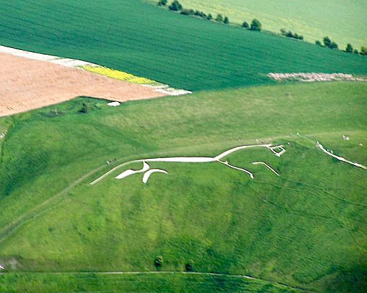
The Vale of White Horse is a predominantly rural local government district and recognised historic landscape in the county of Oxfordshire, in England. Its identity takes its name from the prehistoric hill figure, the Uffington White Horse, and from the broad lowland that lies between the chalk scarp of the Berkshire Downs and the floodplain of the River Thames. The district combines agricultural land, market towns and dispersed villages across largely gently undulating terrain.
Image gallery
7 Images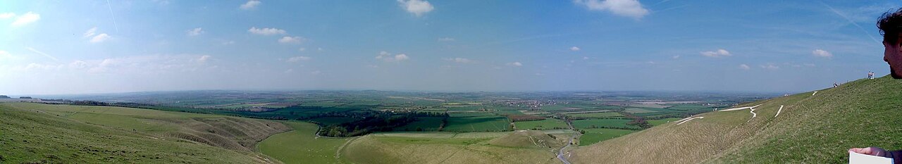


Geography and landscape
The vale occupies a ribbon of countryside defined by geology and river corridors. The chalk downland to the south gives way to clay-with-flints and alluvial soils that support mixed arable farming, hedgerows and small woodlands. The Uffington White Horse, its surrounding prehistoric remains and local hillforts create a distinctive skyline; the area is valued for long views, biodiversity and a strong sense of historic continuity.
Towns and communities
Principal towns in the district include Abingdon, historically important and a local service centre; Wantage, a market town with long-standing regional links; and Faringdon, known for its hilltop position near the downs. The district contains many smaller villages and, in administrative terms, numerous civil parishes such as those grouped under the generic term parishes. Local communities often centre on village churches, markets and voluntary organisations.
History and administration
The modern administrative district was created on 1 April 1974 under the reorganisation set out in the Local Government Act 1972. While boundaries and governance were adjusted in that period, the vale's cultural history is much older, with archaeological evidence ranging from Bronze Age earthworks to medieval settlement patterns. Governance today combines district-level services with parish councils and county responsibilities.
Economy, heritage and conservation
Agriculture remains an important part of the local economy, complemented by small manufacturing, tourism and local services. Heritage assets such as the Uffington White Horse, ancient trackways and traditional buildings attract visitors and underpin conservation efforts. Local and national bodies work with communities to manage landscape-scale conservation, protect archaeological sites and sustain rural livelihoods.
Recreation and access
The vale offers recreational opportunities including walking on public footpaths and rights of way, visiting heritage sites, and exploring market towns. Public access routes often link downs, villages and river corridors, providing scenic routes for visitors and residents. Information about local amenities and visitor guidance is typically available through district and community outlets.
Further information
For administrative details, community services and local planning, consult the district council and parish contacts. Historical and archaeological summaries are available from regional heritage organisations and research outlets. Readers seeking official information or visitor advice should refer to local authority and conservation resources for up-to-date guidance.
Questions and answers
Q: What is the Vale of White Horse?
A: The Vale of White Horse is a local government district of Oxfordshire in England.
Q: What is the main town in the Vale of White Horse?
A: The main town in the Vale of White Horse is Abingdon.
Q: What other places are located in the Vale of White Horse?
A: Other places located in the Vale of White Horse include Faringdon and Wantage.
Q: How many parishes are within the Vale of White Horse district?
A: There are 68 parishes within the Vale of White Horse district.
Q: What is the geography of the Vale of White Horse?
A: The Vale of White Horse is a region between the Berkshire Downs and the River Thames.
Q: How did the Vale of White Horse get its name?
A: The Vale of White Horse was named after the prehistoric Uffington White Horse.
Q: When was the Vale of White Horse district formed?
A: The Vale of White Horse district was formed on 1 April 1974, under the Local Government Act 1972.
Related articles
Author
AlegsaOnline.com Vale of White Horse Leandro Alegsa
URL: https://en.alegsaonline.com/art/103953