Lagos: Nigeria's largest city and West African economic hub
Lagos is Nigeria's largest city and one of Africa's major urban centres. A coastal megacity of islands, lagoons and dense neighbourhoods, it is the country's commercial heart and a regional gateway.
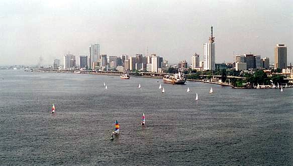
Lagos is Nigeria's largest city and one of the continent's most populous urban areas. It occupies a coastal position on the Gulf of Guinea and the Lagos Lagoon, combining densely built mainland districts with a collection of islands and peninsulas. Population estimates for the metropolitan area vary widely depending on boundaries and methods, with commonly cited figures ranging from about 12.5 million to over 18 million inhabitants. This rapid growth has made Lagos a dynamic economic, cultural and transport hub in West Africa.
Image gallery
10 Images


Geography and urban structure
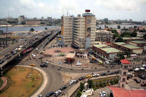
The city's footprint extends across mainland neighbourhoods and a series of islands and waterways. Prominent island districts include Victoria Island and Banana Island, while other notable landforms and communities include Ikoyi, Snake Island and waterfront settlements. The metropolis is organized administratively into multiple local government areas and districts — examples include Surulere, Agege, Somolu and Oshodi — each with local services such as hospitals, courts and police stations.
Economy and role
Lagos functions as Nigeria's principal commercial centre. Its port facilities, financial institutions, wholesale markets and growing technology and creative sectors sustain a large share of the country's trade and employment. The city is also a center for Nigeria's film and music industries, contributing to a regional cultural influence. Because of this concentration of activity, Lagos serves as a gateway for businesses and visitors entering West Africa and is frequently described as the country's commercial capital.
History and political status
Lagos has a long history as a coastal trading settlement that expanded dramatically under colonial rule and after independence. It served as the national capital for several decades before the federal government officially moved the capital to a purpose-built inland city in the early 1990s. Despite the relocation of political institutions, Lagos remains the most important economic and population center in the country. The state capital within the metropolis is Ikeja, which hosts major administrative functions and the city's principal international airport.
Transport, development and challenges
The city's transport network mixes major roads, bridges, rail initiatives and a busy port. Iconic links such as multiple causeways and newer bridges connect islands to the mainland, and authorities have invested in light rail and bus systems to reduce congestion. Rapid urbanization has created persistent challenges: traffic congestion, housing shortages, environmental stress on lagoon and coastal systems, and the need for infrastructure and public services to keep pace with growth.
Local government areas and notable districts
- Examples of local government areas include Somolu, Koshofe, Ifelodun and Surulere; each provides public services at a local level.
- Mainland and suburban wards such as Agege, Ikeja and Ikorodu form significant residential and commercial zones—see Ikorodu as an example of a major suburban area.
- Island districts like Victoria Island and Banana Island are prominent for business, finance and upscale housing.
Further context and resources
For comparative context about its size and status among African cities consult materials on population ranking and regional urbanization trends in West Africa. Background on Nigeria and federal institutions can be found through general overviews of Nigeria and the country's capital relocation to Abuja. For maritime and coastal geography, see resources about the Atlantic Ocean and Gulf of Guinea. Detailed economic and commercial profiles are available via publications addressing Lagos as a commercial capital.
Lagos remains a city of contrasts: immense entrepreneurial energy, cultural production and economic opportunity sit alongside infrastructure pressures and environmental vulnerability. Its continued growth and transformation will shape not only Nigeria's future but also broader urban trends across West Africa.
Related articles
Author
AlegsaOnline.com Lagos: Nigeria's largest city and West African economic hub Leandro Alegsa
URL: https://en.alegsaonline.com/art/55395
Sources
- premiumtimesng.com : "18th National Sports Festival: Lagos unveils Logo, mascot and website"
- thisdaylive.com : "Eko 2012: Building Branding through Sports, Articles"
- citypopulation.de : "Metro Lagos (Nigeria): Local Government Areas"
- ng.boell.org : "Lagos and Its Potentials for Economic Growth"
- demographia.com : Demographia World Urban Areas
- lagosstate.gov.ng : "Population-Lagos State" · web.archive.org
- books.google.com : Bradt Travel Guides