
Gooding County, Idaho
Gooding County, located in southern Idaho, is a small agricultural county with the city of Gooding as its seat. Named for Frank R. Gooding, it includes sites such as Hagerman Fossil Beds and had 15,464 residents in 2010.
Gooding County is a rural county in the western United States, situated in the southern part of Idaho. It is part of a landscape shaped by the Snake River and irrigation systems that support grain, potato and dairy agriculture. The county seat is the city of Gooding, which serves as the administrative and cultural center for the area.
Image gallery
1 Image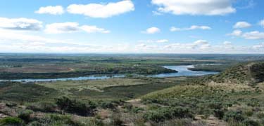
Characteristics and economy
The county's economy is dominated by agriculture and related industries, where irrigated fields, dairies and processing facilities play a central role. Small towns and unincorporated settlements provide local services and act as hubs for farming communities. Transportation corridors link farms to regional markets and processing centers.
History and name
The region was organized in the early 20th century and later named for Frank R. Gooding, an influential Idaho governor and U.S. senator. Population figures from the 2010 U.S. census recorded 15,464 residents, reflecting its status as a sparsely populated county with wide open spaces.
Places of interest
One notable landmark is the Hagerman Fossil Beds National Monument near the town of Hagerman, known for rich Pliocene fossil deposits that attract researchers and visitors. Outdoor recreation along the Snake River and scenic drives through agricultural valleys are popular with residents and tourists.
- County seat: Gooding
- Notable site: Hagerman Fossil Beds
- Population (2010): 15,464
Gooding County remains an example of Idaho's agricultural heartland: low-density settlement, community-oriented towns, and natural sites of scientific and recreational interest.
Related articles
Author
AlegsaOnline.com Gooding County, Idaho Leandro Alegsa
URL: https://en.alegsaonline.com/art/39658
Sources
- quickfacts.census.gov : "State & County QuickFacts"
- naco.org : "Find a County"
- tools.wmflabs.org : 42°58′N 114°48′W / 42.97°N 114.80°W / 42.97; -114.80