Equirectangular projection
A simple cylindrical map projection mapping equal increments of longitude and latitude to straight, evenly spaced vertical and horizontal lines; widely used for raster data, panoramas, and texture mapping.
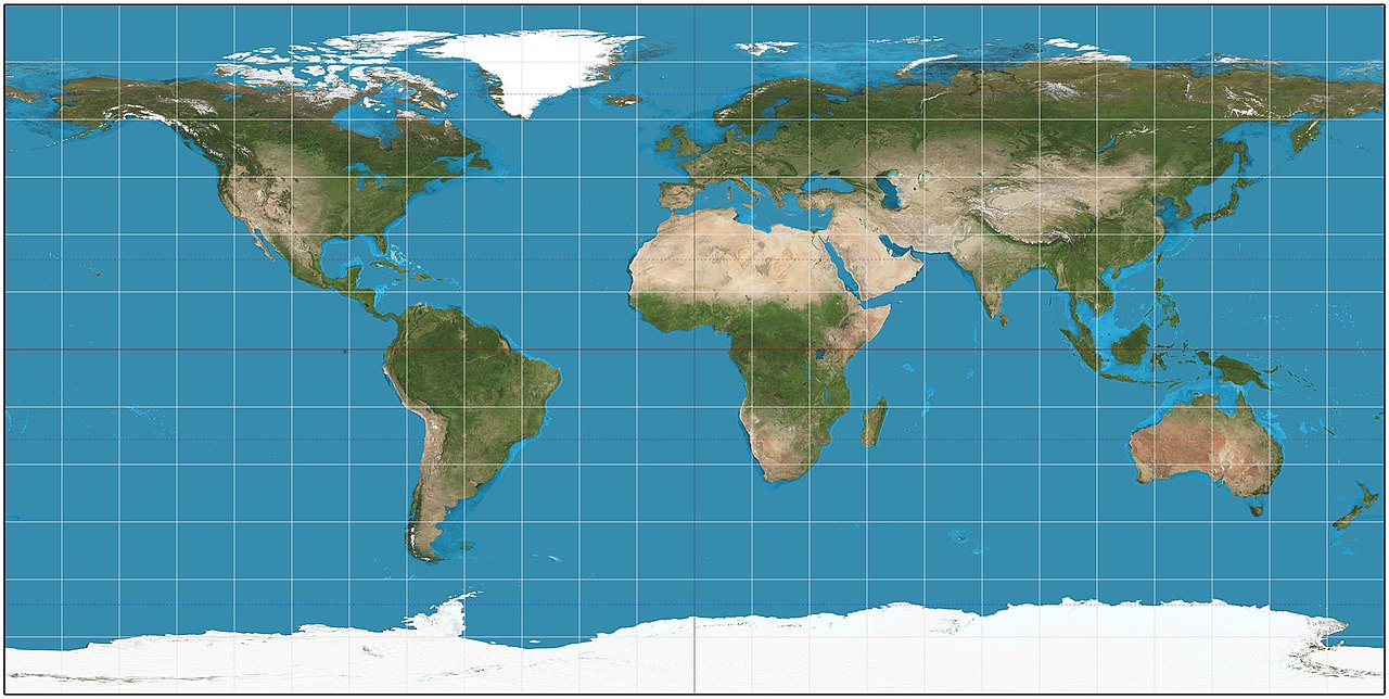
The equirectangular projection, often called the geographic projection or equidistant cylindrical projection, is one of the simplest ways to represent Earth (or another sphere) on a plane. It places meridians as vertical straight lines and parallels as horizontal straight lines, with both sets evenly spaced. That direct mapping of longitude to x and latitude to y makes the projection easy to compute and to interpret visually, but it also creates strong distortion away from chosen standard latitudes.
Image gallery
4 Images


Characteristics and variants
Key features include:
- Meridians and parallels are straight and form a rectangular grid.
- The projection is neither conformal (it does not preserve local angles) nor equal-area (areas are distorted, increasing toward the poles).
- Scale is true along one or two chosen parallels (the equator in the common special case), but changes with latitude elsewhere.
- The plate carrée is a special case in which longitudinal and latitudinal degrees are plotted with the same linear scale, making the grid spacing equal in both directions.
How it is defined
Conceptually the projection maps geographic coordinates directly to Cartesian coordinates: longitude controls the horizontal position and latitude controls the vertical position. Variants permit choosing a standard parallel where scale is preserved. Because of this straightforward rule, the equirectangular form is a convenient format for storing global raster datasets and for quick visualizations, though it is not suitable where metric accuracy is required.
History and development
Simple rectangular mapping of latitude and longitude dates back to classical geography and early mapmakers. Cartographers such as Marinus of Tyre and Claudius Ptolemy in the early centuries AD used related rectangular graticules to organize place coordinates and compile world maps; see ancient cartography for background. The modern terminology and analysis of projections developed much later as mathematical cartography advanced.
Uses and examples
Despite its distortions the equirectangular projection is widely used in digital and applied contexts because of its simplicity:
- Raster storage and basic web mapping where fast, uniform indexing of latitude–longitude cells is useful.
- Panoramic photography and spherical environment maps: many 360° images are encoded in equirectangular form for display and processing (panoramic formats).
- Texture mapping in computer graphics, where a picture must be wrapped around a sphere or sky dome.
It is also used as an educational tool to show the global grid of latitude and longitude because the graticule is depicted as a simple rectangular network.
Limitations and notable distinctions
The projection should not be used for navigation or for tasks needing accurate bearings or areas. Distortion of shapes and sizes grows with latitude, so regions near the poles appear highly stretched. For navigational needs, conformal projections such as Mercator are preferred; for area-preserving displays, equal-area projections are used. For more technical definitions and variants, see discussions of the equidistant cylindrical family and the plate carrée variant (projection variants).
Related articles
Author
AlegsaOnline.com Equirectangular projection Leandro Alegsa
URL: https://en.alegsaonline.com/art/31830