Navigation: methods, history, and modern systems for finding position and route
Overview of navigation: techniques to determine position and plan routes across sea, air and land. Covers traditional methods (compass, celestial, dead reckoning), modern GNSS/GPS, instruments, and safety considerations.
Navigation is the set of techniques, instruments and practices used to establish position, determine direction, and plan or follow a route. When visible reference points exist, people navigate by sighting landmarks; such visual cues are often called landmarks. In many environments, however, navigation relies on instruments, charts and sensors that remove the need for continuous visual contact with terrain.
Image gallery
10 Images


Core methods and instruments
Traditional methods include compass use, map and chart reading, dead reckoning (estimating position from known course and speed), and celestial navigation using the sun, moon and stars. Tools developed over centuries — magnetic compasses, astrolabes, sextants and precise timekeepers — made long-distance navigation practical. Modern instruments include gyroscopes, inertial measurement units and electronic displays that integrate multiple data sources.
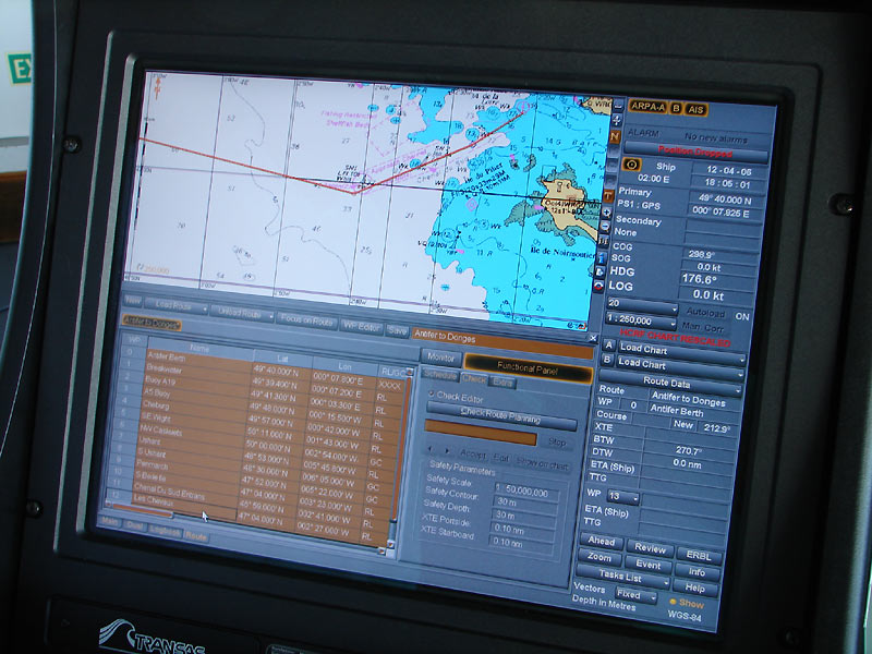
Electronic and satellite navigation
Since the late 20th century satellite systems have become central to many users. The Global Positioning System and other global navigation satellite systems provide continuous positioning and timing data that are routinely combined with digital maps, radar and radio aids. Because reliance on satellites creates vulnerabilities, navigators train in backup techniques and use augmented and alternative systems to improve accuracy and reliability. See the principal system, the Global Positioning System, for technical and operational details.
Maritime navigation
Navigation at sea emphasizes safe routing, collision avoidance, passage planning and handling of tides and currents. Mariners use nautical charts, compass bearings, electronic chart systems, radar, and visual aids such as buoys and beacons to guide ships. Traditional seamanship, including knowledge of tides and pilotage near coasts, remains important even with modern electronics.
Aviation navigation
Aviation navigation operates in three dimensions and within regulated airspace. Pilots use a combination of radio navigation aids, instrument procedures, flight management systems and onboard sensors to fly routes and conduct instrument approaches. Many navigation terms and practices in air transport reflect the discipline’s precise regulatory and safety requirements for aircraft operations.
Land navigation and wayfinding
On land, navigation ranges from pedestrian wayfinding and orienteering to vehicle routing and logistics. Map reading, compass use and terrain association remain fundamental skills for hikers and rescue teams, while consumer turn‑by‑turn systems and digital mapping services guide drivers and delivery operations.
History, language and practice
The term navigation has roots in words for ships and seafaring in Indo‑European languages and historically focused on maritime practice; over time the sense expanded to mean finding one’s way in any environment. Advances such as the magnetic compass, accurate timekeeping and radio navigation each reshaped the field and enabled longer, more reliable journeys. For language history and related terms see comparative etymology.
Reliability, regulation and future trends
Reliability and safety drive the way navigation is taught and regulated. Maritime and aviation authorities require standardized charts, procedures and redundancy of methods. Emerging trends include autonomous navigation for vehicles and vessels, improved sensor fusion, and resilience measures against signal interference or denial. Practitioners continue to balance modern convenience with core skills—such as dead reckoning and celestial fixes—that serve as dependable fallbacks.
- Navigation vs orientation: Navigation implies planning a route; orientation is knowing current heading or bearing.
- Cross‑domain tools: Technologies such as inertial systems and SLAM-based sensors are used in multiple domains.
- Legal and safety context: Conventions and regulations shape navigation in professional settings.
For introductory resources and specific topics consult materials on landmarks, maritime practice for ships, avionics and procedures for aircraft, comparative language studies at etymology sources, and technical references for the Global Positioning System.

Basics
The activity of navigating consists of three parts:
- Determine geographic position by locating using various methods,
- Calculate the optimal path to the destination and
- Guiding the vehicle to this goal, i.e. above all maintaining the optimum course, possibly taking drift into account.
Subtasks 2 and 3 require the ability to maintain traffic even under difficult conditions (e.g. in fog, danger of ice or thunderstorms) and to exclude any possibility of collision with other vehicles. Navigation therefore also includes the technology and science of being able to re-optimise the route en route in addition to locating it, as well as quickly detecting changes in the attitude and altitude of aircraft and adjusting course/speed accordingly.
The basis of any navigation is visual navigation (spatial awareness and visual control) and coupling (path calculated from the course), but today supplemented by methods of radio or satellite navigation. The latter allows even with cheap handheld devices under 100 € an accurate location determination to about 10-20 meters.
Until about the year 2000, however, dead reckoning was the most important method - calculating or estimating the distance travelled by means of course and speed (or, in the case of larger aircraft and rockets, also by means of acceleration). The longer the distance or the more complicated the route, the more this navigation (which is usually unconscious in the case of pedestrians or car drivers) must be supplemented by position measurements en route. Because even with good compasses etc., the coupling accuracy is limited to 1-3 percent of the distance covered at best, but can also deviate by 10 percent from the assumed ("gissten") course due to crosswinds and ocean currents.
Basic methods
Most navigation methods originate from nautical science, i.e. the determination of the location and control of ships. The classical aids of localization are of a geometric nature (angle measurement and direction measurement) as well as the determination of intrinsic speed and distances. They have been used for centuries in the following method groups:
- visual navigation: finding your way around the coast by memory and simple coastal or nautical charts ("portolanes")
- terrestrial navigation: the determination of the location near the coast on the basis of landmarks (prominent points on land) and occasional lighthouses. Sounding (determining the depth of the fairway) is also part of this. Today, these proven methods are supplemented by densely marked harbour entrances, various navigation marks and radio beacons.
- Dead reckoning: the continuous determination of position from course and speed. The course can be determined with the sun, celestial bodies and (since the Middle Ages) with the compass, the speed by estimation or with the railing log. To this day, the entry in the log book is supplemented by graphically adding up the distance travelled on the nautical chart. The position determined in this way is known as the "gisster" or dead reckoning and is - depending on the weather - accurate to a few percent (see also Etmal).
- If possible, wind drift is taken into account when coupling; modern aids such as course computers (for wind triangle, radio beacon, etc.) and Doppler radar increase the accuracy to about 0.5% of the distance, and inertial navigation again.
- Astronomical navigation: the determination of location by measuring the angle of elevation to the sun, navigation stars or planets. It complements the three above methods on long distances. The achievable accuracy with Jacob's staff is about 20 km, with modern sextants 1-2 km.
- These methods, which had been tried and tested for centuries, were joined for the first time by radio navigation in 1899 and satellite navigation in 1964 (see next but one chapter).
- Polynesian navigation, which has largely been lost, was based on star path and zenith star navigation, among other things. Together with the observation of waves, wind, animals and clouds, the Polynesians were thus able to find their way even to distant, flat atolls.
Long-range navigation
Long-range navigation (LRN) is the term used in nautics and aviation (long-range flight) to describe the procedures for determining location and controlling vehicles over distances of several 100 km.
The special methods of long-range navigation have today - due to the predominance of GNSS satellite methods such as GPS and GLONASS - receded into the background, but are still necessary for redundantly secured navigation independent of GPS. Until about 1995, it could be said in nautical science that long-range navigation was always required when terrestrial navigation (in the wider visual range of a coast or islands) was no longer sufficient and the destination had to be approached more precisely than about 50 km.
Astronavigation
Astronavigation by means of time and angle measurements to the sun and bright stars is the classic method that has been part of the experience of all navigators since the voyages of discovery by the Polynesians and other seafaring peoples - and is still part of training today. Until about 1970, it was the basis of long-distance navigation in the entire southern hemisphere, but was also used in northern countries for about 10-20% of all location determinations. Since the 1970s, it has been increasingly displaced by radio and satellite methods in the south as well (see below), but is still necessary today for small ships and for emergencies (power failure, etc.).
Radio navigation
Important in radio navigation are
- LORAN (LOng RAnge Navigation) should be mentioned (in addition to the older LORAN-A (medium waves), especially LORAN-C (a hyperbolic method based on time-of-flight measurement with long waves)). Although it often suffers from poor coverage in remote regions, it has become significant again in the last decade due to technical modernization and signal processing. The Federal Radionavigation Plan 1994 and the EU had already considered phasing out LORAN, but its importance as a backup in curved flight and in case of GPS or Galileo failures was recognized in time.
- Between about 1975 and 1995 there was also the world-wide OMEGA system, which, because of the use of longitudinal waves, managed with only 8 transmitting stations, the operation of which, however, became too expensive despite international cooperation, or was rendered superfluous by the advent of GPS.
- Other - more regional - methods such as the Russian Alpha (a LORAN equivalent), the British Decca, the post-World War II NavaRho and others.
Satellite navigation
→ Main article: Satellite navigation and satellite positioning service
- From about 1960, the US Navy's transit NNSS system (5-6 polar orbiting navigation satellites), which was released for all civilian uses in 1963/1964 and remained available until the late 1990s,
- and, since about 1990, the Global Positioning System (GPS) of the US Department of Defense. Its simple version (CA code), which has been in civilian use since its beginnings, is sufficient for 99% of long-range positioning tasks. The number of satellites (20,200 km high) increased over time from 5-10 to about 30 and provides worldwide coverage with 5-8 simultaneously measurable satellites (4 are necessary).
- Furthermore, the GLONASS (Russian/English GLObal NAvigation Satellite System), which was developed by the Soviet Union and is similar to GPS.
- and, from 2012-2015, the European Galileo system, which will significantly improve the GPS methodology and make it even more widely usable.
Special procedures
Last but not least, special methods such as meteorological navigation, magnetics, polar navigation or depth measurement (echo sounder, etc.) should be mentioned for special tasks on long distances. In antiquity and in the early days of the great "Age of Discovery" (14th-16th centuries), the method of lunar parallaxes and observation of natural phenomena such as bird flight, drifting grasses, dead wood, seaweed, etc. were also important. Also useful for finding the way across the Atlantic or Pacific were approximately known ocean currents or wind systems (trade winds!).
Today's navigation methods
In addition to the 3 classic methods (see above), others were added over time. Today, one generally distinguishes 7 groups of methods and, as the eighth, their optimal combination:
- Terrestrial navigation involves determining position near the coast using landmarks (prominent points on land), radio beacons and other navigation marks.
- Visual navigation is based on the comparison of the map and the terrain (coastal shape, capes, coastal places).
- Astronomical navigation locates the position by measuring the direction and altitude of celestial bodies (sun, planets or fixed stars).
- Dead reckoning is the continuous determination of position from heading and speed. The position determined in this way is called the dead reckoning or gybed (assumed) position. By calculating or directly observing the drift, the lateral displacement caused by the wind is taken into account; Doppler radar and inertial navigation increase the accuracy from a few percent to about 0.2 percent of the distance covered.
- Radio navigation uses transmitting stations whose radio signals produce geometric locations for one's own position (straight lines, circles and hyperbolas).
- Inertial navigation allows autonomous navigation by using accelerometers and gyroscopes.
- Satellite navigation (see also GPS, GLONASS and Galileo) uses signals from 4-6 simultaneously visible satellites, from whose transit times to the location of a receiver its position can be calculated.
- Integrated navigation or hybrid navigation combines several of these methods and weights them according to their quality. The position optimally calculated in this way allows statements to be made about their accuracy and reliability ("integrity").

Questions and answers
Q: What is navigation?
A: Navigation is the process of determining one's location and finding a way to reach another place.
Q: Where did the word navigation come from?
A: The word navigation comes from the Latin word navis, meaning "ship".
Q: What is the literal meaning of navigation?
A: The literal meaning of navigation is "art of ship mastery".
Q: Is navigation limited to ships and aircraft?
A: While navigation is often associated with ships and aircraft, it can also be used for finding one's way in any context.
Q: When was navigation invented?
A: Navigation was invented in the 15th century.
Q: What is the main tool for navigation?
A: The Global Positioning System (GPS) is the main tool for navigation.
Q: Why is navigation easy when landmarks are visible?
A: Navigation is easy when landmarks are visible because they can help someone determine their location and find a way to another place.
Related articles
Author
AlegsaOnline.com Navigation: methods, history, and modern systems for finding position and route Leandro Alegsa
URL: https://en.alegsaonline.com/art/68852