Circle of latitude
A circle of latitude is an east–west ring on the globe joining points with the same latitude; it structures maps, climate zones and navigation and includes the Equator, tropics and polar circles.
Overview
A circle of latitude is an imaginary line encircling the Earth in an east–west direction that links every location sharing the same latitude. These lines are commonly called parallels because each one runs parallel to the others and to the Equator. A point's position along any parallel is specified by its longitude; for example, travel east or west to change longitude while staying on the same parallel. Latitude and longitude together form the geographic coordinate system used to locate places on maps and charts (latitude, longitude).
Image gallery
3 Images

Geometry and measurement
Latitude is measured in degrees north or south of the Equator (0°) up to the poles at 90°N and 90°S. On an idealized sphere, each parallel is a true circle whose circumference decreases with latitude according to the cosine of the latitude. Only the Equator is a great circle; every other parallel is a small circle. On the real, slightly flattened Earth there are small differences between geodetic and geocentric latitude, but the basic parallel concept remains valid for mapping and navigation.
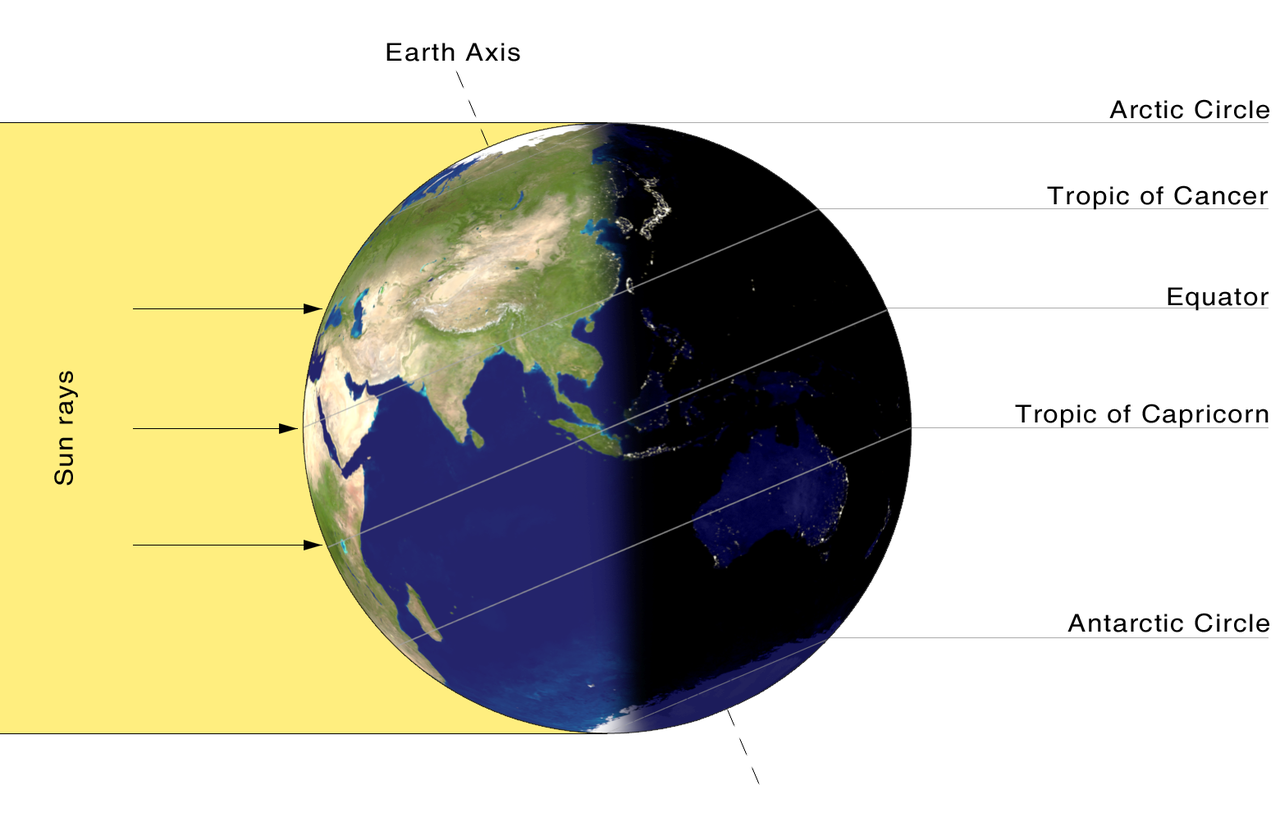
Major circles and climate zones
- Arctic Circle (~66.5°N) — marks the region that can experience 24-hour daylight or darkness.
- Tropic of Cancer (~23.5°N) — northern limit where the Sun can be directly overhead.
- Equator (0°) — the widest parallel, dividing northern and southern hemispheres.
- Tropic of Capricorn (~23.5°S) — southern counterpart to the Tropic of Cancer.
- Antarctic Circle (~66.5°S) — southern zone of polar day and night.
Uses and significance
Parallels are fundamental to cartography, navigation, climate classification and astronomy. They help define time zones and climatic belts (tropics, temperate zones, polar regions). Mariners and aviators use latitude with longitude to plot courses; scientists use parallels to analyze temperature, precipitation and daylight patterns. The positions of the tropics and polar circles are tied to Earth's axial tilt and thus to seasonal solar geometry.
Distinctions and notable facts
Unlike meridians (lines of longitude), which all converge at the poles, parallels never meet and remain equidistant in angular terms. The length of a degree of latitude along a meridian remains nearly constant, while the length of a degree of longitude varies with latitude. Historical mapmaking, exploration and the development of global navigation all relied on an accurate understanding of parallels and their interaction with longitude.
Related articles
Author
AlegsaOnline.com Circle of latitude Leandro Alegsa
URL: https://en.alegsaonline.com/art/20443