
Saint Anthony Falls
Historic waterfall on the Mississippi River at Minneapolis, once the only large natural falls on the upper river; key to regional geology, indigenous use, and 19th‑century industrial development.
Overview
Saint Anthony Falls sits on the Mississippi River at the east edge of downtown Minneapolis and for centuries was the only significant natural waterfall on the Upper Mississippi. The falls gave their name to the surrounding community and helped determine the location of bridges, mills and later urban development. The general location is described on many modern maps and guides: see the local location reference map and a municipal overview city site.
Image gallery
10 Images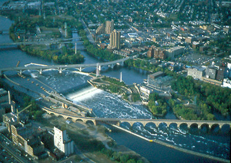


Formation and physical characteristics
The falls were created and shaped during the end of the last Ice Age, when glacial meltwaters and the shifting course of rivers sculpted the riverbed and left a limestone and sandstone ledge that produced a vertical drop. Over thousands of years the falls migrated upstream by erosion. The original natural crest and plunge pool no longer exist in their pristine form, but geological accounts and museum displays summarize this origin; a compact geological summary is available via regional geology.
History and industrial development
Indigenous peoples long used the falls as a fishing and meeting place; later Euro‑American settlers recognized the site for its hydropower potential. In the 19th century the waterpower of Saint Anthony Falls attracted sawmills and, notably, large flour mills that helped make Minneapolis an international milling center. The industrial complex around the falls expanded rapidly, with canals, raceways, and mills built to harness the drop. For a brief guide to the area's industrial heritage consult heritage resources.
Collapse, engineering response, and modern management
In 1869 a catastrophic failure of a wooden apron and underlying sediments caused a breach that threatened to erase the falls entirely. Engineers and city officials responded with emergency works and later with permanent structural solutions: cribwork, stone and concrete aprons, and a managed spillway that now controls flow and protects the remaining face. These interventions stabilized the site and allowed continued industrial and urban use while preserving a historic riverfront. For details on preservation and management see preservation overview.
Contemporary importance and access
Today the falls area is a mix of historic industrial landmarks, recreational trails, and interpretive sites. Visitors can view the river and the engineered spillway, walk along riverfront trails, and cross the nearby historic Stone Arch Bridge that frames views of the cascade. The site illustrates intersections of geology, technology and urban planning and remains a focal point for Minneapolis riverfront revitalization.
Notable distinctions
- Historically the only large natural waterfall on the Upper Mississippi.
- Central to Minneapolis' rise as a milling center in the 19th century.
- Subject to major 19th‑century engineering work after partial collapse.
- Now protected and interpreted as part of the city's cultural and recreational landscape.
Author
AlegsaOnline.com Saint Anthony Falls Leandro Alegsa
URL: https://en.alegsaonline.com/art/145279