
Zaporizhia
Major industrial and cultural city on the Dnieper in southern Ukraine, known for Khortytsia Island, hydroelectric power, and its role as the administrative center of Zaporizhia Oblast.
Overview
Zaporizhia (also spelled Zaporizhzhia, Russian Zaporozhye) is a principal city in southern Ukraine on the banks of the Dnieper River and the administrative center of Zaporizhia Oblast. It developed into a major industrial and transport hub during the 20th century and serves as a regional center for education, culture and commerce. Population estimates have varied; mid-2010s figures commonly cited put it at roughly 760,000 residents.

Image gallery
10 Images


Name and historical background
The city’s name derives from a Ukrainian phrase meaning "beyond the rapids," referring to stretches of the Dnieper that historically impeded river navigation. The surrounding region is closely associated with the Zaporizhian Cossacks and the historic Sich that existed on islands and riverbanks in the area. A modest settlement in the late imperial period expanded rapidly in the Soviet era when large-scale industrial projects and electrification programs transformed the local economy and urban landscape.
Geography and notable sites
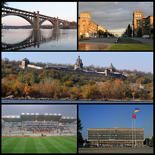
Zaporizhia occupies both banks of the Dnieper where the river widens and includes several islands; the largest and most famous is Khortytsia, a long island with archaeological remains, open-air museums, and a national park. The city is also known for the Dnieper hydroelectric complex and associated dam and power station that regulate river flow and supply electricity to industry. These features shape both the skyline and the surrounding environment.
Economy and infrastructure
The city’s economy is characterized by heavy industry: metallurgy, machine-building, and energy production are prominent sectors. Large enterprises produce steel, heavy machinery, and components for aviation and manufacturing. Zaporizhia functions as a key transport node with river ports, railway connections and major road links that serve domestic and regional trade.
Culture, education and civic life
Zaporizhia hosts universities, professional institutes, theaters, museums and cultural centers that reflect the region’s industrial and Cossack heritage. Museums on Khortytsia, local history collections, and performing arts venues form the backbone of its civic life. Urban planning and public projects in recent years have focused on improving infrastructure, environment and educational capacity.
Distinctive facts and administration
As the oblast capital, Zaporizhia is the seat of regional government and local municipal authorities. It has multiple accepted romanizations (Zaporizhia, Zaporizhzhia, Zaporozhye) reflecting Ukrainian and Russian-language usage. Contemporary municipal strategies have addressed economic diversification, environmental protection around the Dnieper, and modernization of public services.
Quick reference
- Location: Southern Ukraine on the Dnieper River
- Region: Zaporizhia Oblast (administrative centre)
- Notable features: Khortytsia Island, hydroelectric complex, industrial enterprises
Geography
The city is located in the north of Zaporizhzhya oblast. The distance to Kiev is 444 km as the crow flies, to Dnipro 70 km. South of the city, the Dnieper River is dammed to form the 2155 km² Kakhovka Reservoir.
The agglomeration of the city, starting from the east and following clockwise, are the settlements in Zaporizhzhya rayon Natalivka, Rostushche, Novooleksandrivka, Balabyne, Rosumivka, Baburka, Novoslobidka, Vysokohirne, Sonyatshne, Volodymyriivske, Prydniprovske, and the villages of Vilnoandriivka, Bohatyriivka, Lyuzerna, Matvyivka, and Kamyane, located in the Vilniansk Rajon, all of which are directly adjacent to the built-up area of Zaporizhzhya.
City breakdown
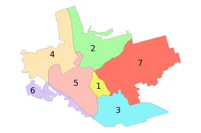
The urban area of Zaporizhzhya consists of 7 rajons. These are:
| Number | Rajon | Inhabitants (November 2015) |
| 1 | Oleksandrovsk Rajon | 68.666 |
| 2 | Savod Rajon | 50.750 |
| 3 | Komuna rayon | 133.752 |
| 4 | Dnipro Rajon | 135.934 |
| 5 | Vosnessenivka Rajon | 101.349 |
| 6 | Khortytsia Rajon | 115.641 |
| 7 | Shevchenko Rajon | 151.558 |

Climate
It has a temperate continental climate with mild winters (average temperatures around freezing) and warm (sometimes hot) summers with maximum temperatures above 25 °C. The average annual temperature is 9.4 °C. The coldest month is January with an average temperature of -3.1 °C, the warmest month is July with an average of 22.5 °C. However, a lot of precipitation must be expected, especially in June.
| Climate diagram
Source: , | |||||||||||||||||||||||||||||||||||||||||||||||||||||||||||||||||||||||||||||||||||||||||||||||||||||||||||||||||||||||||||||||||||||||||||||||||||||||||||||||||||||||||||||||||||||||||||||||||||||||||||||||||||||||||||||||||||||||||||||||||||||||||||||||||||||||||||
Related articles
Author
AlegsaOnline.com Zaporizhia Leandro Alegsa
URL: https://en.alegsaonline.com/art/110398