Dnipro — major Ukrainian city on the Dnieper River
Dnipro (formerly Dnipropetrovsk) is a major industrial and cultural centre in central-eastern Ukraine, known for metallurgy, aerospace and defence industries, riverside setting and role as an oblast capital.
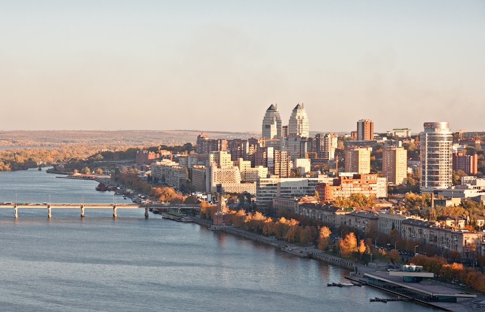
Dnipro (Ukrainian: Дніпро, Russian: Днепр) is a large city in central-eastern Ukraine, located on the banks of the Dnieper River. The city is an administrative, industrial and cultural centre and the capital of its oblast. It is commonly described as having a population of around one million people and lies to the southeast of the national capital, Kyiv. The city's contemporary name replaced the Soviet-era name Dnipropetrovsk in 2016 as part of a decommunization process.
Image gallery
5 Images


Location and geography
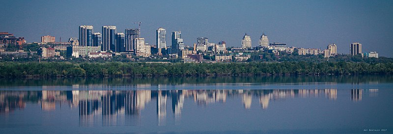
Dnipro occupies both banks of the Dnieper and has a prominent riverside profile with quays, promenades and several bridges connecting districts. The surrounding landscape is part of the Pontic steppe; fertile plains and transport corridors link the city with other industrial and agricultural regions of the country. The river has long influenced urban layout, economic activity and recreational space.
History
The modern settlement traces its formal founding to the late 18th century, with substantial growth during the 19th and 20th centuries as industrialisation expanded in the region. In the Soviet period the city developed heavy industry, engineering and specialised manufacturing. After independence in 1991 Dnipro retained much of this industrial base while expanding education, research and cultural institutions.
Economy and industry
Historically the city has been associated with metallurgy, machine building and high-technology manufacturing. During the Soviet era Dnipro became a major hub for aerospace and defence; a number of design bureaux and production plants known for rocketry and space-related equipment were based in the city and its environs. One of the better-known enterprises linked to that heritage is the large machine-building and rocket-production complex often referred to in English-language sources as Yuzhmash. The city also hosted engineering work relevant to the nuclear sector, particularly in component manufacture and specialist services.
Culture, education and institutions
Dnipro hosts universities, technical institutes and research organisations that serve the wider region. Cultural life is anchored by theatres, museums and galleries, and the city functions as an educational and administrative hub. Public parks and riverfront leisure areas are important to local quality of life, and the city maintains historical monuments and civic architecture reflecting its layered past.
Transport and infrastructure
Transport links include regional rail connections, an airport serving domestic and limited international routes, an urban tram and bus network, and river transport on the Dnieper. Road and rail corridors support freight traffic tied to industry and logistics. Bridges across the river are key urban arteries.
Climate
The climate of Dnipro is often described as bordering between semi-arid and warm-temperate types in the Köppen classification; summaries use categories such as BSh and Csa. Practically, this translates into warm, sunny summers and cool winters with moderate precipitation; local observers frequently note the relatively high number of sunny days. For general climate summaries see climate references.
Strategic importance and further reading
Because of its industrial specialisations, Dnipro was one of the key centres for aerospace, defence and related engineering within the former Soviet Union. It retains significant engineering capacity and research expertise. For general municipal information and statistics consult the city's official and regional resources and compiled city profiles: see the city overview here and broader national summaries here.
- Former name: Dnipropetrovsk until 2016.
- Major industries: metallurgy, machine building, aerospace and defence engineering.
- Geographical note: situated on the Dnieper River within the Pontic steppe zone.
- Administrative role: capital of its oblast and a regional transport and education hub.

Geography
enlarge and show information about the picture
![]()
Panorama of the city
Location
Due to an inconsistent definition, the city is (historically) often counted as part of eastern or southern Ukraine. Geographically, however, it is most likely located in central Ukraine, but with a discernible tendency towards the south and east. The city is located in the central part of Dnipropetrovsk oblast, which is one of Ukraine's 24 oblasts.
Dnipro is located on three sides of the mouth of the Samara River into the Dnieper River, which runs through the city, and on average 155 m above sea level. The Dnieper flows from the Kamiansk Reservoir in a southeasterly direction through the city, changes its course in the city area in a southerly direction and continues to flow in the direction of Zaporizhzhya. With about one million inhabitants, Dnipro represents the largest city on the Dnieper River downstream from Kiev. Within the city the width of the river is about 900 m to 2.5 km.
The land around the city is mostly flat and easy to settle, which also explains why the city has managed to become the fourth largest in Ukraine in only about 200 years of existence. Most of the residential, commercial, and industrial areas, as well as the city center, are located on the right bank of the Dnieper River, which is not as marshy as the left bank. There, however, it has now also been possible to settle large areas (districts: Amur-Nizhnyodnipro rayon, Industrial rayon and parts of Samara rayon). The city area has a surface of 405 km² and extends over 22 km in north-south and 33 km in east-west direction. The highest elevation of the city is 188 m above sea level and is located in a forest area in the southwest of the city, the lowest elevation is the water level of the Dnieper River at 52 m above sea level.
Major cities in the vicinity are Zaporizhzhya, Kryvy Ryh, Kamianske, Kremenchuk, Poltava and Pavlohrad. The coast of the Black Sea and the Sea of Azov are about the same distance.
| Kiev (404 km) | Poltava (137 km) | Kharkiv (190 km) | ||
| Kremenchuk (147 km) | Novomoskovsk (27 km) | |||
| Kropywnyzkyj (212 km) | Kamjanske (35 km) |
| Pavlohrad (75 km) | Luhansk (310 km) |
| Krywyj Rih (140 km) | Zaporizhzhya (65 km) | Donetsk (200 km) | ||
| Odessa (396 km) | Mykolayiv (285 km) |

Distance information refers to the distance (as the crow flies) to the town centre.
Dnipro agglomeration
About 1.68 million people live in the Dnipro agglomeration. It is the second largest in Central Ukraine after the Kiev agglomeration and the fourth largest in Ukraine after the Kiev, Kharkov and Donetsk agglomerations. The agglomeration includes the districts of Dnipro, Mahdalynivka, Novomoskovsk, Synelnykovsk, Solon, Krynychky and Petrykivka, as well as the independent cities of Kamianske, Verkhnyodniprovsk, Vilnohirsk and Synelnykovsk.
Geology
The city is located in the Eastern European Plain in the southeast of the Ukrainian Shield at the junction of the Prypyat-Dnepr-Donetsk Rift.
The crystalline basement consists mainly of Middle Archean granite and migmatite, with layers of biotite gneiss and amphibolite below.
The city core with the Dnipro Old Town is located in the right-bank part of the city, which is partly on the Dnieper Highlands, while the left-bank parts of the city are in the Dnieper Lowlands. A hill in Samara rayon, which is a part of the Azov highlands, causes a change in the flow direction of the Dnieper to the south.
In the city area there are several islands and peninsulas, the most noteworthy is the Monastery Island. Between the right bank of the Dnieper River and the Monastery Island is the Bishop Channel, a 1850-meter-long branch of the Dnieper River. In addition, there are the Dnieper islands Green Island ⊙48.48666735.037778 (ukr. зелений острів), Shevsky Island ⊙48.45666735.099444 (ukr. острів Шевський), Olexiyivsky Island ⊙48.44861135.1075 (ukr. Олексіївський острів) and the Kosa Spit ⊙48.4313835.080833 (ukr. Коса) and the Feinberg Peninsula ⊙48.49166735.014444 (ukr. Півострів Файнберга) in the city area.
Climate
The Dnipro region has a Mediterranean climate with mild (sometimes cold), mostly wet winters and warm dry summers. Less frequently, a semi-arid steppe climate prevails. Thus, the climate is similar to those of, for example, Redding (California) or Reno (Nevada) but has comparatively more rainy days and more precipitation, which means that rain showers are on average smaller. The rainfall distribution is typically Mediterranean with high rainfall in the winter months and low in the summer months. The summer months of June, July and August are almost rainless.
The urban microclimate is significantly influenced by the Dnieper River, near which the humidity increases. Humidity rises in October and reaches over 80% between November and March. Temperatures are cooler, with an annual average of 10.9 °C, cold winters (0 to -4 °C in January) and the highest frequency freeze (74 days per year on average). Snow falls an average of 41 days per year, but heavy falls are rare. Summer is hot, although tempered by the city's altitude (daily maximum temperatures average around 28 °C). The highest temperature ever recorded (of 40.9 °C) was in 1950 and the coldest (of -30.0 °C) in 1955. The average temperature increased by 1.0 °C during the last century.
The average wind speed corresponds to wind force 3 and only in February 4 on the Beaufort scale and is highest between December and April with more than 5 m/s and between May and October with less than 5 m/s. The wind speed is lowest in July and highest in February. The wind speed is lowest in July and highest in February.
The most pleasant months to travel are May and mid-September to mid-October. The months of June to August can be very hot. The mild climate favors viticulture.
| Dnipro | ||||||||||||||||||||||||||||||||||||||||||||||||
| Climate diagram | ||||||||||||||||||||||||||||||||||||||||||||||||
| ||||||||||||||||||||||||||||||||||||||||||||||||
| Monthly average temperatures and precipitation for Dnipro
Source: | ||||||||||||||||||||||||||||||||||||||||||||||||||||||||||||||||||||||||||||||||||||||||||||||||||||||||||||||||||||||||||||||||||||||||||||||||||||||||||||||||||||||||||||||||||||||||||||||||||||||||||||||||||||||||||||||||||||||||||||||||||||||||||||

History
→ Main article: History of the city of Dnipro and History of Ukraine
From Antiquity to the Early Modern Period
A first settlement of the area around Dnipro took place already in the Paleolithic. Many different cultures followed, including the Tripolje culture, the Kurgan culture, the Yamnaya culture, the Scythians and the Sarmatians.
Proto-Bulgarians also passed through here in the course of the migration of peoples, before the area around the city belonged to the Jewish Khazar Empire and the trade network of the Radhanites around 750. Around 900 AD, Magyars tributary to the Khazar Empire came to the area, making the area around the Dnieper and Samara a possible candidate for Etelköz. Due to pressure from the Pechenegs and the Bulgarians allied with them under Tsar Simeon I, the Magyars moved on to the Pannonian Basin.
From about the 8th to the 11th century, the trade route between Scandinavia and Byzantium, one of the most important trade routes in Eastern Europe, ran through the present-day city area via the Dnieper River.
After the dissolution of the Golden Horde, the area around Dnipro was settled in the 15th and 16th centuries by Ruthenians who had fled from Poland-Lithuania, who founded free Cossack communities and in time formed a state (see also Zaporozhian Cossacks). The Cossacks fought against Polish rule and resisted frequent raids by the Tatar Crimean Khanate. To oppose the Cossacks and to discourage resident peasants from joining the Cossacks, the Poles built Kodak Fortress in 1635 about 10 km south of the present town. In the very year of its construction it was captured and burned down by Cossacks under Ivan Sulyma. In 1639 the fortress was rebuilt by the Poles in double size. Under its protection, more and more people settled in the emerging town of Stari Kodaki instead of joining the Zaporozh Cossacks. In the course of the Khmelnytsky Uprising in 1648, the fortress was besieged for seven months, after which it surrendered to the Cossack troops. It was razed by the Russians on the basis of the Peace Treaty of Pruth in 1711. The settlement of Stari Kodaki is considered the predecessor of the city of Dnipro, because it is considered the first fortified and permanent settlement in the area.
Ekaterinoslav
After the Russo-Ottoman War of 1768 to 1774, when the influence of the Ottoman Empire north of the Black Sea was eliminated, a comprehensive development program for the newly conquered southern territories was laid out as part of Empress Catherine the Great's so-called Greek Plan. Under the leadership of Prince Grigory Potyomkin, the Governorate of New Russia was created, whose capital became Ekaterinoslav, founded in 1776. However, the location of the city on the territory of present-day Pidhorodne at the confluence of the Samara and Kilchen rivers (Ukr. Кільче'нь) was unfavorable, as rising spring water regularly turned the city into a swamp. Therefore, the city was moved to its present location.
On 9 May 1787, the foundation stone was laid in the presence of Catherine II and Emperor Joseph II. The Tsarina had travelled from Kiev with a flotilla of 80 ships to found the centre of a "New Russia"; the new city was destined to become a "Petersburg of the South" and an "Athens of the North". In 1805 it had 2634 inhabitants (of whom 376 were Jews). From 1802 to 1925 it was the capital of the Ekaterinoslav governorate.
In the 19th century Ekaterinoslav became a center of industrialization after the city was connected to the rapidly expanding railway network. In 1884, as part of the construction of the railway line from central Russia to the Crimea, the double-decker railway bridge over the Dnieper River was completed. In 1887 the Alexander Ironworks, a steel and rolling mill, went into operation (today: Metallurgical Plant Petrovsky), which at times employed 30,000 workers, in 1889 the pipe mill of the Belgian joint-stock company Ch. & H. Chaudoir (Liège), plus later the Chaudoir-B plant (after 1917: Comintern), in 1895 the foundry of Johann Jakob Esau & Co. (after 1917: Woroschilow combine factory) as well as the Gantke rolling mill (after 1917: Karl Liebknecht) and the railway repair workshops (after 1917: Kirov works).
The population grew rapidly, increasing tenfold from 1860 to 1900. A third of them were Jews, and a strong Jewish workers' movement developed. In 1883 and 1906 anti-Semitism erupted in Jewish pogroms.
Revolutionary period
In November 1917, after the February Revolution, the city, like the entire Ekaterinoslav Governorate, belonged to the Ukrainian People's Republic. However, already on January 9, 1918, units of the Bolsheviks marched in and captured the city. They annexed it to the Red Republic of Donetsk-Kryvyi Rih until April 1918. From April 1918 the city belonged to the German occupation zone. The Central Rada was dissolved and Pavlo Skoropadsky was appointed hetman of the puppet Ukrainian state.
From January 1919 to June 29, 1919, the city belonged to the Red UkrainianSoviet Socialist Republic and then to the White Movement-controlled territory of White Southern Russia (Rus. бе́лый Юг Росси́и).
The city did not experience any battles or destruction during the years of the Russian Civil War. It was captured twice by soldiers of Makhnovshchina, from December 27 to 31, 1918, and from November 9 to December 9, 1919.The combined forces of the Ukrainian People's Republic and the Ukrainian State, the so-called Petlyurovtsi (rus. петлюровцы) were expelled in 1918. During the affiliation to the Ukrainian People's Republic and the Ukrainian state, respectively, the National Oles Honchar University of Dnipro was founded and the city was renamed Sitzhezlav, but this name was never officially valid and lasted only one year.
In 1919 Dnipro (again called Ekaterinoslav) was the capital of Makhnovshchina, after units of the White Army were expelled. Subsequently, on December 30, 1919, the city was captured by the Red Army, which finally won the Civil War.
The city in the Soviet era
During the Holodomor in 1933, several million people starved to death in Ukraine. During this period, the secret police GPU found many cases of cannibalism. About seven percent of all criminal cases of cannibalism, punishable by at least ten years or the death penalty, originated in Dnipropetrovsk oblast.
See also: Battle of the Dnepr
During the Second World War, the city suffered enormous destruction. In September 1941, Red Army soldiers retreating from Wehrmacht troops blew a 200-metre breach in the dam wall and the 65 km long reservoir ran dry. The Germans had the dam rebuilt; it was finished by the end of 1942. In October 1943 they had to withdraw and bombed the dam from the air. From 1944 to 1950 the dam was rebuilt.
There was a mass murder of Jewish inhabitants by German occupiers. The SS leader Friedrich Jeckeln was significantly involved in the mass shootings. On October 13, 1941, 11,000 Jews were murdered in the process. When in autumn 1941 a famine in the city could no longer be ignored, the Nazi Secretary of State for Food and Agriculture Herbert Backe forbade (according to the "Ereignismeldung UdSSR" No. 135 of the SS-Einsatzgruppe C of November 19, 1941) the introduction of food ration cards, as these "represented legal claims to supply".
The city was home to two POW camps, 417 and 460 (from 1949), for German prisoners of war of World War II. Those who were seriously ill were cared for in the prisoner of war hospital 5905.
After the Second World War, there was reconstruction, further industrialization and rapid population growth, which made Dnipropetrovsk a city of millions in the 1980s.
Independent Ukraine since 1991
In 2007, a series of murders occurred in the city, the perpetrators of which are called Dnepropetrovsk Maniacs. In this case 21 people were killed, mostly defenceless and homeless people. The perpetrators, who were arrested in 2008, were three men aged between 19 and 26 who filmed themselves committing their crimes. They came from good homes and justified their acts by saying that they felt the "thrill" of killing and wanted to have memories of their youth in later life.
On October 13, 2007, there was a gas explosion in a residential building ⊙48.435833333335.0666666667 in the Peremoha district of the Sobor city rayon, killing 22 people.
Shortly before the start of the 2012 European Football Championship, which was also held in Ukraine, several bomb attacks, which were carried out almost simultaneously in busy areas of the city on 27 April 2012 and in which at least 29 people were injured, generated international press coverage. There have been no confessional videos or other communications from the perpetrators, so it is not possible to say in what context this attack was carried out.
Dnipropetrovsk was one of the cities to which the OSCE sent observers on 21 March 2014 due to the war in Ukraine. In the days and weeks before, pro-Russian protests with 1000-3000 participants had taken place in Dnipropetrovsk, including on 1 March 2014, with demonstrators calling for a referendum along the lines of the one in Crimea. On 2 March 2014, a pro-Ukrainian counter-demonstration with around 10,000 participants took place.
History of the city name
In the course of the eventful history of the city, its name was also changed several times. One English nickname is "Rocket City", because the KB Yuzhnoye design office is based there and, among other things, the Dnepr rockets were built there. Most locals call the city "Dnepr" (rus. Днепр, ukr. Дніпро) for short, but this is also understood by most non-natives. There have been repeated efforts to change the name of the city, with both "Sitzheslav" and "Yekaterinoslav" and "Katerinoslav" respectively being suggested.
On 15 May 2015, Ukrainian President Petro Poroshenko signed a law banning communist and Nazi propaganda, which also refers to places and streets contaminated with propaganda in the sense of the law. These were to be renamed within six months. The city then set up a commission to work out a solution. As the name Dnipropetrovsk referred to Grigory Ivanovich Petrovsky, the former chairman of the Supreme Soviet of the Ukrainian SSR, the city was renamed Dnipro on 19 May 2016 by decision of the Verkhovna Rada, after a petition of the Dnipropetrovsk City Council from 2015 to retain the old name but to link the suffix "petrovsk" with St. Peter was rejected.
Timeline of name changes
- Ekaterinoslav/Katerinoslaw 1776-1797
- Novorossiysk 1797-1802
- Ekaterinoslav/Katerinoslaw 1802-1917
- Sitshezlav 1917-1918 (not official)
- Ekaterinoslav/Katerinoslav 1918-1926
- Krasnodniprovsk 1926 (planned; not official)
- Dnepropetrovsk/Dnipropetrovsk 1926-2016
- Dnipro since 2016
Meaning
- Ekaterinoslav (Russian Екатеринослав) or Katerinoslaw (Ukrainian Катеринослав) - means something like "In honor of Catherine".
- Novorossiysk (Russian Новороссийск) - means not "New Russia", but "New Russian settlement/New Russian city" (possibly as a diminutive).
- Sitzheslav (Ukrainian Січеслав, Russian Сичеслав) - roughly means "In honor of Sitzh".
- Krasnodniprovsk (Ukrainian Краснодніпровськ, Russian Красноднепровск) - approximately "Rotdniprovsk", a composition of the color red as a symbol of communism and the Soviet Union and Dnieper.
- Dnipropetrovsk (Ukrainian Дніпропетровськ [ˌdɲiprope̝ˈtrɔu̯sʲk], Russian Днепропетровск/Dnepropetrovsk [ˌdʲnʲeprəpʲɪˈtrofsk]) is the name, given to the city in the Soviet Union in 1926, a compound of the Dnieper River and the name of Grigory Ivanovich Petrovsky, then Chairman of the Supreme Soviet of the Ukrainian SSR.


Related articles
Author
AlegsaOnline.com Dnipro — major Ukrainian city on the Dnieper River Leandro Alegsa
URL: https://en.alegsaonline.com/art/28081
Sources
- dniprorada.gov.ua : "Global city GDP 2011"