Salt Fork Arkansas River
A tributary of the Arkansas River in the central United States, the Salt Fork drains prairie country and supports agriculture, wildlife, and local recreation; its name reflects saline springs and soils in its basin.
Overview
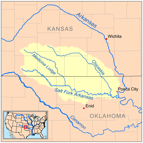
The Salt Fork Arkansas River is a tributary of the Arkansas River in the central United States. It flows across prairie and agricultural landscapes and contributes to the larger Arkansas–Mississippi river system. The name "Salt Fork" reflects natural saline springs and salt-bearing soils historically found in its watershed.
Image gallery
3 Images

Course and characteristics
The river rises on the plains and follows a generally meandering course toward the Arkansas River. Flows are seasonally variable, with higher discharge during spring runoff and after heavy rains. The Salt Fork and its smaller tributaries form floodplains and wetlands that moderate floods and support local groundwater recharge.
Features and typical conditions
- Meandering channel across flat to rolling terrain
- Seasonal flow fluctuations with occasional flooding
- Saline springs or salt-affected soils in portions of the basin
- Riparian corridors that support diverse plants and wildlife
History and origin of the name
Indigenous peoples, wildlife and early explorers were attracted to salt springs and natural salt licks in the region. These features gave rise to names such as Salt Fork, reflecting places where animals and people obtained salt long before industrial sources were available. The river corridor also figured in settlement, ranching and local travel routes.
Uses, ecology and management
Today the Salt Fork basin supports agricultural irrigation, livestock watering, fishing, hunting and other outdoor recreation. Portions of the stream are modified by small impoundments or channel adjustments for flood control and water supply. Management is typically shared among state agencies and local stakeholders, balancing water use, habitat conservation and flood risk reduction.
Further information
For broader context on the region's river network see More on the Arkansas River system. For material on regional water planning and conservation efforts consult Regional water management.
Related articles
Author
AlegsaOnline.com Salt Fork Arkansas River Leandro Alegsa
URL: https://en.alegsaonline.com/art/86541