Acklins and Crooked Islands
Two low-lying Bahamian islands in the southeastern archipelago, formerly administered together; sparsely populated with small fishing communities and a history of salt and plantation-era activity.
Acklins and Crooked Islands are part of the Bahamian archipelago in the Atlantic Ocean, centered near the coordinates 22°30′N 74°0′W. They lie among a chain of cays, shallow banks and lagoons that characterize the southern Bahamas. The two islands are modest in size, largely low-lying and dotted with small settlements, and they have historically supported only small human populations.
Image gallery
1 Image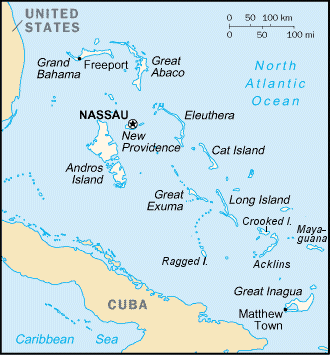
Geography and environment
The islands are formed of carbonate rock with broad tidal flats, mangrove lagoons and sheltered bays. Their shoreline and adjacent shallow banks are important for marine life, providing nursery habitat for fish and invertebrates. Vegetation is typically salt-tolerant coastal scrub, mangrove stands around sheltered inlets, and scattered patches of coppice on higher ground. The landscape is generally flat, with few elevated features.
Administrative history
Administratively the islands have been treated in various ways. They were administered together as a district of the Bahamas under names that changed in the 1990s. They were known as "Acklins and Crooked Islands" until 1996 and were later listed under the combined name "Acklins, Crooked Island and Long Cay" until 1999. Since the reorganization in the late 1990s the two principal islands have been recognized as separate districts within the Bahamian system; further information on that reorganization can be found via contemporary administrative records administrative history.
Population and settlements
The islands have small, dispersed populations. According to the 2000 census, recorded totals were modest: the population of Acklins was listed as 428 and Crooked Island as 350; these figures are drawn from census reporting of that year 2000 census and related demographic summaries population data. Communities are centered on a few villages and harbors that serve fishing and inter-island transport needs.
Economy and uses
Economic activity on Acklins and Crooked Island is largely subsistence and small-scale commercial: fishing, small-scale agriculture, and local services for residents and visiting boaters. Historically, parts of the southern Bahamas were involved in salt raking and plantation agriculture during the 18th and 19th centuries; traces of that era remain in place names and local history, while modern livelihoods are oriented around marine resources and local commerce. Tourism is limited compared with major Bahamian islands but attracts niche visitors seeking remote beaches, birdwatching and sport fishing.
Notable distinctions
- Low population density and small settlements distinguish these islands from the more developed northern Bahamas.
- Their coastal habitats—mangroves, flats and seagrass—support important biodiversity and local fisheries.
- Administrative arrangements changed in the late 1990s; for official details consult government sources administration records or census publications census summaries.
Visitors or researchers seeking up-to-date statistics, maps or governance details should consult current Bahamian government publications or census releases; many online and printed sources provide periodic updates to population and administrative status further information.
Related articles
Author
AlegsaOnline.com Acklins and Crooked Islands Leandro Alegsa
URL: https://en.alegsaonline.com/art/731
Sources
- statistics.bahamas.gov.bs : "PRELIMINARY POPULATION AND HOUSING COUNT BY ISLAND AND SUPERVISORY DISTRICT, ALL BAHAMAS: CENSUS 2010"
- geohive.com : "Bahamas, the - General Information"