
Norbury: district profile in south London
Norbury is a residential district in the London Borough of Croydon, bordering Lambeth and Merton. Known for suburban streets, local shops and parks, it lies about 6.7 miles south of central London.
Overview
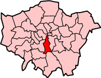
Norbury is a suburban district in south London, administratively part of the London Borough of Croydon. It sits on the boundary with the London Borough of Lambeth and the London Borough of Merton, and shares the SW16 postcode with neighbouring Streatham. The area lies approximately 6.7 miles (10.8 km) south of Charing Cross, making it a commuter-friendly suburb with easy access to central London.
Image gallery
4 Images


Character and built environment
Norbury is primarily residential, with a mix of housing types ranging from older terraces and Victorian buildings to interwar semi-detached homes and smaller modern developments. The commercial heart is concentrated along a high street where independent shops, cafés, restaurants and local services serve the surrounding neighbourhood. Small parades of retail units, community centres and places of worship reflect its diverse, family-oriented population.
History and development
The transformation of Norbury from rural land to suburban district followed the wider expansion of London in the 19th and early 20th centuries. Improved rail and road connections encouraged housing development and the establishment of local amenities, shaping the pattern of streets, parks and local institutions seen today. While the area lacks a single dominant landmark, its history is visible in architectural details and conservation pockets.
Amenities, green space and community life
Residents have access to a range of facilities: primary and secondary schools, libraries, health centres and recreational grounds. Green spaces and small parks provide leisure opportunities and contribute to the suburban character. Local groups organise community events and activities that reflect Norbury's multicultural population.
Transport links
Norbury benefits from a variety of public transport options that connect it to central London and neighbouring districts. Regular bus routes run through the high street and rail services from the local station provide commuter journeys into the city. Road links make nearby borough centres and shopping areas readily accessible.
Notable distinctions
- Administrative position: part of Croydon while bordering Lambeth and Merton (Croydon, Lambeth, Merton).
- Postcode and local identity: shares SW16 with Streatham, creating close ties between the communities.
- Proximity to central London: about 6.7 miles south of Charing Cross, which influences commuting patterns and local property demand.
For further local information, residents and visitors commonly consult borough resources, neighbourhood forums and transport providers to find up-to-date details on services and events.
Related articles
Author
AlegsaOnline.com Norbury: district profile in south London Leandro Alegsa
URL: https://en.alegsaonline.com/art/70659