
Nagqu Prefecture (Nagchu) — Tibet Autonomous Region
Nagqu Prefecture is the largest prefecture-level division in Tibet, known for its high‑altitude Changtang grasslands, very low population density, nomadic pastoralism and fragile alpine ecosystems.
Overview
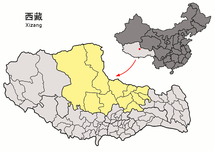
Nagqu (also rendered Naqu or Nagchu) is the largest prefecture-level division in the Tibet Autonomous Region of China, covering roughly 450,000 square kilometres. The prefecture occupies vast high‑plateau landscapes of grassland, lakes and mountain ranges and includes extensive portions of the Changtang plateau. Average elevation is among the highest in the world, and human settlement is sparse compared with most parts of China.
Image gallery
6 Images


Geography and climate
The terrain includes alpine steppe, cold desert, seasonally frozen wetlands and scattered mountains. Permafrost, strong solar radiation, low atmospheric pressure and an arid, cold climate influence local ecology and land use. Numerous salt and freshwater lakes, braided rivers and wetlands provide important habitats for migratory birds and rare plateau species.
Population and society
Population density in Nagqu is very low; official figures from the early 2000s recorded around 363,000 inhabitants (2001), most of them ethnically Tibetan. Traditional livelihoods center on nomadic and semi‑nomadic pastoralism—yak, sheep and goat herding remain central to household economies and culture. Seasonal migration, clan networks and Buddhist institutions continue to shape social life.
Administration and economy
Administratively Nagqu is organised as a prefecture-level division with an administrative centre commonly called Nagqu (Nagchu) town. The local economy is dominated by animal husbandry, supplemented by small‑scale agriculture where conditions allow, animal products (wool, hides, dairy), and limited mineral and salt extraction. Modern infrastructure development has brought new services and markets but also pressures on traditional grazing patterns.
Transport and infrastructure
Roads and railway links connect Nagqu with Lhasa and other regions, improving access for goods, services and tourism. Improved transport has facilitated economic integration while raising concerns about environmental impacts and cultural change in remote communities.
Nature, culture and conservation
Much of Nagqu overlaps with important conservation areas of the Changtang, which protect high‑altitude wildlife such as the Tibetan antelope (chiru), wild yak and kiang (Tibetan wild ass). Local culture reflects Tibetan Buddhist traditions and nomadic lifeways: monasteries, seasonal festivals and equestrian sports are prominent. Balancing development, livestock needs and protection of fragile ecosystems is a continuing policy and local challenge.
Notable points
- Largest prefectural division in the Tibet Autonomous Region by area.
- Extensive high‑altitude grasslands with very low population density.
- Longstanding nomadic pastoralist traditions and significant conservation value.


Administrative outline
| Name | Tibetan | Wylie | Chinese | Pinyin |
| Municipality of Seni (formerly Nagqu) | ནག་ཆུ་རྫོང་ | nag chu rdzong | 色尼区 | Nàqū Xiàn |
| Lhari County | ལྷ་རི་རྫོང་ | lha ri rdzong | 嘉黎县 | Jiālí Xiàn |
| Biru County | འབྲི་རུ་རྫོང་ | 'bri ru rdzong | 比如县 | Bǐrú Xiàn |
| Nyainrong County | གཉན་རོང་རྫོང་ | gnyan rong rdzong | 聂荣县 | Nièróng Xiàn |
| Amdo County | ཨ་མདོ་རྫོང་ | a mdo rdzong | 安多县 | Ānduō Xiàn |
| Xainza County | ཤན་རྩ་རྫོང་ | shan rtsa rdzong | 申扎县 | Shēnzhā Xiàn |
| Circle suction | སོག་རྫོང་ | sog rdzong | 索县 | Suǒ Xiàn |
| Baingoin County | དཔལ་མགོན་རྫོང་ | dpal mgon rdzong | 班戈县 | Bāngē Xiàn |
| Baqên County | སྦྲ་ཆེན་རྫོང་ | sbra chen rdzong | 巴青县 | Bāqīng Xiàn |
| Nyima County | ཉི་མ་རྫོང་ | nyi ma rdzong | 尼玛县 | Nímǎ Xiàn |
| Shuanghu Special District | མཚོ་གཉིས་དོན་གཅོད་ཁྲུའུ་ | mtsho gnyis don gcod khru'u | 双湖特别区 | Shuānghú Tèbié Qū |
Climate
The climate in Nagqu is bitterly cold, especially in winter, with temperatures not rising above freezing even during the day. At night, they can occasionally fall below -35 °C. The lowest temperature ever measured in Nagqu is -41.2 °C.
| Nagqu | ||||||||||||||||||||||||||||||||||||||||||||||||
| Climate diagram | ||||||||||||||||||||||||||||||||||||||||||||||||
| ||||||||||||||||||||||||||||||||||||||||||||||||
| Monthly average temperatures and precipitation for Nagqu
Source : www.meteo365.de | |||||||||||||||||||||||||||||||||||||||||||||||||||||||||||||||||||||||||||||||||||||||||||||||||||||||||||||||||||||||||||||||||||||||||||||||||||||||||||||||||||||||||||||||||
Related articles
Author
AlegsaOnline.com Nagqu Prefecture (Nagchu) — Tibet Autonomous Region Leandro Alegsa
URL: https://en.alegsaonline.com/art/68114
Sources
- xzta.gov.cn : Nagqu