Langemark-Poelkapelle
Langemark-Poelkapelle is a rural municipality in West Flanders, Belgium, notable for World War I battlefields, cemeteries and memorials. Coordinates 50°54′N 02°55′E; population 7,774 (2007).

Overview
Langemark-Poelkapelle is a municipality in West Flanders, in the Flemish region of Belgium. It lies at approximately 50°54′ North, 02°55′ East. The area is predominantly rural, with fields, small villages and a landscape shaped by agriculture and the history of the Ypres Salient. In 2007 the municipality had 7,774 inhabitants.
Image gallery
5 Images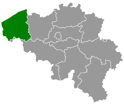


Geography and communities
The municipality covers several villages and hamlets clustered around wide arable fields and local roads. The terrain is low and flat, typical of inland West Flanders, and the built environment includes parish churches, village centres and small farms. Its location north of the city of Ypres places it within a region visited by many who study First World War history.
History and wartime significance
Langemark-Poelkapelle and the surrounding countryside were the scene of intense fighting during World War I. The area figures in accounts of battles that formed part of the Ypres Salient, including actions in 1914 and the later Third Battle of Ypres (Passchendaele) in 1917. Because of this, the landscape contains numerous military cemeteries, memorials and sites of historical interest.
Landmarks and tourism
Administration and economy
Administratively the municipality belongs to the Arrondissement of Ypres and is governed by a municipal council responsible for local services. The economy remains largely agricultural, with supplementary income from tourism linked to heritage and commemorative events. The combination of rural life and historical significance defines the character of Langemark-Poelkapelle today.
Related articles
Author
AlegsaOnline.com Langemark-Poelkapelle Leandro Alegsa
URL: https://en.alegsaonline.com/art/55870
Sources
- statbel.fgov.be : Werkelijke bevolking per gemeente op 1 januari 2007 / Population de droit par commune au 1 janvier 2007 (.xls)
- statbel.fgov.be : Geografische coördinaten van de gemeenten (.xls)