
Abraham Ortelius: Flemish cartographer and compiler of the first modern atlas
Abraham Ortelius (1527–1598), a Flemish cartographer and geographer, produced the Theatrum Orbis Terrarum (1570), a landmark atlas that standardized map presentation and influenced the development of modern cartography.
Overview
Abraham Ortelius (14 April 1527 – 28 June 1598) was a notable Flemish mapmaker and compiler who is widely credited with producing the first modern bound atlas. Trained and active in Antwerp during the 16th century, he combined maps, texts and references in a consistent format that made geographic information more accessible to scholars, navigators and collectors of his time. He is often described as both a cartographer and a geographer because his work blended mapmaking with geographic description and scholarship.
Image gallery
9 Images


The Theatrum Orbis Terrarum and its format
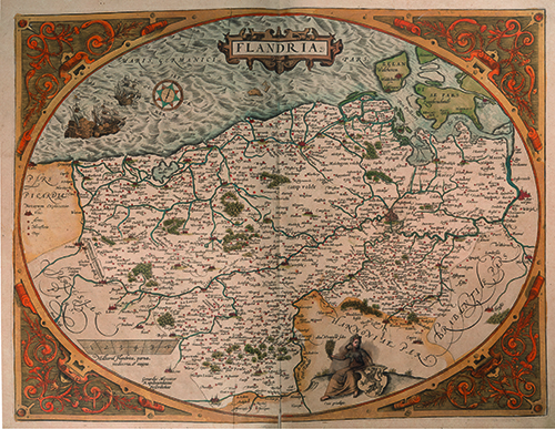
Ortelius’s most famous publication, the Theatrum Orbis Terrarum (Latin for "Theatre of the World's Globe"), first appeared in 1570 in Antwerp and is commonly regarded as the first modern atlas. The volume presented maps on a uniform page size, each accompanied by brief descriptive text, place names and references to sources. By arranging maps in a regular, book-bound sequence he made it possible to consult many regional maps in one portable work, a departure from single-sheet globes and loose maps that had been prevalent before.
Characteristics and production
Rather than engraving every map himself, Ortelius acted primarily as a compiler and editor. He gathered plates and information from a wide network of contemporary cartographers and publishers, harmonized their presentation, and often acknowledged contributors. Key features of his approach included:
- Standardized map size and page layout suitable for binding;
- Consistent decorative elements such as cartouches and title banners, making maps visually coherent;
- Brief accompanying texts that summarized geographic, historical or navigational notes;
- Attribution and cross-references that helped readers trace information back to sources.
Historical context and influence
Ortelius worked during the European Age of Exploration, when voyages of discovery were rapidly expanding knowledge of coasts and continents. By compiling and disseminating up-to-date maps in one volume, the atlas accelerated the spread of geographic knowledge across courts, universities and maritime communities. His publishing practice helped establish standards for later atlases and map series, and encouraged cooperation and information exchange among cartographers across Europe.
Notable observations and legacy
Late in his life Ortelius made a speculative observation about the matching shapes of continental shorelines, suggesting that parts of the world may once have been joined and later separated by natural forces. Although not formulated as a scientific theory in the modern sense, this remark is often cited as an early precursor to later ideas about continental movement. Ortelius’s name endures in the history of cartography for bringing together scholarship, art and practical layout into a single, influential publication. His atlas was reprinted in many editions and translated into other languages, ensuring a broad and lasting impact on map publishing.
Further reading and notable facts
Ortelius maintained extensive correspondence with scholars and mapmakers of his era, and his editorial methods anticipated modern practices of citation and compilation. The Theatrum set a template copied by numerous successors and remains a reference point in the study of early modern cartography. For more detailed bibliographic or biographical sources, consult specialized works on sixteenth-century map publishing and the development of atlases.
Related articles
Author
AlegsaOnline.com Abraham Ortelius: Flemish cartographer and compiler of the first modern atlas Leandro Alegsa
URL: https://en.alegsaonline.com/art/486
Sources
- ui.adsabs.harvard.edu : 1994Natur.367..407R
- doi.org : 10.1038/367407a0