List of settlements in Bangladesh: overview, types, and major towns
Overview of settlements in Bangladesh including administrative structure, types (cities, towns, villages), examples of major cities and towns, historical growth, and distinctions such as city corporations vs municipalities.
Bangladesh is home to a dense and varied network of human settlements that range from large metropolitan centers to small rural villages. These settlements are organized within an administrative framework that shapes governance, services, and development. While the capital city dominates national economic and cultural life, other cities and towns serve as regional hubs for commerce, education, and transport.
Image gallery
10 Images


Administrative structure and settlement types
Settlements in Bangladesh are commonly classified by their administrative status and size. Key categories include:
- City corporations — larger urban centers governed by elected corporations responsible for municipal services.
- Municipalities (pourashavas) — urban towns with municipal councils providing basic local services.
- Towns and market centers — smaller urbanized places that act as service centers for surrounding rural areas.
- Villages — rural settlements forming the primary residential and agricultural units.
Historical development
The pattern of settlements reflects centuries of inland and coastal habitation, colonial-era administration and infrastructure, and rapid post-independence urbanization. Trade routes, river systems and colonial rail and port investments shaped early urban growth. In recent decades, economic change and internal migration have accelerated expansion of city outskirts and transformed many towns into larger urban agglomerations.
Examples of major cities and towns
Prominent urban centers that are widely recognized for their regional importance include:
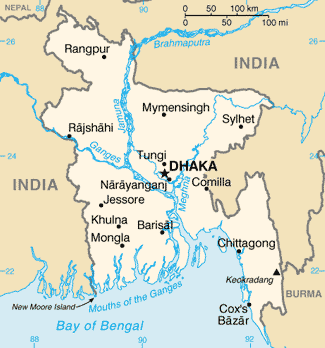
- Dhaka — the national capital and principal economic and administrative center.
- Chattogram (Chittagong) — major port city and industrial hub.
- Khulna, Rajshahi, Sylhet, Barishal (Barisal), Rangpur, and Mymensingh — important regional cities with universities, markets and transport links.
- Numerous district towns and municipal centers that deliver government services and local markets to rural populations.
For a compiled registry and names of settlements across administrative units, consult a comprehensive list or gazetteer, such as the official list and other reference sources.
Understanding the distinctions between metropolitan areas, city proper limits, and surrounding suburban or peri-urban settlements is important for planning, infrastructure investment and statistical reporting. The names of places may also appear with variant spellings in English due to transliteration from Bengali, so single settlements are sometimes seen under different romanized forms.
Overall, Bangladesh's settlements form a complex mosaic shaped by geography, history and ongoing demographic change. Their study is essential for urban planners, development practitioners, and anyone seeking to understand the country's social and economic landscape.
Related articles
Author
AlegsaOnline.com List of settlements in Bangladesh: overview, types, and major towns Leandro Alegsa
URL: https://en.alegsaonline.com/art/125131