Victoria Island (Canadian Arctic)
Large Arctic island split between Nunavut and the Northwest Territories; remote tundra landscape with small Inuit communities, important for Arctic ecology, culture and northern sovereignty.
Overview
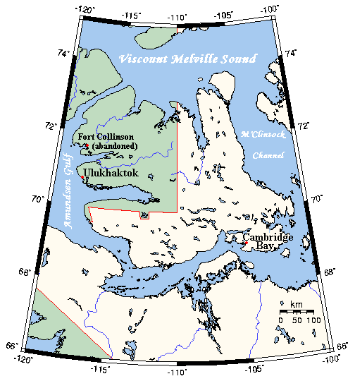
Victoria Island is a major landmass in the far north of Canada, located within the Canadian Arctic Archipelago. It is the country’s second largest island after Baffin Island and ranks among the world’s largest islands. The island’s area is commonly reported as 217,291 square kilometres (83,897 sq mi), making it considerably larger than many temperate islands and nearly comparable in size to parts of northern Europe. Administratively the island is divided: most of it lies in Nunavut while the western third belongs to the Northwest Territories.
Image gallery
5 Images


Geography and environment
The landscape of Victoria Island is characteristically Arctic: low-lying tundra, patchy wetlands and numerous fjords and bays cut into a predominantly rocky coastline. Permafrost is widespread and much of the surface is underlain by continuous or discontinuous permafrost, shaping drainage and vegetation. Summers are short and cool, winters long and extremely cold; sea ice extends over coastal waters for much of the year and opens seasonally along some sheltered channels. The island supports Arctic-adapted wildlife, including migratory seabirds, seals, Arctic foxes and polar bears, and it forms part of ecological corridors that are sensitive to climate change.
People, communities and culture
Human habitation on Victoria Island is sparse and concentrated in a few small settlements. Indigenous peoples have lived in the area for millennia; today the population is predominantly Inuit and Inuvialuit, who maintain a mix of traditional subsistence activities (hunting, fishing and harvesting) and contemporary livelihoods. As recorded in earlier census data, the island’s total population has been small (for example, about 1,875 people were counted in 2006), with the largest settlement being Cambridge Bay. Other communities, such as Ulukhaktok (formerly known as Holman), are smaller but culturally important local centres.
History and exploration
The island’s human history stretches far back before European contact; archaeological evidence shows long-term seasonal use by Indigenous groups. European mapping and naming of the island took place during 19th-century Arctic exploration, and the island was named in honor of Queen Victoria. Over the next century explorers, traders and government expeditions charted much of its coastline and interior, bringing the region into broader cartographic and political awareness.
Economy, transport and modern life
Economic activity on Victoria Island is limited and largely local. Subsistence harvesting remains central to community food security and culture. There is modest wage employment in public services, local stores, tourism services during brief summer seasons, and occasional mineral exploration. Transport is primarily by aircraft between communities and by seasonal marine access; winter ice roads and snowmobile trails provide local links. Small airports, including one serving Cambridge Bay, connect residents to southern hubs for supplies and services.
Notable facts and conservation concerns
- Victoria Island’s administrative split between two territories is an unusual feature that reflects historical boundaries in northern Canada.
- Its size places it well above many better-known islands; comparisons are often drawn with islands such as Newfoundland and the island of Great Britain to give scale.
- The island is strategically and scientifically important: it is part of northern sovereignty discussions, supports ongoing community-led stewardship, and is a location for Arctic environmental and climate research.
For readers seeking more detailed maps, demographic updates or scientific studies, official territorial pages and Arctic research organizations provide current information and resources. Aerial imagery and field studies continue to improve understanding of this remote, ecologically fragile region.
Related articles
Author
AlegsaOnline.com Victoria Island (Canadian Arctic) Leandro Alegsa
URL: https://en.alegsaonline.com/art/104992