Northwest Territories
![]()
This article explains the territory in northern Canada. For the historic area northwest of the Ohio River in the United States, see Northwest Territory.
The Northwest Territories (English Northwest Territories [nɔɹθˌwɛst ˈtʰɛɹɪtʰɔɹiz], French Territoires du Nord-Ouest [tɛʁiˈtwaʁ dy nɔʁˈwɛst]) are an area (territory) in Canada along with Yukon and Nunavut. These three territories, which form the north of the state of Canada, are directly under the jurisdiction of the Canadian federal government, unlike the provinces in the south. The capital of the Northwest Territories is Yellowknife.
In 2016, 41,786 people lived in an area of 1,143,793.86 km². Of these, 20,635 were aboriginal, i.e. Inuit, Métis or First Nations, as the Indians are called in Canada. The latter are divided into 26 tribes with more than 17,000 members. The population, which remained almost unchanged at 41,462 in 2011, lives mainly around the capital and at the mouth of the Mackenzie into the Beaufort Sea.
The climate is polar, especially in the north, and flora and fauna are adapted to the short summers and long winters, with the largest herds of caribou in the Americas, and herds of musk oxen in the north.
The economy is mainly based on the exploitation of raw materials. The fur trade no longer plays a significant role, although it was of considerable importance for the development of the area.
Originally, the Northwest Territories comprised most of Canada and all of its north. The territory of Yukon belonged to the Northwest Territories until 1898, the territories of the provinces of Alberta and Saskatchewan until 1905, parts of Manitoba until 1912. The territory was further reduced in size with the creation of the territory of Nunavut in 1999. The plural still used today for the administrative unit Northwest Territories was rendered factually obsolete by the creation of the two other territorial administrative units.
Geography
Extent and structure
The Northwest Territories border Yukon to the west, Nunavut to the east, British Columbia to the southwest, Alberta to the south and Saskatchewan to the southeast. In the extreme southeast, the territory also abuts the province of Manitoba at the Four Corners quadrangle.
After the Great Lakes, Canada's largest lakes are found here, such as Great Bear Lake with an area of 31,153 km² and Great Slave Lake with 27,048 km². Between the largest lakes by far is Lac la Martre, the third largest lake in the territory with 1776 km².
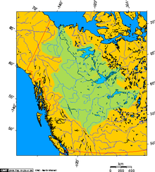
The largest drainage area is that of the Mackenzie in the west, which takes its outlet in Great Slave Lake. To it flow rivers such as the Liard, which in turn receives the South Nahanni River, and the Peel River, but only a small part of which is in the territory, and the Keele River. To the east are numerous lakes, among the largest of which are the foursome of Kasba Lake (1341 km²), MacKay Lake (1061 km²), Aylmer Lake (847 km²), and Clinton-Colden Lake (737 km²). Hottah (918 km²), Selwyn (717 km²) and Wholdaia Lake (678 km²) join further east.
In the north, some islands of the Canadian Arctic Archipelago in the Arctic Ocean belong to the territory, such as Banks Island, Prince Patrick Island and parts of Victoria Island and Melville Island. The two largest lakes there are Aubry Lake and Colville Lake.
The highest point is with 2773 meters a nameless peak, which is unofficially called Mount Nirvana and lies in the Mackenzie Mountains, which are also the highest mountain range. It also forms the border to Yukon. The second highest mountain is Mount Sir James MacBrien, 26 km to the north, at 2762 metres.
Geology and landscape
Liquid basalt was deposited almost 1.3 billion years ago in the area around the Coppermine River over an area of 170,000 km². Within less than five million years, basalt was deposited up to a height of 3.5 km. The Mackenzie Hotspot was an extremely active magma area, and later other volcanic hotspots developed in Nunavut as far as Ellesmere Island.
To the west, the Mackenzie Mountains form part of the Northern Rockies. Along the western border of the territory, ranges such as the Tawu Range and the Backbone Range form sections of the Mackenzie Mountains. On its eastern side are comparatively forested river valleys, as well as in the south of the territory, where the capital Yellowknife is also located at the confluence of the Yellowknife River with the North Arm of Great Slave Lake.
In the Cretaceous period, the low-lying areas east of the Mackenzie Mountains, now part of the Mackenzie drainage basin, were covered by an estuary. To the east of the Mackenzie rise plateaus such as the Horn Plateau (838 m), or ranges such as the Franklin Mountains (Cap Mountain, 1577 m), mountainous landscapes interspersed with numerous lakes still further east. Eastward of the two large lakes of the territory, a largely pathless lake landscape follows, through which, northeast of the Great Bear Lake, the border to Nunavut is already drawn.
In the extreme north, the coast of the mainland extends from the mouth of the Mackenzie to the Amundsen Gulf, a region that is arctic and has little vegetation, and where only the village of Paulatuk exists. In addition, several islands belong to the territory, such as part of Victoria Island, on the west coast of which is the settlement of Ulukhaktok, Banks Island, which rises to 750 m, or Prince Patrick Island. The Arctic landscape is geologically very young. The area was completely covered by glaciers 20,000 years ago and only from about 8000 BC it became increasingly ice-free from south to north.
To the southwest of Fort Smith lies the most significant gypsum karst area in North America, with numerous caves, sinkholes (the most famous being Pine Lake) and underground rivers. Wood Buffalo National Park contains salt-crusted areas whose salt comes from the estuary here, which once covered most of the territory.
Climate
In the south of the territory the climate is subpolar, in the north - arctic. In the so-called cryosphere there is long-lasting frost up to permafrost. Accordingly, summers are somewhat milder in the south, shorter and cooler in the north. In winter, temperatures below -40 °C are not uncommon. For example, temperatures in Yellowknife were consistently below -37 °C between December 31, 1993 and January 19, 1994. Despite a very cold winter in 2007/08, when Yellowknife experienced -40 °C for nine days, winters over the past 25 years have been characterized by comparatively high temperatures. The lowest temperature ever recorded of -57.2 °C was recorded in Fort Smith on December 26, 1917. Precipitation has been low, but there was widespread rainfall with heavy hail around the capital on July 20, 2008, with temperatures exceeding 30 °C (86 °F). In the subarctic (Yellowknife), the average maximum temperature is -23 °C in January and 21 °C in July, and -33 °C and 10 °C respectively in the arctic zone. There are 20 to 24 hours of daylight in June and up to 24 hours of darkness in December.
flora and fauna
While the west and the south of the territory are covered by forests that become thinner towards the north, the east and the north are beyond the forest line. Black spruce is frequently represented, beyond the forest line ground-hugging plants dominate, such as counter-leaved saxifrage (purple mountain saxifrage), the northernmost growing higher plant species.
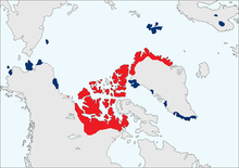
Seven large herds of caribou exist in the territory, numbering up to over half a million animals, of which the Qamanirjuaq herd, living in the east, is the largest. Without them settlement by the earliest inhabitants would have been almost impossible. The Thompsen River valley on Banks Island, on the other hand, forms one of the most important habitats for muskoxen, which have been protected in Canada since 1917. However, local Inuit are allowed to kill a small number of animals each year. Their numbers are estimated at 50,000, and there are also around 26,000 moose, at least 10,000 wolverines and 15,000 wolves living in the territory.
Cities and towns
See also: List of municipalities in the Northwest Territories
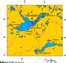
By far the largest chamber of settlement is formed by Great Slave Lake, with the upper Mackenzie. There is Yellowknife, the capital of the Territory, and the largest town, with a population of 19,569. It is on Great Slave Lake, similar to the second largest town, Hay River, with a population of 3,528. A little further south is Fort Smith, already almost in Alberta. Also in the Great Slave Lake area is Behchokò, with a population of 1,874 (including residents of the reserve), formerly Rae-Edzo and the largest Dené settlement, and Fort Simpson and Fort Providence on the Mackenzie. Outside this large chamber of settlements another is found in the mouth of the Mackenzie, where Inuvik, the third largest town, is located, as are Fort McPherson and Tsiigehtchic, formerly Arctic Red River, with a population of 172.
The following table lists the ten largest municipalities in the Territory (including all places that have the municipal status of City, Town or Village), their region and municipal status, and their population figures from the respective censuses by Statistics Canada, the national statistics agency.
| Community | Region | Community status | Population | ||||||
| 01991 | 01996 | 02001 | 02006 | 02011 | 02016 | ||||
| Deline | Sahtu | Charter community | 536 | 526 | 472 | 533 | |||
| Fort McPherson | Inuvik | Hamlet | 759 | 878 | 761 | 779 | 792 | 700 | |
| Fort Providence | South Slave | Hamlet | 645 | 748 | 753 | 727 | 734 | 695 | |
| Fort Simpson | Dehcho | Village | 1.142 | 1.257 | 1.163 | 1.216 | 1.238 | 1.202 | |
| Fort Smith | South Slave | Town | 2.480 | 2.441 | 2.185 | 2.364 | 2.496 | 2.542 | |
| Hay River | South Slave | Town | 3.253 | 3.611 | 3.510 | 3.648 | 3.606 | 3.528 | |
| Inuvik | Inuvik | Town | 3.206 | 3.296 | 2.894 | 3.484 | 3.463 | 3.243 | |
| Norman Wells | Sahtu | Town | 627 | 798 | 666 | 761 | 727 | 778 | |
| Tuktoyaktuk | Inuvik | Hamlet | 918 | 943 | 930 | 870 | 854 | 898 | |
| Yellowknife | North Slave | City | 15.179 | 17.275 | 16.541 | 18.700 | 19.234 | 19.569 | |

Settlement Chamber Great Slave Lake

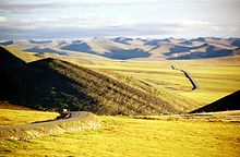
Richardson Mountains, view from Wright Pass to the Dempster Highway

Distribution area of muskoxen, red: distribution area in the early 19th century, blue: distribution in the 20th century

Mackenzie drainage area
Population
| Population development | |
| Year | Inhabitants |
| 1871 | 48.000 |
| 1891 | 98.967 |
| 1911 | 6.507 |
| 1931 | 9.316 |
| 1951 | 16.004 |
| 1961 | 22.998 |
| 1971 | 34.805 |
| 1981 | 45.740 |
| 1991 | 57.649 |
| 2001 | 37.560 |
| 2006 | 41.464 |
| 2011 | 41.462 |
| 2016 | 41.786 |
The early population figures are unreliable on the one hand, and on the other hand they refer to the considerably larger area of the Northwest Territories of the 19th century. Thus, only the 1911 census, i.e. after the secession of Yukon, Alberta and Saskatchewan, provided more accurate and comparable results. Similarly, the 1991 census and the secession of Nunavut.
The First Nations and Inuit and Métis who originally lived here form the absolute majority of the population, but about one-fifth of the population call themselves Canadians, and about half have European, mainly English, Scottish and Irish, but also French and German ancestors.
Native American groups make up four First Nations of the Gwich'in in the Mackenzie area. The Teetl'it Zheh or Fort McPherson live on the Peel River and are the largest Gwich'in group in the Northwest Territories. Their name means "people of the headwaters." The second group is the Tsiigehtchic ("People of the Plains"), who live in the village of the same name. The Edhiitat Gwich'in ("Delta People") live in Aklavik on the Peel Channel in the MacKenzie Delta, as do the Nihtat Gwich'in ("Mixed Nations") who live in Inuvik on the East Channel.
The second major group is made up of speakers of the Chipewyan languages, primarily the Fort Resolution/Deninu Kue First Nation and Smiths Landing. Between 2006 and 2011, there was again stagnation in population growth, but population growth in the other northern and inhospitable provinces of Nunavut and Yukon was very high, 11.6 and 8.3 percent respectively in just 5 years. The reason is not known and the Canadian Census Bureau is expecting a noticeable growth again between 2011 and 2016.
According to the 2006 Census, the following ten ethnic groups were the most represented in the Northwest Territories (multiple responses were possible):
- First Nations - 36.0
- "Canadian" - 19.6 %
- English - 16.6
- Scots - 14.0
- Irish - 12.0
- Inuit - 11.2
- French - 10.4
- Germans - 8.1 %
- Métis - 8.0
- Ukrainians - 3.4
Twenty-six First Nations are recognized in the territory, with a combined membership of about 17,000 people as of February 2009. The largest group with about 2,700 members are the Tli Cho between Great Bear and Slave Lake, formerly called Dog Rib. Other recognized tribes with their registered dependents, according to the Department of Indian Affairs and Northern Development, are:
|
|
Questions and Answers
Q: How many people currently live in the Northwest Territories?
A: As of 2018, 44,541 people live in the Northwest Territories.
Q: What is the capital of the Northwest Territories?
A: The capital of the Northwest Territories is Yellowknife.
Q: What are some geographical features of the Northwest Territories?
A: The Northwest Territories has many geographical features, including the Great Bear Lake, the Mackenzie River and Nahanni River, which is a national park and a UNESCO World Heritage Site.
Q: When did the Northwest Territories enter the Canadian Confederation?
A: The Northwest Territories entered the Canadian Confederation in 1870.
Q: How did the Dominion of Canada come to possess the Northwest Territories?
A: The Hudson's Bay Company gave the land to the Dominion of Canada.
Q: How many representatives does the Northwest Territories have in the Canadian government?
A: The Northwest Territories have one person in the House of Commons and the Canadian Senate.
Q: What happened to the eastern part of the Northwest Territories in 1999?
A: In 1999, the eastern part of the Northwest Territories became the territory of Nunavut.
Search within the encyclopedia