
Regions of Slovakia (Kraje): overview, structure and list
Outline of Slovakia's eight administrative regions (kraje), their districts, capitals, area and 2001 population figures; history and role in national administration.
Overview
Slovakia (country) is divided into eight higher-level administrative units called kraje (singular: kraj), commonly translated as regions. These regions form the primary subnational tier for statistical purposes and regional administration. Each region is named after its administrative centre (capital) and is further subdivided into smaller districts (okresy) and municipalities.
Image gallery
1 Image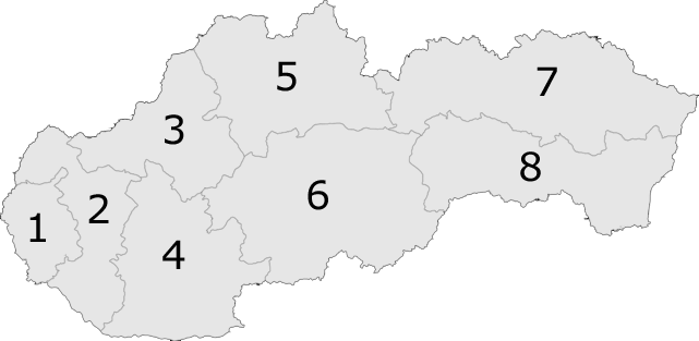
Administrative structure
The regional level groups local government tasks that exceed the capacity of individual municipalities while remaining below central government authority. Below the regions are 79 districts (okresy), which in turn contain numerous towns and villages. Capitals of the larger cities, such as Bratislava and Košice, have additional layers of local organisation and attract a concentration of services and institutions.
List of regions
- Bratislava Region — capital Bratislava. 8 districts; population (2001): 599,015; area: 2,053 km². The region contains the national capital and is geographically the smallest but one of the most densely populated.
- Trnava Region — capital Trnava. 7 districts; population (2001): 550,103; area: 4,108 km².
- Trenčín Region — capital Trenčín. 9 districts; population (2001): 605,582; area: 4,501 km².
- Nitra Region — capital Nitra. 7 districts; population (2001): 713,442; area: 6,343 km².
- Žilina Region — capital Žilina. 11 districts; population (2001): 692,232; area: 6,788 km².
- Banská Bystrica Region — capital Banská Bystrica. 13 districts; population (2001): 662,121; area: 9,455 km². It is among the largest regions by area and includes extensive mountain landscapes.
- Prešov Region — capital Prešov. 13 districts; population (2001): 789,968; area: 8,993 km².
- Košice Region — capital Košice. 11 districts; population (2001): 766,012; area: 6,753 km².
History and development
The system of kraje in Slovakia has changed over time. A regional tier existed in the mid-20th century; there were interruptions and reforms around the end of the Cold War era that altered the exact administrative map. The modern configuration of eight regions is the established scheme for administration and for many statistical classifications used by national authorities and by the European Union.
Importance and distinctions
Regions are important for planning, development funding, transport infrastructure, education and healthcare coordination. They differ markedly in size, population and economic focus: Bratislava Region is the political and economic centre around the capital city, while eastern regions such as Prešov and Košice cover larger rural and mountainous areas. Regional boundaries often reflect historical, geographic and economic patterns, and many local identities remain strongly linked to historic counties and cultural regions.
For more detailed information on any particular region, administrative maps, current population figures and the roles of regional government bodies, consult official national sources and statistical offices linked to each region's administration.
Related articles
Author
AlegsaOnline.com Regions of Slovakia (Kraje): overview, structure and list Leandro Alegsa
URL: https://en.alegsaonline.com/art/81899