
Jhangi (Jhangi Syedan) — Union Council in Abbottabad District
Jhangi, locally called Jhangi Syedan, is a Union Council north of Abbottabad city in Khyber Pakhtunkhwa, Pakistan. It includes northwestern suburbs and surrounding villages; elevation about 1,201 m.
Overview
Jhangi, often referred to by residents as Jhangi Syedan, is one of the administrative Union Councils within Abbottabad District. It lies in the northern part of the district and forms part of the greater urban and rural fringe north of Abbottabad city. In Pakistan's administrative hierarchy Jhangi is a local government unit that combines urban neighborhoods with outlying villages and small agricultural areas. The name used locally suggests historical ties to families known as Syeds, but the area today contains a mix of residential and village settlements.
Image gallery
1 Image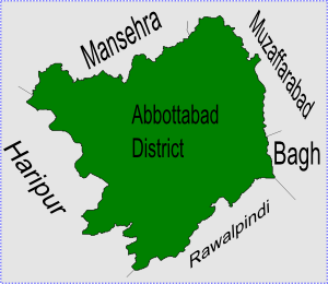
Geography and climate
Jhangi sits at approximately 34°12'0"N 73°13'60"E and rises to about 1,201 metres (3,943 feet) above sea level. Its terrain is typical of the lower slopes and valleys that surround the Abbottabad basin, with undulating hills, cultivated terraces and built-up residential pockets. The climate mirrors that of the nearby city: comparatively mild summers, cool winters and higher rainfall than the plains farther south. Vegetation ranges from cultivated fields and orchards in valley spots to scattered woodland on the higher slopes.
Administration and subdivisions
As a Union Council, Jhangi is a basic local government unit responsible for municipal-style services, local planning and representation. Union Councils in Pakistan commonly include several neighborhoods and adjacent villages; Jhangi covers northwestern suburbs of Abbottabad alongside smaller settlements outside the city boundary. Local offices coordinate with district authorities for education, health and infrastructure projects.
History and local identity
The area around Abbottabad developed under successive regional administrations; Jhangi's identity emerged as the city expanded and nearby villages became more connected to urban life. The informal name Jhangi Syedan points to historical settlement by families identifying as Sayyids in the locality, a naming pattern found in other South Asian communities. Over time the Council has blended rural and urban characteristics as residents commute, farm and engage in trade.
Economy, services and transport
Economic activity in Jhangi combines small-scale agriculture, local retail and services that serve suburban neighborhoods. Many residents depend on jobs and services in Abbottabad city, and transport links are oriented toward the district capital. Public and private road connections provide access for daily commuting, goods movement and schooling. Local institutions typically include primary schools, small clinics and marketplaces that serve nearby communities.
Notable facts and context
- Jhangi is part of the provincial framework of Khyber Pakhtunkhwa in Pakistan, and its affairs are overseen at district level by Abbottabad authorities.
- Its position immediately north-west of Abbottabad places it within the city's suburban expansion while retaining rural pockets and village life.
- Exact demographic statistics for the Union Council vary with census updates; local planning relies on district figures and field surveys.
For further administrative and geographic context, consult district-level resources and local government publications that describe Union Council responsibilities, boundaries and development programs.
Related articles
Author
AlegsaOnline.com Jhangi (Jhangi Syedan) — Union Council in Abbottabad District Leandro Alegsa
URL: https://en.alegsaonline.com/art/50147
Sources
- abbottabad.gov.pk : Jhangi Union Council
- abbottabad.sdnpk.org : Administrative Units of District Abbottabad
- fallingrain.com : Location of Jhangi