Iğdır — city in eastern Turkey
Iğdır is a provincial capital in eastern Turkey, near the borders with Armenia, the Nakhchivan exclave of Azerbaijan and Iran. Known for a relatively mild plain, agriculture, and views of Mount Ararat.
Overview
Iğdır is the administrative center of Iğdır Province in the Eastern Anatolia Region of Turkey. The city lies on a low-lying plain at the eastern edge of Anatolia and had a population estimated around 76,950 in 2009. Its position close to several international frontiers gives it a distinctive regional role.
Image gallery
10 Images


Geography and landscape
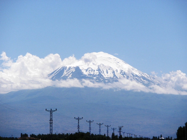
Iğdır occupies a relatively flat valley that contrasts with the surrounding high plateaus and mountains. From parts of the city and plain there are clear views of Mount Ararat (Ağrı Dağı) to the south. The local terrain and lower elevation produce a milder microclimate than much of Eastern Anatolia.
Climate and agriculture
The climate is continental but warmer and drier than neighboring uplands, with hot summers and cold winters. This combination permits intensive cultivation on irrigated land. Farmers grow cereals, orchards and other crops suited to a longer growing season than is typical for the region.
History and population
The area around Iğdır has a long, layered history with influences from ancient Armenian polities, Persian and Anatolian realms, and later Ottoman and Russian administrations during the 19th and early 20th centuries. Today the city reflects a mix of cultural and linguistic traditions, including Turkish, Azerbaijani (Azeri) and Kurdish elements.
Economy, transport and importance
Iğdır's economy is driven by agriculture, local services and cross-border commerce. Its border location affects transport routes and trade flows in the easternmost part of the country. The city serves as a regional service center for surrounding rural districts.
Notable facts
- Mount Ararat views: The mountain is a prominent landmark visible from the plain.
- Milder plain: Iğdır's valley climate makes it agriculturally productive compared with nearby highlands.
- Border region: Proximity to Armenia, the Nakhchivan exclave and Iran shapes its strategic and commercial role.
Related articles
Author
AlegsaOnline.com Iğdır — city in eastern Turkey Leandro Alegsa
URL: https://en.alegsaonline.com/art/46591