Chainat Province (Chai Nat) — Central Thailand
Chainat (Chai Nat) is a central Thai province on the Chao Phraya plains known for agriculture, riverine landscapes, and birdlife. Its capital is Chai Nat and the province blends rural economy with natural attractions.
Overview
Chainat province, often spelled Chai Nat and written in Thai as ชัยนาท, lies in the heart of central Thailand. The provincial capital shares the same name. Chainat occupies low-lying plains shaped by the Chao Phraya River system and is primarily rural in character. Agriculture and fisheries remain central to local livelihoods, while river control and irrigation projects influence land use and seasonal flooding.
Image gallery
8 Images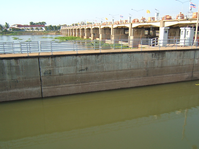


Geography and environment
The landscape of Chainat is dominated by flat alluvial plains and wetlands fed by tributaries of the Chao Phraya. These conditions support wet-rice cultivation, fish ponds and a mosaic of small water bodies that attract waterfowl. Seasonal floods replenish soils and sustain traditional farming cycles. Vegetation is largely agricultural with patches of riverside forest and scrub along canals and dikes.
History and development
Chainat has historical roots as a frontier and military settlement protecting approaches to older Thai capitals. Over centuries it evolved from a strategic riverside post into an administrative province in the modern Thai state. The province’s development has followed broader central plains trends: expanding irrigation, road links to larger cities, and gradual diversification from subsistence farming to market-oriented agriculture.
Economy and society
The local economy centers on rice cultivation, orchard and vegetable growing, freshwater aquaculture and small-scale industry that supports agricultural processing. Market towns serve surrounding villages and seasonal festivals connect communities with regional trade. Education, health and administrative services are concentrated in the provincial capital.
Administration and attractions
Like other Thai provinces, Chainat is organized into districts, subdistricts and villages under national administrative structures. Points of interest include riverside temples, community markets and wetlands popular with birdwatchers. The province is noted for facilities and parks that highlight waterfowl and migratory birds, making it a regional stop for nature tourism.
Distinctive facts
- Name: The Thai name reflects historical concepts of victory and defense.
- Water management: River control and irrigation projects are central to local agriculture and flood mitigation.
- Rural character: Chainat illustrates the central plains’ combination of intensive agriculture and seasonal wetland habitats.
Visitors and students of Thai regional geography will find Chainat representative of the central lowlands: shaped by river dynamics, rooted in farming traditions, and gradually integrating conservation and tourism alongside agricultural change.
Related articles
Author
AlegsaOnline.com Chainat Province (Chai Nat) — Central Thailand Leandro Alegsa
URL: https://en.alegsaonline.com/art/18342
Sources
- tourismthailand.org : "Chainat"
- tourismthailand.org : "Chainat Bird Park"