
Rivers of Luxembourg: principal waterways and their significance
Overview and brief guide to Luxembourg's main rivers, their locations, roles in history and economy, cross-border character, and notable tributaries and features.
Luxembourg's landscape is defined by a network of small to medium rivers that shape valleys, provide water resources and mark sections of international borders. Although the country is compact, its waterways include internationally known rivers such as the Moselle as well as numerous regional streams that have influenced settlement, industry and transport over centuries.
Image gallery
1 Image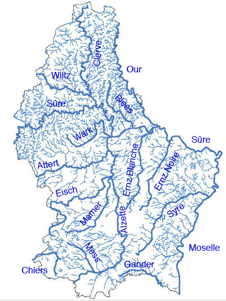
Major rivers
- Moselle (Mosel) – Forms a long portion of Luxembourg's eastern boundary with Germany and is the centre of the Moselle wine-growing region.
- Sûre (Sauer) – One of the largest tributaries feeding toward the Moselle; its upper basin in Luxembourg includes the Upper Sûre reservoir, an important water supply and recreation area.
- Alzette – Flows through Luxembourg City and several towns; its valley has been a focus for urban development and historical industry.
- Pétrusse – A small but historically prominent stream that joins the Alzette in Luxembourg City and has shaped the city's deep valley and fortifications.
- Our – Runs along parts of the northeastern border with Germany and is characteristic of the Ardennes landscape.
- Ernz Blanche and Ernz Noire – Two Ardennes rivers known locally as the White and Black Ernz; they drain hilly, forested country in the north.
- Attert, Wiltz and others – A number of additional rivers and tributaries cross regions of western and northern Luxembourg, creating local valleys and ecosystems.
Historically these rivers powered mills, supported small industries and determined the locations of towns and roads. The Moselle valley is noted for viticulture; smaller streams provided water for agriculture and for ironworking in earlier centuries. Many river valleys also became transport corridors and later routes for rail and road links.
Several Luxembourg rivers cross national borders or serve as frontier streams, reflecting the country's central position in western Europe. The multilingual environment means many waterways are known by different names in French, German and Luxembourgish, for example Moselle/Mosel and Sûre/Sauer.
Today the rivers are valued for tourism, wildlife and recreation as well as for utility functions. Protected areas and regional parks, such as those associated with the Upper Sûre reservoir, aim to balance water supply, nature conservation and leisure use. Local conservation efforts focus on water quality, habitat restoration and sustainable management of river corridors.
For an official listing and maps of Luxembourg's rivers, see the national inventory and resources: official list.
Related articles
Author
AlegsaOnline.com Rivers of Luxembourg: principal waterways and their significance Leandro Alegsa
URL: https://en.alegsaonline.com/art/125039