Rivers of Maine: Major Waterways and Regional Guide
Overview and regional listing of Maine's rivers, their major basins, ecological and historical roles, common uses, and conservation issues.
Maine's rivers are a defining feature of its landscape, connecting inland lakes and forests to the Atlantic Ocean, the Bay of Fundy and neighboring provinces. They vary from short coastal streams to long, forested systems that cross state and international boundaries. Together these waterways create important habitats, support fisheries and recreation, and have shaped settlement and industry in the state.
Image gallery
6 Images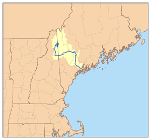


Characteristics and drainage
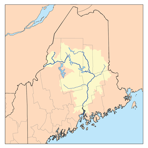
Most rivers in Maine flow east or south toward the Gulf of Maine, though several large basins reach the Bay of Fundy or the Saint John River system to the northeast. Rivers arise from mountain runoffs, glacial lakes and wetland complexes and commonly form estuaries and tidal marshes near their mouths. The Penobscot, Kennebec, Androscoggin and Saco are among the best-known systems, and the Penobscot River is notable for having the largest drainage area contained mostly within the state.
Major rivers by region
Below is a regional selection of rivers that illustrates Maine's geographic diversity. This is not exhaustive but highlights principal waterways and tributaries.
- Northern and Upper Maine: St. John River (forms part of the international border), Allagash River, Aroostook River, Fish River.
- Penobscot basin and central Maine: Penobscot River, Piscataquis River, Mattawamkeag River, Penobscot Bay tributaries.
- Western and interior: Kennebec River, Dead River, Sandy River, Sebasticook River.
- Androscoggin & Saco region: Androscoggin River, Little Androscoggin River, Saco River, Ossipee headwaters (border area).
- Midcoast and southern coast: Sheepscot River, Damariscotta River, Presumpscot River, Piscataqua River (border with New Hampshire).
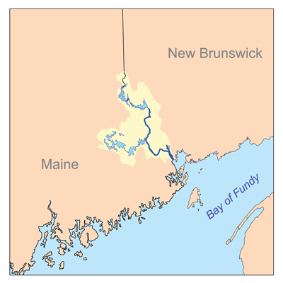
- Down East and eastern border: St. Croix River (east border with New Brunswick), Machias River, Narraguagus River.
History, uses and cultural importance
Rivers in Maine have long supported Indigenous communities, commercial fisheries and coastal settlements. During the 19th and early 20th centuries many rivers powered sawmills and paper mills, and some waterways were altered by dams to support industry and hydropower. Today they remain vital for commercial and recreational fishing, boating, paddling and tourism; the remote Allagash Wilderness Waterway, for example, is popular for multi-day canoe trips.
Conservation and notable facts
Conservation efforts focus on improving water quality, restoring migratory fish runs and removing or modifying dams to reestablish passage for species such as Atlantic salmon and river herring. Estuaries like Merrymeeting Bay, where rivers meet coastal waters, provide crucial habitat for birds and juvenile fish. Rivers also face pressures from development, invasive species and changing precipitation patterns, making watershed-scale planning increasingly important.
For a compiled inventory, see the List of rivers and for contextual information about the state see Maine.
Related articles
Author
AlegsaOnline.com Rivers of Maine: Major Waterways and Regional Guide Leandro Alegsa
URL: https://en.alegsaonline.com/art/125041