Rivers of Antarctica: overview, types, and notable streams
Overview of Antarctic rivers — mostly seasonal meltwater streams and subglacial channels — their characteristics, scientific importance, and notable examples such as the Onyx River.
Overview
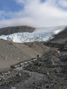
When people speak of rivers in Antarctica they normally mean two quite different phenomena: seasonal surface meltwater streams that flow during the brief summer, and hidden subglacial channels that carry water beneath the ice sheet. Surface rivers are concentrated where bare ground or thin ice occurs, especially in the McMurdo Dry Valleys and along parts of the Antarctic Peninsula. For a focused compilation see the comprehensive list and regional context at Antarctica.
Image gallery
4 Images

Characteristics
Antarctic rivers are ephemeral and highly variable. Surface flows depend on solar radiation and local snow or glacier melt; many streams run only for a few weeks or months. Water temperatures are near freezing and channels commonly transport suspended rock flour and organic mats of microbes. Subglacial channels are sustained by basal melting and pressure-driven flow and are typically inferred from radar, seismic surveys, and satellite observations rather than seen directly.
History and discovery
Early explorers recorded occasional summer streams in coastal oases, but systematic study accelerated with twentieth-century Antarctic science stations and the detailed surveys of the McMurdo Dry Valleys. Modern remote sensing and fieldwork revealed a wider diversity of meltwater features and helped map important sites such as oases, temporary proglacial rivers, and subglacial drainage pathways beneath the ice sheet.
Scientific importance and uses
Antarctic rivers are natural laboratories. Surface streams host microbial communities adapted to extreme cold and low nutrients and offer insights into life’s limits. Sediment and isotopic records in river-fed lakes help reconstruct past climates. Subglacial channels influence how ice moves and how meltwater reaches the ocean, so they are important to studies of glacial dynamics and sea-level change.
Notable rivers and streams
- Onyx River — the best-known continental surface river, flowing seasonally in the McMurdo Dry Valleys toward Lake Vanda.
- Alph River — a small named meltwater channel, notable mainly for its naming and occurrence in the Ross Island/Wright Valley region.
- Numerous short meltwater streams on the Antarctic Peninsula and in the Dry Valleys that drain glaciers into lakes, fjords, or the sea.
- Subglacial drainage channels and inferred rivers beneath the Antarctic Ice Sheet that transport basal meltwater toward grounding lines and the ocean.
Because most Antarctic flows are seasonal or hidden under ice, any list of rivers emphasizes named examples and broad categories rather than a large roster of perennial, navigable waterways. For further reading and catalogues of named features consult the regional compilations and the linked resources above.
Related articles
Author
AlegsaOnline.com Rivers of Antarctica: overview, types, and notable streams Leandro Alegsa
URL: https://en.alegsaonline.com/art/124964