Vakaga — remote prefecture in the northeastern Central African Republic
Vakaga is a remote, sparsely populated prefecture of the Central African Republic with its capital at Birao. It features semi-arid savanna, limited infrastructure, cross-border trade and recurring humanitarian challenges.
Vakaga is one of the country's sixteen prefectures, located in the far northeast of the Central African Republic. Its administrative centre and largest town is Birao, which functions as the political and commercial hub for a vast and lightly inhabited territory. Vakaga is known for its remoteness, long distances between settlements and a landscape that contrasts sharply with the more forested regions of the country.
Image gallery
3 Images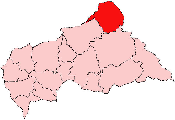

Geography and environment
The prefecture is dominated by open savanna and scattered dry woodlands, reflecting a transition between Sahelian and Sudanian climates. Rainfall is seasonal, and the terrain includes flat plains with occasional rocky outcrops. These environmental conditions shape livelihoods and limit intensive agriculture; water and pasture availability vary greatly between wet and dry seasons.
Population, society and settlement
Vakaga is one of the most sparsely settled parts of the nation. Settlements cluster around Birao and a few other towns and villages, while many communities are small and dispersed. The population is ethnically and linguistically mixed, with local languages and customary structures important in daily life. Access to education, healthcare and formal services is limited outside urban centres.
Economy and infrastructure
The local economy depends largely on pastoralism, small-scale agriculture and cross-border trade. Birao serves as a market and logistical node for goods moving between neighbouring regions and countries. Transport infrastructure is rudimentary: roads are often unpaved and difficult to use in the rainy season, and many places rely on seasonal tracks or airstrips for access.
History, administration and contemporary issues
Historically administered from the colonial period through independence, Vakaga has remained peripheral to national political and economic centres. In recent decades the prefecture has experienced instability that has affected security, governance and humanitarian needs. International and local relief agencies sometimes operate in the area to support displaced people, basic services and recovery efforts.
- Capital: Birao (administrative and market centre).
- Landscape: semi-arid savanna and dry woodlands.
- Economy: pastoralism, subsistence farming, cross-border trade.
- Challenges: limited infrastructure, seasonal access, recurring humanitarian concerns.
Vakaga's combination of strategic frontier position, sparse settlement and environmental constraints gives it a distinct role within the country's geography. Understanding its local dynamics is important for regional planning, humanitarian response and efforts to improve connectivity and livelihoods in this remote part of the Central African Republic.
Related articles
Author
AlegsaOnline.com Vakaga — remote prefecture in the northeastern Central African Republic Leandro Alegsa
URL: https://en.alegsaonline.com/art/103894
Sources
- stat-centrafrique.com : "Population Prefecture"
- statoids.com : "Central African Republic Prefectures"
- tools.wmflabs.org : 10°20′N 22°45′E / 10.333°N 22.750°E / 10.333; 22.750