Begijnendijk, Flemish Brabant (Belgium)
Begijnendijk is a small municipality in the Flemish Brabant province of Belgium, comprising the villages of Begijnendijk and Betekom. Coordinates: 51°01′N, 04°46′E. Population was 9,468 in 2007.
Overview
Image gallery
3 Images

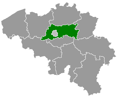
Geography and administration
The town lies in central Belgium at coordinates 51°01′ North, 04°46′ East and occupies a primarily rural-to-suburban landscape. It is part of the provincial network of communities in Flemish Brabant; further context about the province can be found at the provincial site. The municipality is connected to nearby population centers by local roads and public transport links typical of the region.
History and name
The name Begijnendijk likely reflects historical ties to the Low Countries' beguine movement and to dike-building or a raised road ("dijk"). Beguines were lay religious women who lived in semi-independent communities from the Middle Ages onward; many place names in the region preserve that heritage. The settlement developed over centuries as an agricultural and craft community before evolving into a commuter-friendly municipality.
Demographics and economy
In 2007 the population was recorded as 9,468. Since the late 20th century many small Belgian municipalities have experienced gradual growth as people moved from larger cities to suburban or semi-rural towns; Begijnendijk shares that pattern, with a mixed local economy of small businesses, light industry and agriculture, alongside residents who commute to larger employment centers.
Culture, amenities and points of interest

Quick facts
- Country: Belgium
- Region: Flemish Region (Flanders)
- Province: Flemish Brabant
- Coordinates: 51°01′N, 04°46′E
- Population (2007): 9,468
Related articles
Author
AlegsaOnline.com Begijnendijk, Flemish Brabant (Belgium) Leandro Alegsa
URL: https://en.alegsaonline.com/art/10119
Sources
- statbel.fgov.be : Werkelijke bevolking per gemeente op 1 januari 2007 / Population de droit par commune au 1 janvier 2007 (.xls)
- statbel.fgov.be : Geografische coördinaten van de gemeenten (.xls)