Tibetan Plateau (Qinghai–Tibetan Plateau)
Vast high plateau in Central Asia — the world's largest and highest plateau — shaping Asian climate, feeding major rivers, hosting unique ecosystems and high‑altitude cultures, and vulnerable to climate change.
The Tibetan Plateau, often called the Qinghai–Tibetan Plateau, is the highest and one of the most extensive elevated regions on Earth. Lying at the heart of Central Asia, it includes most of the Tibet Autonomous Region and parts of neighboring provinces and territories such as Qinghai Province in China and extends toward areas like Ladakh and Kashmir on the Indian subcontinent. Portions of the plateau fall within the territory of India and are of major geographic and geopolitical importance.
Image gallery
10 Images


Physical characteristics
The plateau covers an area on the order of several million square kilometers and rises to average elevations exceeding 4,500 metres above sea level. Its broad, elevated terrain includes mountain ranges, basins, plateaus and lakes. To the south and southeast it is bounded by the great rise of the Himalayas, which together with the plateau form a dramatic north‑south contrast in elevation and climate. Because of its size and height the region is sometimes described informally as the "roof of the world."
Geology and origin
The Tibetan Plateau formed primarily through the long‑term collision and convergence of the Eurasian landmass with the Indian Plate. This continental collision uplifted crustal rocks and thickened the crust, producing high topography and complex structures of folded mountains and high basins. Uplift and deformation continue today on geological timescales, contributing to seismic activity and ongoing landscape change.
Hydrology and climate influence
Often termed the "water tower of Asia," the plateau is the headwaters region for many major Asian rivers. From its margins flow rivers that supply water to downstream plains and millions of people. Its elevation and heat‑trapping effects strongly influence regional and continental atmospheric circulation, and the plateau plays a central role in shaping Asian monsoon patterns and seasonal weather variability. Scientists study the plateau closely because changes there can alter precipitation regimes far beyond its boundaries.
Ecosystems, people, and culture
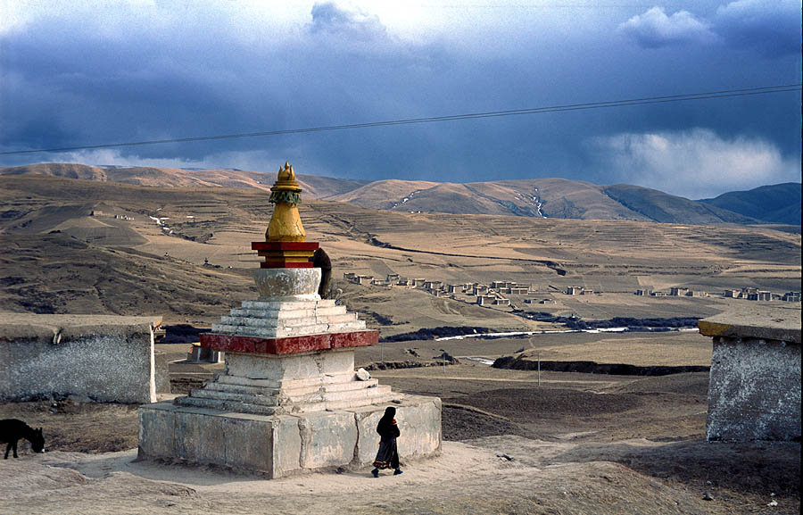
Despite harsh conditions—thin air, low temperatures and high ultraviolet exposure—the plateau supports a mosaic of ecosystems including alpine meadows, cold deserts and wetlands. Vegetation and wildlife have adapted to high‑altitude conditions; pastoralism and small‑scale agriculture persist where soils and water allow. Indigenous Tibetan cultures and other ethnic groups have lived there for millennia, developing distinct languages, religions and practices adapted to the plateau environment. Modern infrastructure such as railways and roads now links some plateau cities to lowland markets, while remoteness remains a defining feature of many areas.
Importance and contemporary concerns
- Key environmental role: glacial and snow reserves on the plateau store freshwater and help regulate river flows.
- Climate sensitivity: warming has led to glacial retreat, permafrost thaw and altered water cycles, raising concerns for downstream water security.
- Human impacts: grazing, infrastructure, resource development and changing land use affect fragile ecosystems and traditional livelihoods.
- Scientific interest: the plateau is a focus for research on high‑altitude biology, paleoclimate records, and atmospheric science.
Notable distinctions
The Tibetan Plateau is often called the "Third Pole" because it contains the largest volume of ice outside the polar regions and plays a role analogous to polar ice in the Earth's climate system. Its combination of extreme elevation, central location in Eurasia and ecological and cultural richness makes it a region of global scientific, environmental and strategic significance.
For further introductory maps and overviews see resources on regional geography and climate studies: plateau overview, climate interactions and research on monsoon dynamics. Additional regional and historical information is available through regional studies and governmental summaries at Ladakh and India-focused portals, and provincial resources such as Qinghai Province summaries.


Geography
The highlands are divided into the western Changthang in the Tibet Autonomous Region (AGT) of the People's Republic of China, as well as the central Yarmothang highlands largely located in the Chinese province of Qinghai, the island-like Qaidam basin in Qinghai to the northeast, and the mountainous lands in the transition to the border of Sichuan province. It encompasses most of historic Tibet as well as what is now the Chinese Autonomous Region of Tibet (AGT).
In the north, the hilly to medium mountainous plateau is bordered by the mountain ranges of the Altun-Qilian-Kunlun. In the west the Karakorum Mountains and in the south the Transhimalaya - or depending on the author the Himalaya - form the borders. In the east, the Tanggula Shan and the Bayan Har Mountains are understood as parts of the highlands, while the mountain ranges of the (extended) Hengduan Shan form the eastern border.
Climate
Although the entire highlands of Tibet lie in the subtropical climate zone, the distinct high altitude climate results in extrazonal vegetation that is more reminiscent of cold temperate to polar climates. In contrast, however, there are some crucial differences to be noted:
The climate is characterized by high temperature differences between day and night and by rapid, strong weather changes. The average temperature in Changtang varies, being higher in the south and west than in the north and east. At Lake Aru Co in Rutog County, the average temperature is -8 degrees Celsius, while in Shuanghu in the northeast it is -24 degrees Celsius. The annual temperature fluctuations are not as extreme as the daily ones. For example, temperatures in the west can easily drop from +20 to -40 degrees Celsius. In the northeast, in Shuanghu County, temperatures do not climb above freezing even in July. The average temperature is then about -10 degrees Celsius.
The location in subtropical latitudes and high sea level leads to extremely strong solar radiation, so that the temperatures in summer are about 25 Kelvin higher than they would be without these factors (see mass elevation effect). Equally extreme is the nocturnal radiation, which can bring frosty nights even in summer. The northern half of the highlands is completely permafrost area, in the southern half this only applies to the mountains.
The shielding by the peripheral mountains results in a very dry climate, so that it rarely rains or a snow cover develops. Indirectly, this can be seen in the lack of white winter coat in the animal kingdom (as is known, for example, from the rock ptarmigan and the snow hare of other cold climates). Most precipitation occurs in summer: usually heavy thundershowers during the day and prolonged drizzle and sleet at night with westerly winds. The enormous day/night differences lead to frequent thunderstorms (annual average: 90 days), often associated with squalls and, in some regions, sandstorms. Towards the west and north, the annual mean precipitation drops to 20 to 80 mm.
Related articles
Author
AlegsaOnline.com Tibetan Plateau (Qinghai–Tibetan Plateau) Leandro Alegsa
URL: https://en.alegsaonline.com/art/99774