Thuringia (Thüringen) — central German state
Thuringia (German: Thüringen) is a central German state with a mix of forested highlands, historic cultural centers such as Weimar and Erfurt, about 2.1 million residents, and a varied industrial and cultural economy.
Overview
Thuringia, known in German as Thüringen, is one of the 16 federal states of Germany. Located in the geographic heart of the country, it combines densely forested highlands, broad river valleys and a number of medium-sized cities with historic significance. The state's administrative capital is Erfurt, which functions as its political, cultural and transport hub.
Image gallery
10 Images


Geography and population
Thuringia covers an area of 16,251 km² (6,274.5 sq mi). By area it is one of Germany's smaller states and is commonly described as the sixth smallest state by area. With roughly about 2.1 million inhabitants, it ranks among the less populous German states, retaining a mix of urban centers and large rural tracts. Major landscape features include the Thuringian Forest (Thüringer Wald), the Thuringian Basin and the series of low mountain ranges and plateaus that shape local climate and land use.
Historical development
The region that is now Thuringia has a long and layered history. In the medieval and early modern periods it was divided into many small duchies, principalities and ecclesiastical territories. Cultural consolidation around cities such as Weimar and Eisenach produced important artistic and intellectual movements: Weimar is associated with Goethe and Schiller, while the Wartburg in Eisenach is known for its links to Martin Luther. The modern state of Thuringia first emerged as a political entity in the early 20th century and was reconstituted with Germany's reunification late in the 20th century, inheriting both industrial towns and historic landscapes.
Economy, culture and landmarks
Thuringia's economy blends traditional manufacturing, precision optics and engineering (notably around Jena), with services, research and tourism. The region has a strong academic presence through several universities and research institutes. Cultural tourism is driven by sites connected to classical literature, music and the Reformation, while the Thuringian Forest attracts outdoor recreation year-round. Culinary traditions such as the Thuringian sausage (Thüringer Rostbratwurst) are widely known across Germany.
Administrative structure and notable cities
The state is divided into districts and independent cities; besides Erfurt, other important centers include Weimar, Jena, Gera and Eisenach. Transport links connect Thuringia with neighbouring states, and its central location makes it a crossroads between northern, eastern and southern Germany. Local government responsibilities cover education, policing, cultural affairs and regional planning within the federal framework.
Distinctive facts and modern role
- As a central state, Thuringia has played a notable role in German cultural history and intellectual life.
- Its varied terrain supports both industrial towns and protected natural areas favored by hikers and winter sports enthusiasts.
- Thuringia's mix of small cities and countryside preserves many regional traditions while hosting modern research and manufacturing clusters.
For further reading about the state name, geography and statistics, see entries and resources linked here: local name, nation context, area details 16,251 km² and 6,274.5 sq mi, size ranking area rank, population estimate demographics, and the capital Erfurt.


Geography
Thuringia is located in the middle of Germany and borders on the states of Hesse (length of border 270 km), Bavaria (381 km), Saxony (265 km), Saxony-Anhalt (296 km) and Lower Saxony (112 km). The Free State of Thuringia, like Saxony and parts of Saxony-Anhalt, belongs to the region of Central Germany. As a result of a satellite-based national survey in 2007/2008, the center of Thuringia was determined on the territory of the municipality of Rockhausen in the Ilm district at the coordinates 50° 54′ 12″ N, 11° 1′ 35″ E50.9033333311.0263888889 about eight kilometers south of the Erfurt Cathedral.
The landscape in Thuringia is very diverse. In the far north is the Harz Mountains. To the southeast is an area known as the Goldene Aue, with the fertile valley of the river Helme. In the northwest is the Eichsfeld, a partly forested hilly landscape. In the middle of the country lies the flat, very fertile Thuringian Basin. This region is one of the oldest cultural landscapes in Germany. The first settlements have been documented here since the year 704. The Thuringian Basin is surrounded by various small mountain ranges, such as the Dün in the northwest, the Hainleite and the Windleite directly north of it, as well as the Kyffhäuser in the north, Schmücke, Hohe Schrecke and Finne in the northeast, the Ettersberg in the southeast, the Fahner Höhe in the south and the Hainich in the west. The Hainich National Park is the only national park in the state.
South of the Thuringian Basin is the hilly foothills of the Thuringian Forest, finally the Thuringian Forest itself, as the largest mountain range in the country. To the east, the forest merges seamlessly into the Thuringian Slate Mountains, which in turn merge southeast in the Sonneberg district and in the Saale-Orla district into the Franconian Forest, only the smallest parts of which, however, lie in Thuringia. Together they form the Thuringian-Franconian low mountain range. This low mountain range is crossed by the Rennsteig, the ridge trail. It represents the watershed between the Elbe in the north and the Weser or Rhine in the south. The Thuringian Forest is a ridge mountain range, while the Slate Mountains and the Franconian Forest are plateaus cut by narrow valleys. East of the forest and basin runs the Saale valley. Beyond the Saale lies the Thuringian Woodland to the north, the Vogtland to the south, and the Osterland to the east. In contrast to the former, the Osterland around Altenburg is sparsely forested and very fertile. In the southern administrative district Sonneberg north of the district town Sonneberg the Franconian line runs; this separates in Thuringia the Franconian forest from the Upper Main hill country. Southwest of the Thuringian Forest, in southern Thuringia, lies the Werratal, followed by the Rhön in the west and the Grabfeld in the far south.
The most important rivers in the state are the Werra in the southwest and the Saale in the east. Larger tributaries of the Saale are the Unstrut (with Gera), the Ilm and the Weiße Elster. In the northwest of the country rises the Leine. Altogether the country is divided between the catchment areas of the Weser in the west, the Elbe in the middle and in the east and the Rhine in the extreme south with intersection at the Dreistromstein near Neuhaus am Rennweg. There are no larger natural standing waters in Thuringia, but the Bleiloch and Hohenwarte dams are two of the largest reservoirs in Germany.
The highest elevation in the state is the Große Beerberg in the Thuringian Forest at 983 meters. Other high mountains are the Schneekopf (978 m), the Große Finsterberg (944 m) and the Große Inselsberg (916 m). The highest point of Thuringia measures 1060 meters above sea level and is located on the Bleßberg in the district of Sonneberg (location of the radio station 865 m + 195 m height of the transmitter). Highest mountain in the slate mountains is the Große Farmdenkopf (869 m), in the Thuringian Rhön the Schnitzersberg (816 m) belonging to the Ellenbogen and in the Thuringian Harz the Große Ehrenberg (636 m). Important elevations between the Harz Mountains and the Thuringian Forest are the Birkenberg (533 m) in Eichsfeld, the Alte Berg (494 m) in Hainich, the Kulpenberg (474 m) in Kyffhäuser and the Ettersberg (482 m) near Weimar. South of the Thuringian Forest the Dolmar (740 m) and the Große Gleichberg (679 m) stand out, east of the Saale the highest mountain is the Rosenbühl (653 m) in the southern Vogtland, but without any special relief energy. Furthermore, the central Thuringian Forest and the adjacent western Slate Mountains as well as the Rhön are populated up to the crests, so that about 20 villages in the state are located above 700 meters above sea level, including Oberhof, Neuhaus am Rennweg and Steinheid as the highest villages at an altitude of over 800 metres (in the centre of the village) as well as the Rhön villages of Frankenheim and Birx at 750 metres, which - unlike the proto-industrial early modern foundations in the Thuringian Forest - even date back to the high medieval settlement with an agricultural livelihood. Lowest points are the Unstrut valley between Wiehe and Roßleben (114 m), the Saale valley near Großheringen (120 m), the Werra valley near Lindewerra (145 m) and the Pleisse valley near Treben (150 m).
Climate
Thuringia is located in the temperate climate zone of Central Europe with prevailing westerly winds. As there are already some protective low mountain ranges between the western seas and the Free State, Thuringia's climate is more continental than in the west and north of Germany. This is mainly reflected by colder winters and drier summers than in other parts of the Federal Republic.
Within Thuringia there are very large climatic differences. The Thuringian Basin in the centre of the state is particularly favoured. It is surrounded by mountains, so that the lowest amounts of precipitation in Germany fall there. The record is held by Straußfurt with 242 millimeters of annual precipitation in 1911. 400 to 500 millimeters of annual precipitation with an annual mean temperature of 8.5 degrees Celsius (1961-1990 at the Artern weather station) are normal in the Thuringian Basin. The hilly areas in the state are about average for Germany in terms of climate. In Gera, for example, 624 millimeters of precipitation fall at a temperature of 7.8 degrees Celsius. The mountain zones in Thuringia have an unfavorable climate. On the Schmücke, for example, an average of 1289 millimeters of annual precipitation are measured at a temperature of 4.4 degrees Celsius. Here, the January temperature is -4 degrees Celsius and the July temperature is 12.8 degrees Celsius. In Artern on the northern edge of the Thuringian Basin, the values for these months are -0.7 degrees Celsius and 17.6 degrees Celsius.
Regular natural disasters in Thuringia are in particular floods and storms. Floods usually occur during Vb weather conditions, in which large low-pressure areas with moist Mediterranean air move northwards over the Adriatic Sea, Austria, the Czech Republic and Poland and, by rotating in an anticlockwise direction, cause heavy rain accumulation on the Thuringian Forest and the Slate Mountains. In contrast, the danger of flooding due to rapid snowmelt is less severe, as the elevations of the Thuringian Forest drain into many different rivers. After reunification, flood protection was significantly improved through the designation of appropriate areas and the construction of numerous retention basins, even on small rivers. Storms are particularly problematic for the mountain regions, as the spruce monocultures there, damaged by 20th century pollution, are susceptible to wind breakage, as was recently demonstrated by hurricane Kyrill. Increasing biodiversity in forestry operations should reduce the impact of future storms here. If, as predicted, climate change leads to a more irregular distribution of precipitation, the lowlands in the Thuringian Basin will be exposed to a higher risk of summer drought, as precipitation levels here are quite low. Agriculture is trying to react to this by switching to more drought-resistant varieties.
Geology
The geological situation in Thuringia is characterized by a great variety of geological formations. Almost all layers of the Phanerozoic, i.e. of the last 500 million years, can be traced on the surface or in the areas close to the ground in the various regions of the state.
In relation to the history of its development, Thuringia is divided into four so-called structural levels, which are dominant in the respective regions according to their age:
- the hercynically oriented basement in the Thuringian Slate Mountains
- the transitional or molasse soil belonging to the Saxothuringian in the Thuringian Forest
- the Tafeldeckgebirgsstockwerk in the Thuringian Basin and the Southwest Thuringian Triassic Area
- the loose rock stock in the Weißelster basin
While the geomorphological shape of Thuringia in the south and west is almost exclusively determined by tectonic processes and erosion by precipitation, these structures in the north and east were overformed by the Elster cold period about 400,000 - 320,000 years ago. Accordingly, from a geomorphological point of view, the country is divided into five externally definable areas:
- the Thuringian Mountains, consisting of the Thuringian Forest and the Thuringian Slate Mountains
- the Zechstein and Triassic landscapes of the Thuringian Basin and southern Thuringia
- the southern Thuringian vulcanite areas (Heldburger Gangschar)
- the Kyffhäuser and the Thuringian part of the Harz Mountains
- the Altenburg-Meuselwitz area, which is characterised by open-cast lignite mining and the remains of uranium mining which took place in the second half of the 20th century.
Within the Zechstein and Triassic landscapes, in addition to flat areas, numerous faults characterize the landscape, of which the Eichenberg-Gotha-Saalfeld fault zone, which separates the Thuringian Forest foothills from the Thuringian Basin, is the longest and most conspicuous. In the Zechstein area in the area of the Werra and Wipper rivers there are larger salt deposits, which were mined especially in the 20th century. In the red sandstone area of the Saale valley near Jena, numerous geological phenomena can be observed.
Starting from the extraction of mineral resources such as iron ore, copper slate or gold, which began in the late Middle Ages, especially in the area of the Thuringian Mountains, a theoretical processing of practical geoscientific knowledge developed in the region as early as the 16th century. In 1796 the Societät für die gesamte Mineralogie zu Jena (Society for the entire mineralogy in Jena) was founded, the first geoscientific association ever. It was founded at the suggestion of Goethe, who was its president from 1803 to 1830.
Due to ongoing tectonic processes, smaller earthquakes occasionally occur in the southeast of Thuringia. These have been observed by the University of Jena since the beginning of the 20th century. Today, the Moxa Geodynamic Observatory of the Friedrich Schiller University of Jena is located in the east of the Thuringian Slate Mountains, as is the Center for Engineering Analysis of Earthquake Damage of the Bauhaus University Weimar for the investigation and evaluation of possible consequences of earthquakes not only in this area.
Nature and landscape
Thanks to the diverse geological subsoil and the influence of the low mountain ranges on the local climate, a variety of plant species with different ecological requirements can grow in Thuringia. Thuringia is divided into seven types of natural areas: low mountain ranges, mottled sandstone hill country, shell limestone hill country, basalt hill country, arable hill country, alluvial plains and lowlands, and zechstein belts on mountain edges. Within these natural area types, 38 individual natural areas are distinguished; the Thuringian Mountains natural area is also divided into eight sub-units.
The potential natural vegetation of Thuringia consists of forests that could be divided into different types depending on site conditions. The most widespread would be beech forests dominated by the copper beech (Fagus sylvatica), especially woodrush, woodruff, wood barley and orchid beech forests. Only where site conditions are less ideal could other tree species dominate. Thus, in the dry-warm continental areas of the central Thuringian Basin, sessile oak (Quercus petraea), English oak (Quercus robur), hornbeam (Carpinus betulus) and littleleaf linden (Tilia cordata) would be more common. In the low mountain ranges, on the other hand, the sycamore maple (Acer pseudoplatanus), the Norway spruce (Picea abies) and the now rare silver fir (Abies alba) would be found alongside the copper beech. Only at the highest altitudes of the Thuringian Forest and the Thuringian Slate Mountains would spruce-beech forests be found.
The current flora and fauna are adapted to the German cultural landscape. Due to human use, the vegetation consists mainly of forests, grassland, fields, settlements and water bodies. About one third of the state's area is covered by forest. Thuringia is therefore one of the most densely forested of the federal states. However, only 30 % of this is natural deciduous forest. Coniferous forests, which were established at the end of the 19th and beginning of the 20th century, are the main characteristic. However, the state forestry administration is endeavouring to increase the proportion of deciduous wood again. After hurricane Kyrill caused massive damage in January 2007, especially in the Thuringian forest, some reforestation efforts returned to the native mixed beech-oak forest instead of spruce monocultures. The main tree species in Thuringia are spruce with 42.6 %, copper beech with 20.1 % and Scots pine with 15.7 %. However, the forests are not homogeneously composed mixed forests. According to the locations, the low mountain ranges of the Middle and Eastern Thuringian Forest, the Thuringian Slate Mountains and the Harz Mountains are predominantly covered with spruce. Pine forests are widespread in the red sandstone countries, for example in the Holzland. In the Muschelkalk areas, including the Hainich, Dün and Hainleite, but also in the northwestern Thuringian Forest, beech forests dominate.
The grassland is mainly characterised by dry and semi-dry grasslands, species-rich fresh meadows in the hilly areas have declined considerably. A large proportion of fresh and moist meadows is used as cattle pasture.
The forests of Thuringia are home to roe deer, deer, wild boar, mouflons and foxes, among others. The wildcat (Felis silvestris) has once again found its habitat in the Hainich National Park and in the valley of the White Elster, between Greiz and Wünschendorf. The lynx (Lynx lynx) again roams through the Harz Mountains in the north of the state. The state's nature reserves are home to rare bird species, including the black grouse (Lyrurus tetrix or Tetrao tetrix), the black stork (Ciconia nigra) and the corncrake (Crex crex). For some years there have also been repeated wolf sightings in Thuringia. On the military training area in Ohrdruf a female wolf has been proven to have her territory and mated with a dog. Wolves have also been detected in the Thuringian Forest and in the Holzland. Domestic animal species that are adapted to life in the country include the Thuringian Forest goat, which has been bred for centuries, and the Rhön sheep.
Due to the industrial pollution emitted between 1850 and 1990, parts of Thuringia were severely damaged at the end of this period. Since then, this damage has been partially mitigated. For example, as part of the 2007 Federal Garden Show in Gera and Ronneburg, the former open pit uranium mine in Ronneburg was cleaned up and sealed; the New Landscape Ronneburg was created. Another contaminated site is the tar lake in Rositz near Altenburg, which poses an enormous threat to the environment. Overall, however, the pollution of the air and the waters has decreased considerably; only the Werra - due to the Hessian potash mining - is still so salinated below Dorndorf (the salt content corresponds to that of the Baltic Sea in many places) that many plants and animals cannot survive. Waste water discharges by the K+S company have repeatedly caused disputes in this region between the communities and the states of Thuringia and Hesse. Smaller streams in areas of intensive agricultural use continue to suffer from increased nitrate inputs due to land fertilization.
The Hainich National Park, the Rhön and Vessertal-Thuringian Forest biosphere reserves and the Eichsfeld-Hainich-Werratal, Kyffhäuser, Thuringian Slate Mountains/Upper Saale and Thuringian Forest nature parks are important nature conservation areas in Thuringia. Central areas of the Hainich National Park have been among Germany's 36 World Heritage Sites since their recognition by the World Heritage Committee on 25 June 2011. By 2030, 5% of all forest areas are to be completely taken out of economic use in order to develop into near-natural forests in the long term. In addition to the Hainich, areas in the Hohe Schrecke, in the Hainleite at the Possen and in the Pöllwitz Forest, which were largely used for military purposes before 1990 and are still partly contaminated by ammunition residues, are earmarked for this purpose.


Politics
The state structure of Thuringia is based on the 1993 Constitution of the Free State of Thuringia. According to the Constitution, Thuringia is a Land of the Federal Republic of Germany. It is a democratic, social state governed by the rule of law and committed to the protection of the natural foundations of human life (Article 44). Article 45 states that all State power emanates from the people and that the people carry out their will through elections, referendums and plebiscites.
Legislative
→ Main article: Thuringia state parliament
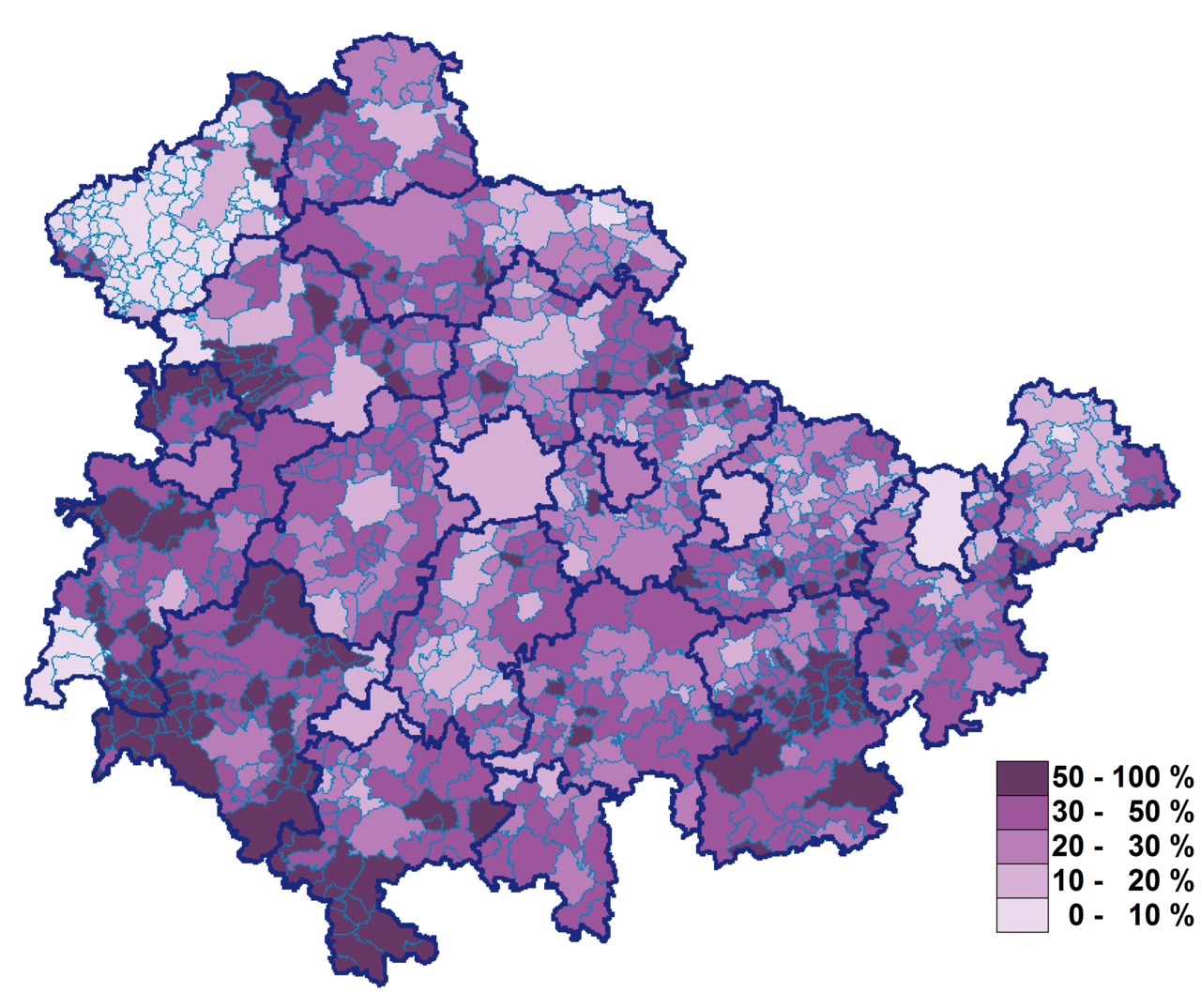
The legislature is the Thuringian state parliament, which is re-elected every five years according to the personalized proportional representation system. The seventh legislature of the Thuringian state parliament consists of 90 deputies and was formed based on the results of the state election of 27 October 2019. The strongest party is Die Linke with 29 seats, followed by the AfD with 22 as well as the CDU with 21 seats. The SPD is one of the smaller parties with 8 seats, as are the Greens and FDP with 5 seats each.
There is the possibility of active participation in the legislature of the people through referendum.
| Results of the state elections in the Free State of Thuringia (in percent) | |||||||
| Year | Voter turnout | CDU | PDS/Left1 | SPD | FDP | Green | |
| 1990 | 71,7 | 45,4 | 09,7 | 22,8 | - – | 9,3 | 6,5 |
| 1994 | 74,8 | 42,6 | 16,6 | 29,6 | - – | 3,2 | 4,5 |
| 1999 | 59,9 | 51,0 | 21,3 | 18,5 | - – | 1,1 | 1,9 |
| 2004 | 53,8 | 43,0 | 26,1 | 14,5 | - – | 3,6 | 4,5 |
| 2009 | 56,2 | 31,2 | 27,4 | 18,5 | - – | 7,6 | 6,2 |
| 2014 | 52,7 | 33,5 | 28,2 | 12,4 | 10,6 | 2,5 | 5,7 |
| 2019 | 64,9 | 21,8 | 31,0 | 8,4 | 23,4 | 5,0 | 5,2 |
1 The PDS existed until 2007; its successor party is Die Linke.
See also: Election results and state governments in Thuringia
Executive
→ Main article: Thuringian state government
The executive branch is led by the Thuringian state government, which consists of the Thuringian Minister President and the ministers. The Minister President is elected by the Landtag by a majority of its members without debate in a secret ballot for the entire legislative period. The Minister President appoints and dismisses the ministers. He also appoints a minister as his deputy. Parliament can only dismiss the Prime Minister by a constructive vote of no confidence.
| Prime Minister of the Free State of Thuringia | |||||||||
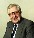
| No. | Image | Name (life data) | Party | Beginning of the term of office | Term end | Duration of the term of office | Cabinets | Thuringian state parliaments | |
| 1 |
| Joseph Duchač (* 1938) | November 8, 1990 | 5 February 1992 | 1 year, 2 months, 28 days (454 days) | I | 1. | ||
| 2 |
| (* 1932) | February 5, 1992 | June 5, 2003 | 11 years, 4 months (4138 days) | I, II, III | 1., 2., 3. | ||
| 3 |
| Dieter Althaus (* 1958) | June 5, 2003 | 30 October 2009 | 6 years, 4 months, 25 days (2339 days) | I, II | 3., 4. | ||
| 4 |
| Christine Lieberknecht (* 1958) | October 30, 2009 | 5 December 2014 | 5 years, 1 month, 5 days (1862 days) | I | 5. | ||
| 5 |
| Bodo Ramelow (* 1956) | December 5, 2014 | February 5, 2020 | 5 years, 2 months (1888 days) | I | 6. | ||
| 6 |
| Thomas Kemmerich (* 1965) | February 5, 2020 | 4 March 2020 | 28 days | none | 7. | ||
| (5) |
| Bodo Ramelow (* 1956) | March 4, 2020 | acting | 1 year and 114 days (479 days) | II | 7. | ||


Further executive organs are the Thuringian police, with 6000 officers on duty, as well as the Office for the Protection of the Constitution, which has gained nationwide media attention due to numerous affairs - especially in the area of right-wing extremism and the NSU.
Judiciary
The judiciary is exercised by the Thuringian Constitutional Court and by the other courts of the Land. The Constitutional Court consists of a president and eight other members. The ordinary judiciary is divided into the Thuringian Higher Regional Court in Jena, the regional courts in Erfurt, Gera, Mühlhausen and Meiningen, to which the four public prosecutors' offices are also assigned, and the subordinate district courts. There are prisons for men in Goldlauter, Gräfentonna, Hohenleuben, Untermaßfeld and Arnstadt (juvenile penal system), for women the Chemnitz Prison is responsible.
The Thuringian Higher Administrative Court has its seat in Weimar.
With the Federal Labour Court in Erfurt, there is also a federal court in Thuringia.
Political development
Thuringia is considered a rather conservative state, especially in rural areas, and was dominated by the CDU at the state political level until the change of government in 2014. Afterwards, the first red-red-green coalition was formed at the state level and, with Bodo Ramelow, a politician from the left was elected prime minister for the first time. The party ties are, as in all of East Germany, not so strong, so that in federal elections the CDU received the most votes in 1990, 1994, 2009 (just ahead of the Left Party), 2013 as well as 2017 and the SPD in 1998, 2002 as well as 2005.
The GDR era and the upheavals following reunification still reverberate politically in the country, for example in the perception of part of the population of being "left behind" or of not having a sufficient political voice. This impression is reinforced by manifest problems in many rural areas, ranging from the aging and migration of the population and the thinning out of infrastructures to vacancies and falling real estate prices. The Thuringia Monitor of the Friedrich Schiller University of Jena has been investigating the socio-political climate in the state and attitudes of the population to value issues with annual surveys since 2000. Even before reunification, there was a small, vociferous right-wing extremist scene in the state, which also appeared violently in the NSU terror cell. Since 2013, a strengthening of right-wing populism has been evident in the country, which also manifested itself in the entry of the Alternative for Germany into the state parliament in 2014 and in the federal election result of 22.7% for the AfD in 2017. Its state chairman Björn Höcke is considered the head of the so-called wing, the right-wing current of his party.
See also: Government crisis in Thuringia 2020
Public budgets
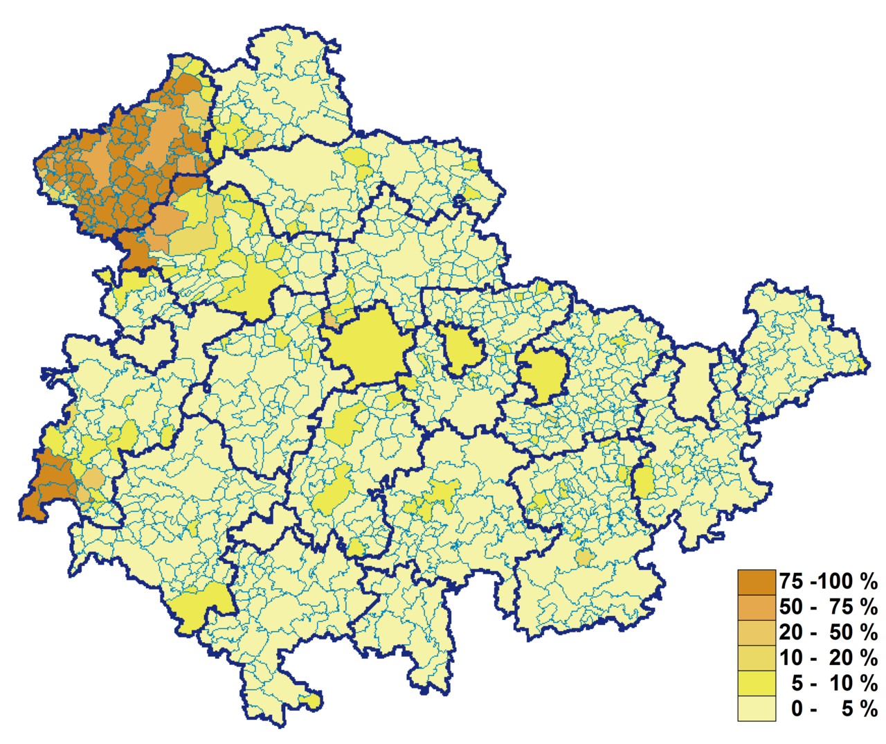
The debt level at the end of 2017 was around 15.8 billion euros or 7372 euros per inhabitant, putting Thuringia in the middle of the pack in a national comparison. Future risks for the state budget result from the expiry of the Solidarity Pact in 2019 and declining payments from EU structural funds due to the comparatively good economic development after 2005. The resulting financing gap has not yet been closed; furthermore, the state will not be able to fully cover its expenses with its own regular revenues in the foreseeable future and will thus remain dependent on financial assistance from outside. Like all the other new Länder, Thuringia has been a recipient of fiscal equalization payments from the Länder since 1990 and receives about EUR 500 million annually.
Many municipalities in Thuringia are over-indebted. While nominal debt levels are not as high as in many western German municipalities, on the other hand tax revenues and thus debt sustainability are also significantly lower. While the two major cities in the state have their debt under control, Gera, Eisenach and the Unstrut-Hainich district (where a state receiver has been appointed), for example, have made headlines since 2010 in view of their poor fiscal situation. In particular, many municipalities and municipal associations in rural areas have hardly any tax revenues, which is why even comparatively low debt levels represent a high burden here, especially in the districts of Nordhausen, Kyffhäuserkreis, Unstrut-Hainich-Kreis and Sömmerda in the north of Thuringia. In the southwest, on the other hand, there are debt-free districts in the Wartburgkreis and Schmalkalden-Meiningen districts, as well as some debt-free municipalities and municipal associations, such as Schleusingen, Floh-Seligenthal and Unterbreizbach.
Military
Due to its central location far from the coast and Germany's western and eastern borders, Thuringia has had only a below-average number of military bases since the 19th century, although at least the state capitals had barracks. The only significant garrison city, however, was Erfurt, which belonged to Prussia and was a fortress city until 1873 and also had a high number of barracks and military personnel in the 20th century.
Weimar developed into an important military location with the rise of the National Socialists. The 1st Panzer Division was established in Weimar (staff building at Jenaer Straße 2, today the Weimar Administrative Court). The military airfield in Nohra also gained in importance. In 1935/36, an airfield with attached barracks was built in the southeast of Nordhausen; the air base essentially served training purposes.
After the Second World War, Thuringia, and in particular Weimar and Meiningen, was a stationing focus for the Red Army with tens of thousands of soldiers. Tank companies, airborne troops and combat helicopter squadrons of the Red Army were stationed in Weimar, and cruise missiles with nuclear warheads were stationed in Rudisleben in the 1970s. The border troops of the GDR stationed the helicopter squadron 16 in Nordhausen and Meiningen (until 1990). Thuringia was located at the interface of two alliances and was systematically developed into a deployment area for the NVA and the Red Army.
After 1990, in the course of the dissolution of the National People's Army and the withdrawal of the Soviet armed forces in Germany, many barracks were closed, so that today there are only eight barracks of the Bundeswehr, which are concentrated with two exceptions in the northern center of the country on the edge of the Thuringian Basin. In detail, these are the Henne Barracks and the Löberfeld Barracks in Erfurt, the Kyffhäuser Barracks in Bad Frankenhausen, the Karl Guenther Barracks in Sondershausen, the Görmar Barracks in Mühlhausen, the Friedenstein Barracks in Gotha, the Pioneer Barracks in Gera and the Werratal Barracks in Bad Salzungen. They provide work for 7000 soldiers and 700 civilian employees. The only military training area in the Free State is the Ohrdruf military training area. With the military training area Weberstedt existed until 1990 a second in the country. After its dissolution, it was integrated into the Hainich National Park.
Since January 2013, the Bundeswehr Logistics Command has been located in Erfurt at division level. The LogKdo is responsible for the command and control of all logistic forces of the armed forces.
National coat of arms and flag
→ Main article: Thuringian coat of arms and flag of Thuringia
The current coat of arms of the Free State of Thuringia was initially regulated in a simple parliamentary act which was adopted by the Landtag on 30 January 1991 and, in accordance with its paragraph 3, entered into force with retroactive effect from 3 October 1990. Later, one sentence of this Act was incorporated verbatim into the Thuringian Constitution. The Act of 30 January also empowered the Land Government to regulate further details in a statutory instrument, and this power was exercised on 11 April 1991. Among other things, it regulates who is entitled to use the state coat of arms, the state seal, the official seal and the official shield.
The coat of arms of Thuringia shows in the lasur blue shield the four times equally wide red-silver striped, golden armed and crowned "coloured lion" of the Ludovingians, surrounded by eight silver stars.
As the oldest coloured representation of the "Thuringian original coat of arms", the coat of arms of Landgrave Konrad of Thuringia from the 13th century has been preserved. The war of succession 1264/65 dismissed Hesse politically independent, which since then has the "colored lion" (reversed striped: silver-red) in the coat of arms. When the state of Thuringia united on 1 May 1920 from the seven republican Thuringian small states, seven silver stars on a revolutionary republican red background were chosen as the state coat of arms in imitation of the federal star banner of the USA. The National Socialists gave Thuringia a more archaic, beaded coat of arms. With the reestablishment of the state of Thuringia in 1991, the current Thuringian coat of arms was derived from the historical basis. The eighth star stands for the additional territorial districts of Erfurt, Mühlhausen, Nordhausen, Schmalkalden and Suhl, which belonged to the Free State of Thuringia and were formerly annexed to Prussia.
Partnerships
Thuringia maintains partnerships with:
- Poland of
 the Polish voivodship Lesser Poland,
 - France
 of the former region of Picardy (now Hauts-de-France) in France,
 - Hungary
 Hungary,
 - China People's Republic of
 the Chinese province of Shaanxi,
as well as friendly relations:
- Russia
 of the Russian Republic of Tatarstan,
 - Ukraine
 of the Ukrainian oblast of Lviv,
 - France Auvergne in France,
- Brazil
 Santa Catarina in Brazil.


Questions and answers
Q: Where is Thuringia located?
A: Thuringia is located in central Germany.
Q: What is the size of Thuringia?
A: Thuringia has an area of 16,251 km2 (6,274.5 sq mi), making it the sixth smallest state in Germany by area.
Q: How many inhabitants does Thuringia have?
A: Thuringia has 2.1 million inhabitants, making it the fifth smallest state in Germany by population.
Q: What is the capital of Thuringia?
A: The capital of Thuringia is Erfurt.
Q: What language is spoken in Thuringia?
A: The main language spoken in Thuringia is German.
Q: What is the main industry in Thuringia?
A: The main industries in Thuringia include manufacturing, mechanical engineering, and tourism.
Q: What famous historical figures are associated with Thuringia?
A: Famous historical figures associated with Thuringia include Martin Luther, Johann Sebastian Bach, and Friedrich Schiller.
Related articles
Author
AlegsaOnline.com Thuringia (Thüringen) — central German state Leandro Alegsa
URL: https://en.alegsaonline.com/art/99719