Beaufort scale
An observational scale that classifies wind force by effects on sea and land; developed for maritime use and still used in forecasts, shipping and weather reporting worldwide.
The Beaufort scale is an observation-based system for describing wind strength by its visible effects rather than by direct instrument readings. Mariners and meteorologists use it to communicate conditions at sea and on land when instruments are unavailable or to provide a qualitative complement to measured values. The scale links a numbered force to characteristic effects on water, objects and vegetation and is often cited in marine forecasts and logbooks; see wind and speeds in operational reports and the role of measurement versus judgement in weather observation, illustrated by observation–based systems.
Image gallery
10 Images


Structure and typical effects
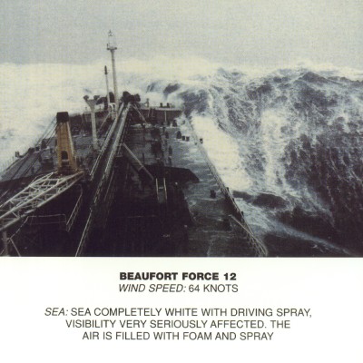
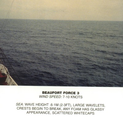
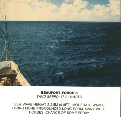
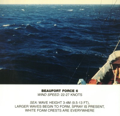
The commonly used Beaufort scale runs from 0 (calm) to 12 (hurricane force). Each step corresponds to a range of wind intensity and a short descriptive phrase. Rather than only numeric bounds, the scale emphasizes practical effects: for example, small ripples at sea and smoke rising vertically for calm conditions, broken tree branches and heavy structural damage at the upper end. Forecasts may translate these descriptions to precise units (knots, km/h or m/s) for technical use.
- 0–3: light air to gentle breeze — smoke direction, small wavelets on water.
- 4–6: moderate to strong breeze — large waves begin, trees sway and small branches move.
- 7–9: near gale to strong gale — high waves, reduced visibility from spray, difficulty walking against wind.
- 10–12: storm to hurricane — very large waves, widespread structural damage at the highest forces.
Origins and historical development
The scale was devised in the early 19th century by Rear-Admiral Francis Beaufort for consistent reporting aboard Royal Navy ships and later adopted more widely. It was intended to help seafarers relate wind conditions to the handling of sailing vessels and to improve the comparability of logs and charts. The scale was used aboard surveying vessels and other ships, including famous ships of exploration such as HMS Beagle, and it became part of routine naval and meteorological practice; the Royal Navy's role is often noted in histories of the instrument, see Royal Navy.
Extensions, regional practice and related scales
Although the familiar international range is 0–12, several mid-20th-century extensions added higher numbers for very severe tropical systems; these extended labels are now uncommon in international practice but remain in use in some regions that experience intense tropical cyclones. For example, meteorological agencies in China and Taiwan have applied extended categories for strong typhoons. Related marine indices separate the character of the sea from the wind: the Douglas Sea Scale and Douglas Wind Scale describe wave conditions and wind independently to give more detail for navigation and design.
Applications, limitations and notable points
The Beaufort scale is valuable where visual assessment is fastest or instruments are absent: it remains common in ship logs, coastal warnings and public weather descriptions. Its wave-height guidance concerns deep-water, open-sea conditions rather than nearshore surf; wave heights quoted with Beaufort force refer to the open ocean, not coastal shoals or breaking surf, so users should note the difference when planning operations at sea or along the coast (waves, open ocean). The scale complements measured wind speeds and modern forecasting while preserving a simple, widely understood vocabulary for describing wind effects on people, structures and vessels.
Questions and answers
Q: What is the Beaufort scale?
A: The Beaufort scale is a scale used to measure wind speeds based on observation rather than accurate measurement.
Q: Who developed the Beaufort scale?
A: The Beaufort scale was developed by Francis Beaufort, an officer of the Royal Navy in 1805.
Q: How many levels are there in the Beaufort scale?
A: There are twelve levels in the Beaufort scale, plus 0 for "no wind".
Q: What were beaufort levels 13 to 17?
A: Beaufort levels 13 to 17 were Hurricane levels used in special cases from 1946 to 1970, but they are no longer used internationally.
Q: Why do China and Taiwan still use beaufort levels 13 to 17?
A: China and Taiwan still use beaufort levels 13 to 17 because they often have typhoons.
Q: What are the wave heights given for in the Beaufort scale?
A: The wave heights given in the Beaufort scale are for waves on the open ocean, not near the shore.
Q: How are the Douglas Sea Scale and Douglas Wind Scale different from the Beaufort scale?
A: The Douglas Sea Scale and Douglas Wind Scale are similar to the Beaufort scale but they separate the sea from the wind.
Related articles
Author
AlegsaOnline.com Beaufort scale Leandro Alegsa
URL: https://en.alegsaonline.com/art/9877