The Fens
![]()
The title of this article is ambiguous. For other meanings, see under FENS.
The Fens (English: The Fens = the marshes) are a fen and marsh landscape in eastern England, spreading around the sea bay of The Wash, which was the flood plain of the rivers Witham, Welland, Nene and Ouse.
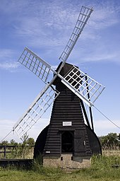
After being drained under the direction of the Dutch engineer Cornelius Vermuyden in the 17th century, the course of the River Ouse changed and the land subsided, causing flooding. Attempts to pump the water out with wind pumps had little success. It was only after the steam-powered pump was invented around 1820 that the flooding was stemmed. Conversion to pasture and farmland was not complete until the mid-19th century. Due to the subsidence of the drained moorland, parts of the Fens today lie up to 4.6 metres below sea level.
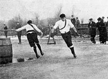
At the turn of the 18th and 19th centuries, the flooded areas often froze over in winter, and bandy, similar to ice hockey, developed here. As early as 1790 bandy games of the Bury Fen Bandy Club are mentioned. There were also early speed skating competitions here by the then popular Fen Skaters, with prizes to be won (see also History of Speed Skating).
An impression of the Fens before draining is given by the Wicken Fen Nature Reserve. In the Cambridge University Botanic Garden, the vegetation of the Fens has been replanted, including the marsh verbena, which is almost extinct in Britain, as well as the caraway-leaved silge and the non-burning nettle Urtica dioica subsp. subinermis.
The Fens are the setting for the novel "Waterland" by Graham Swift.

Fen skater at the turning point

Wicken Fen: wind-powered water pump
See also
- Fens (Geography)
- Sietland
Questions and Answers
Q: What is the Fenland?
A: The Fenland is a naturally marshy region in eastern England that was mostly drained several centuries ago. It is now mostly a flat, damp, low-lying agricultural region.
Q: Where is the Fenland located?
A: The Fenland is mostly around the coast of the Wash and includes parts of four counties - Lincolnshire, Cambridgeshire, Norfolk and a small area of Suffolk.
Q: How big is the Fenland?
A: The whole of the Fenland occupies an area of nearly 1,500 sq mi (3,900 km2).
Q: What type of water can be found in a fen?
A: A fen consists of neutral or alkaline water with relatively large quantities of dissolved minerals but few other plant nutrients.
Q: How has modern drainage impacted the Fens?
A: Modern drainage has radically transformed the Fens so that today arable farming has almost entirely replaced pastoral and its economy heavily invested in producing crops such as grains and vegetables.
Q: What are some significant settlements within the Fens?
A: Some significant settlements within the Fens include Cambridge, Boston, Spalding, Wisbech and King's Lynn.
Q: What is Holme Fen in Cambridgeshire known for?
A:Holme Fen in Cambridgeshire is known for being home to lowest land point in the United Kingdom at around 2.75 metres below sea level.
Search within the encyclopedia