Tenochtitlan
![]()
The title of this article is ambiguous. For other meanings, see Tenochtitlan (disambiguation).
Tenochtitlan (Nahuatl![]() , IPA: [te.noːʧ.'ti.tɬan] with long o and emphasis on the i, Spanish Tenochtitlán) was the capital of the Aztec Empire from the 14th to the early 16th century, until it was conquered and destroyed by the Spanish conquistadors.
, IPA: [te.noːʧ.'ti.tɬan] with long o and emphasis on the i, Spanish Tenochtitlán) was the capital of the Aztec Empire from the 14th to the early 16th century, until it was conquered and destroyed by the Spanish conquistadors.
Probably at the beginning of the 16th century, when the first Spaniards arrived there, more than one hundred thousand people lived in the city. It was thus the largest city in the Americas and one of the largest in the world. Its remains have been almost entirely built over by the present Mexican capital, Mexico City. The few remaining ruins in the modern city center have been a UNESCO World Heritage Site since 1987.
The name means "city of Tenōch." The name Tenōch is in turn formed from te(tl) "stone" and nōch(tli) "prickly pear" (the fruit of Opuntia vulgaris). The frequently put forward interpretation as "city of the stone cactus" is therefore difficult to justify.

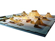
Model of the temple district of Tenochtitlan with the Templo Mayor in the center (Museo Nacional de México, Mexico City). The reconstruction is partly outdated by the excavations in the city center around the Templo Mayor.
Location
Tenochtitlan was located on several islands in the western part of Lake Texcoco, which lies in the Valley of Mexico at an altitude of about 2240 meters. To the north, east and south, the valley is surrounded by a mountain range dominated by the volcanoes Popocatépetl and Iztaccíhuatl. The city was connected to the mainland by five causeways to the north, west, and south. On a neighboring island to the north, separated from Tenochtitlan only by a canal, was the initially still independent city of Tlatelolco.
Today, Lake Texcoco no longer exists in its former extent, as it was gradually drained by the Spanish. Only in Xochimilco, south of today's Mexico City, small bodies of water form a last remnant of the lake.
Structure of the city
The islands on which Tenochtitlan and Tlatelolco were located occupied a total area of about 13 square kilometers. The city was connected to the mainland by five causeways built of stone and earth. They had several breaks, which were closed by movable wooden bridges. The Aztecs took advantage of this fact, especially in 1521, when they defended their city against the Spanish. Since Tenochtitlan could only be reached by causeways and by sea, it had no city walls.
Coming from the north, west and south, the causeways converged on the large marketplace of Tlatelolco and the square in front of the Templo Mayor in Tenochtitlan. This formed the center of the city. Around the square were built the palaces of the rulers Moctezuma I, Axayacatl and Moctezuma II during the history of the Aztecs. The main streets, running at right angles to each other, simultaneously divided Tenochtitlan into the four districts of Moyotlan, Zoquiapan, Atzacualco, and Cuepopan, which in turn were divided into smaller districts. Traffic within the city moved along a maze of alleys and canals. For trade with other settlements, in addition to the causeways, the port in eastern Tenochtitlan was used.
The often multi-storey dwellings of the lower social classes were densely packed; some of them were built on stilts. The residential properties, especially in the outer parts of the city, often had a fenced garden. Behind them were the so-called chinampas, fields that were often only a few meters wide but very long in relation to their width. The chinampas were cultivated areas obtained from the swampy soil, and their favorable soil moisture often made it possible to have several harvests a year. Nevertheless, the chinampas alone were not sufficient to feed Tenochtitlan's ever-growing population. Moreover, as the city and the Aztec empire expanded, land ownership became more and more a privilege of the nobility. However, the proportion of the higher classes in the population was relatively high.
An outstanding importance took the extensive temple district. Around the Templo Mayor, several larger and smaller temples were grouped, which were dedicated to various deities and certain cults of individual social classes. Furthermore, there was a specially created place for the ritual ball game in the temple district.
The northern part of the city was formed by the city of Tlatelolco, which was independent until 1473. The settlement had already been closely linked to Tenochtitlan before its conquest and had been an economic center of the region. After its subjugation by the inhabitants of Tenochtitlan, Tlatelolco largely retained this character; even the Spaniards were impressed by the size and variety of goods in Tlatelolco's market. In all, when the Spaniards arrived, the two now-united cities may have been home to tens of thousands of people, possibly more than 150,000, making Tenochtitlan one of the largest cities in the world at the time.

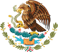
The current coat of arms of Mexico takes up the founding myth of Tenochtitlan: It shows an eagle sitting on a cactus with a snake in its talons.

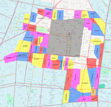
Calpulli (districts) of Tenochtitlan over modern city map. The grey rectangle is the residential district of the Spaniards after the conquest called "traza", the districts located there are not known. Condition at the end of the 18th century.
Questions and Answers
Q: What was Tenochtitlan?
A: Tenochtitlan was the capital city of the Aztec Empire.
Q: When was Tenochtitlan built?
A: Tenochtitlan was built around 1325 by the Aztecs.
Q: Where was Tenochtitlan built?
A: Tenochtitlan was built on a lake called Lake Texcoco.
Q: How did Tenochtitlan grow?
A: Tenochtitlan grew as the Aztec Empire grew.
Q: When did people start living in Tenochtitlan?
A: People started living in Tenochtitlan by the early 1500s.
Q: How many people lived in Tenochtitlan by the early 1500s?
A: By the early 1500s, at least 200,000 people lived in Tenochtitlan.
Q: Was Tenochtitlan the largest city in the Americas before Columbus arrived?
A: Yes, Tenochtitlan was the largest city in the Americas before Christopher Columbus arrived.
Search within the encyclopedia