Tectonics: structure, processes and significance of Earth's deforming crust
Study of the Earth's lithospheric structures and the forces that shape them: plate boundaries, mountain building, earthquakes, volcanism, resource distribution and landscape evolution.
Tectonics is the scientific study of the large‑scale structural features of the Earth and the processes that deform its outer layers. It treats the geometry, distribution and history of folds, faults, plate boundaries and other structural features, and the mechanical and thermal forces that produce them. Crack formation and displacement are commonly described as faulting and folding, processes that control the architecture of continents and ocean basins.
The term derives from classical terminology (from Latin) associated with construction and building, and the subject is a core part of geologic science. Modern tectonics focuses on the behavior of the rigid outer shell known as the lithosphere, how it is partitioned into plates, and the interactions among those plates that produce mountain belts, basins and oceanic structures. Studies of lithospheric structure connect observations at Earth's surface to deep processes in the mantle.
Image gallery
6 Images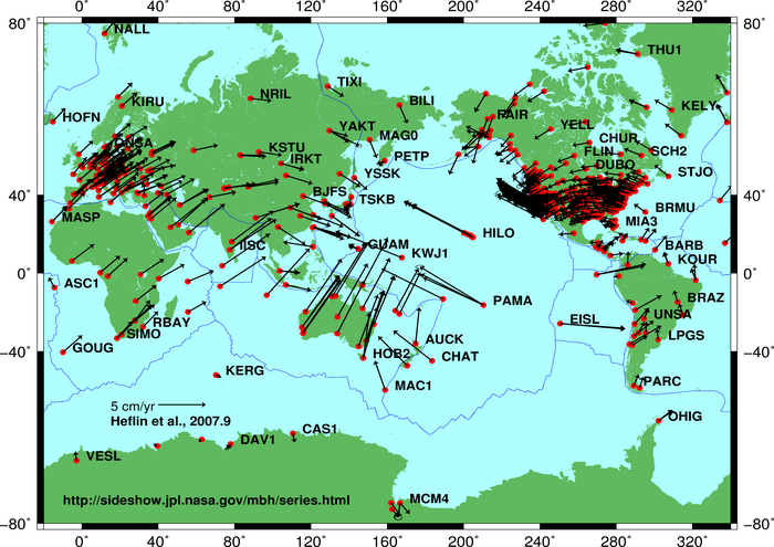
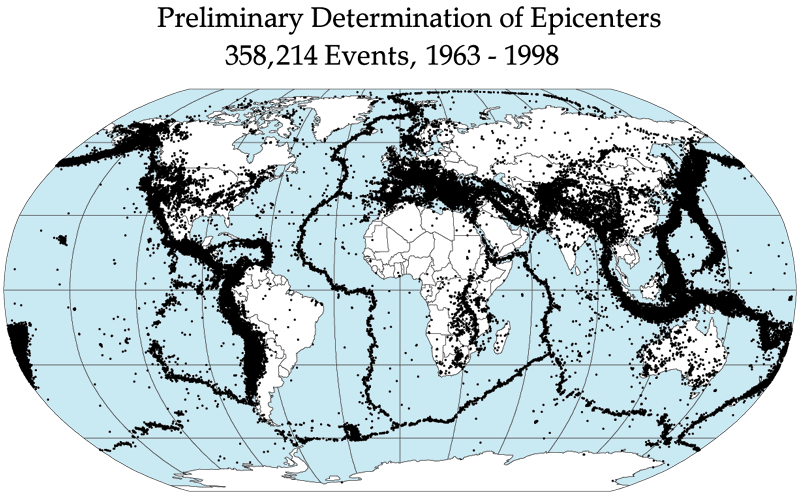
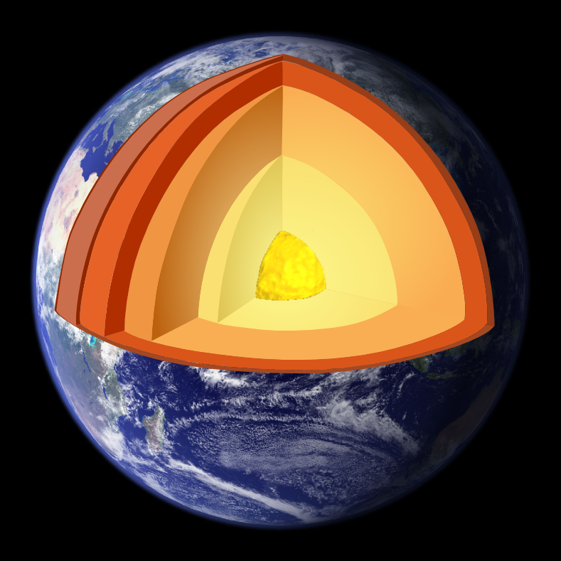
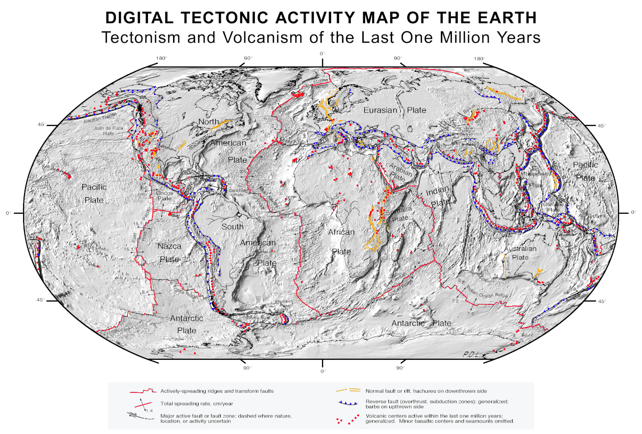


Plate tectonics and types of boundaries
The unifying framework for many tectonic observations is plate tectonics, which describes rigid plates moving relative to one another on a more ductile asthenosphere. Plate boundaries are commonly classified as divergent (where new crust forms), convergent (where crust is consumed and mountain building occurs) and transform (where plates slide past one another). These boundary types help explain the global distribution of earthquakes and volcanism and the lifecycle of oceanic and continental crust.
Processes and surface expressions
Tectonic activity produces a wide range of phenomena. Sudden slip on faults generates earthquakes, while melting and magma ascent near some plate boundaries and hot spots produce volcanism. Long‑term deformation yields folded rock sequences, thrust belts, rift basins and passive margins. Episodes of mountain building, or orogeny, result from continental collision and related processes and commonly involve metamorphism and crustal thickening.
Methods and evidence
Geologists combine field mapping, structural analysis, petrology and geophysics to reconstruct tectonic histories. Seismology and seismic tomography reveal deep structure; GPS and satellite geodesy record present‑day motions; and stratigraphic records show how uplift, subsidence and climate influenced erosion and sedimentation over geological time. Surface processes such as erosion and drainage evolution are closely linked to tectonic uplift and subsidence.
Applications and societal relevance
Understanding tectonics has practical value. Hazard assessment for earthquakes and volcanic eruptions is grounded in tectonic models of active faults and plate boundaries. Exploration for energy and mineral resources uses tectonic and structural frameworks: petroleum systems commonly concentrate in basins formed by tectonic processes (petroleum), while many metallic mineral deposits and ore bodies are associated with deformation, faulting and fluid flow controlled by tectonics.
Scale, time and comparative planetology
Tectonics operates across a vast range of time and space. Plate motions are slow yet cumulative over millions of years, while earthquakes and volcanic eruptions can be abrupt. Comparative planetology applies tectonic concepts to other bodies: Venus, Mars and icy moons show different deformation styles because of different thermal and compositional histories, indicating that tectonic behavior depends on planetary size, heat budget and lithospheric properties.
Current research integrates dense geodetic networks, improved seismic imaging, laboratory studies of rock mechanics and numerical modelling to refine how we understand the coupling between mantle convection, plate motions and surface processes. This interdisciplinary work continues to shape how scientists assess geological hazards, locate resources and interpret the long‑term evolution of Earth’s surface.
- Major components: lithosphere, plates, faults, folds, basins and mountain belts.
- Primary tools: field mapping, seismology, satellite geodesy and laboratory mechanics.
- Applications: hazard mitigation, resource exploration and landscape evolution.
For accessible introductions and deeper reviews, consult authoritative overviews and academic texts or resources from geological organizations (overview, planetary context, structural methods, fault analysis, terminology, geology discipline, lithosphere studies, orogeny case studies, seismicity catalogues, volcanic research, plate tectonics primers, erosion interactions, petroleum systems, mineral deposits, ore geology).
Questions and answers
Q: What is tectonics?
A: Tectonics is the study of the Earth's structural features, particularly the folding and faulting of the Earth's crust.
Q: What is the meaning of the term "tectonics"?
A: "Tectonics" comes from Latin and means "building".
Q: What is included in the field of tectonics?
A: Tectonics includes structures in the lithosphere of the Earth and the forces and movements that have operated to create these structures.
Q: What is the main focus of tectonics?
A: The main focus of tectonics is orogenies (mountain building) and major land features.
Q: What are some specific examples of features that fall under the field of tectonics?
A: The earthquake and volcanic regions that affect certain parts of the world are examples of features that fall under tectonics.
Q: What is plate tectonics?
A: Plate tectonics is a branch of tectonics that deals with the movements and interactions of large sections of the Earth's crust, called plates.
Q: Why is tectonic study important beyond its geological applications?
A: Tectonic studies are important in understanding erosion patterns in geomorphology and as guides for the economic geologist searching for petroleum and metallic ores.
Related articles
Author
AlegsaOnline.com Tectonics: structure, processes and significance of Earth's deforming crust Leandro Alegsa
URL: https://en.alegsaonline.com/art/96700