Bay of Kotor
The Bay of Kotor (Serbo-Croatian Boka kotorska/Бока которска, Italian Bocche di Cattaro) is an almost 30 km long, strongly winding fjord-like bay of the southeastern Dalmatian-Montenegrin Adriatic coast, lined by high and very steep mountain sides.
The bay consists of four individual basins connected by narrow stretches. The two-kilometre-wide inlet with the fortified island of Mamula lies between the fortified peninsulas of Prevlaka (belonging to Croatia) and Cape Arza on the Luštica peninsula. From the outside to the inside follow the basins of Herceg Novi, Tivat and behind the peninsula of Vrmac Risan and Kotor. The basins of Herceg Novi and Tivat are connected by the Kumbor Channel, while the basins of Tivat, Risan and Kotor are connected by the Verige Strait, which is 330 m wide at its narrowest point. The inner bays of Risan and Kotor are UNESCO World Heritage Sites.
The bay, which is strategically well situated and cut more than 1000 m deep into the surrounding karst mountains of Orjen and Lovćen, is also well protected from hurricane-like Bora winter storms and is also naturally favoured in the otherwise waterless karst area by numerous, strongly flowing karst springs. Since antiquity, important cities have developed as cultural and commercial centres, among which the eponymous city of Kotor in the innermost corner of the bay stands out in particular today.
Risan, the oldest place in the bay, is an Illyrian-Greek foundation where remains of the forum and late antique villas can still be found. Roman foundations are Kotor and Rose, in the Middle Ages Herceg Novi and Tivat were founded and from the Venetian era Dobrota, Perast and Tivat.
In addition to the maritime towns, numerous religious foundations in the form of monasteries have sprung up on the shores of the bay. This makes the bay one of the most densely endowed with religious places of worship on the Mediterranean. Places of pilgrimage include the Benedictine monastery of Sveti Đorđe, the Orthodox monastery of Savina, and the Nemanjid foundation of the Monastery of St. Michael on the Isle of Flowers. Important city churches can be found in Kotor, Perast, Herceg Novi, Risan. In addition, there are numerous village churches built in natural stone in the mountain villages of the surrounding mountains, especially in Krivošije.
Ecology
The geographical position on the north-eastern Mediterranean fringe and the mountain relief are decisive for the climate of the bay. The orographic effect of relief and topography of the mountainous hinterland is of particular importance for the climate. In addition to hypsometric thermal change, ventilatory and hydrogeographic conditions are extremely modified. The Bay of Kotor is one of the few Mediterranean transition regions to the laurel forest climate. The special climate can be explained by two reasons: On the one hand, the highest precipitation averages in Europe occur here; the humid warm air masses that glide up in the mountain jam form the subtype of a perhumid southern Adriatic climate variant with extreme annual precipitation amounts of 4,500 to 6,500 mm. On the other hand, precipitation in summer is not uncommon, which means that the summer dry period characteristic of the Mediterranean climate is absent.
| Station | Height [m] | Type | Character | Precipitation [mm] | Snow |
| Risan | 0 | Cs''a | (s''= double winter rainy season), perhumid Mediterranean coastal climate | 3500 | 2 days |
| Crkvice | 940 | Cfsb | (fs= without summer drought), perhumid Mediterranean mountain climate | 4926 | 70 days |
| Zubački kabao | 1894 | D | perhumid Mediterranean snow climate | approx. 6250 | approx. 140 days |
According to Köppen's effective climate classification, the Bay of Kotor belongs to climate type Cs''a. The particular humid character of the Mediterranean hill station Crkvice in Orjen is evident from the climate type Cfsb.
The Orjen Mountains above the bay differ from this mainly thermally, as frost and abundance of snow in winter form a strong contrast to the coastal fringe. Periodic cold-air blasts, which occur on the release of polar cold air over the mountains into the bay by violent bora fall winds in winter, cause a structural change in the vegetation, which is reminiscent of a garigue in appearance, but is floristically characterised by frost-hardy elements.
With the increased cyclonic activity in the Mediterranean, tropical air from Africa and parts of Asia is transported to the Mediterranean, especially from March to May and in autumn. The warm southerly wind is commonly called sirocco and is known as jugo in Dalmatia. If this occurs in the summer months, it comes to the highest temperatures in the Adriatic region.

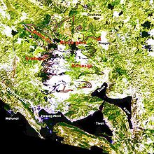
Limits of the maximum glaciation of Orjen during the Riss-Cold period
Population
With 70% urban population, the Bay of Kotor is the most urbanized region in Montenegro. In 1981, only two percent of the people were still employed in agriculture.
The population is predominantly Serbian Orthodox, but many Catholics also live in the towns in the bay.
A historical proper name of the population of the Bay of Kotor is Bokelj, after Boka for bay.
Settlements
Small towns are strung along the shores like pearls on a string, with a total of about 60,000 people living there. In Topla Bay lies Herceg Novi, the largest town on the bay. It lies on the northern shore on the moderately steep slopes of the Orjen Mountains. The old town is surrounded by three forts and medieval walls. In the bay of Tivat is the town of the same name, Tivat. It is of recent origin and an important naval base. It is situated on the gently sloping slopes of the Vrmac Mountains, marked by torrents and torrents. The inner bays are those of Risan and Kotor. Here is the real heart of the bay. The maritime history is immortalized in the old captain's houses and many rich churches in Perast, Dobrota, Prčanj and Kotor.
Since the hinterland with its extreme high karst character is distinctly inaccessible, the nearest settlements outside the bay - with the exception of Cetinje - are far away.

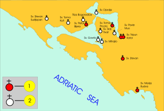
Overview map of the churches 1) Churches from the 9th century 2) Churches from the 10th and 11th century
Search within the encyclopedia