
Tanjore District (Madras Presidency): geography, history and legacy
Former district of the Madras Presidency covering present Thanjavur, Tiruvarur and Nagapattinam areas; a fertile Cauvery delta region, known for rice cultivation and rich Chola and Maratha cultural heritage.
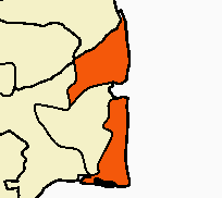
The district historically known as Tanjore (also spelled Tanjavur or Thanjavur) was an administrative division of the Madras Presidency during the period of British India. Its territory corresponded largely to what are today the districts of Thanjavur, Tiruvarur and Nagapattinam together with parts of the Pudukkottai area. Located in the southeast Indian state of Tamil Nadu, the district occupied the fertile alluvial plains of the Cauvery delta and was among the wealthiest agricultural districts in the presidency.
Image gallery
5 Images


Geography and environment
Tanjore District lay largely within the Cauvery river basin, an extensive lowland with rich silt soils that have supported intensive wet-rice cultivation for centuries. The climate is tropical with seasonal monsoon rainfall that sustains the irrigation networks fed by the Cauvery and its distributaries. Coastal segments around Nagapattinam faced the Bay of Bengal and supported fishing and salt-making activities as well as delta agriculture.
History and formation
The modern district was established in 1799 after the Thanjavur Maratha ruler Serfoji II ceded most of his territory to the British East India Company in exchange for formal restoration to his throne under subsidiary arrangements. Earlier layers of political history include the medieval Chola kingdom, whose capital at Thanjavur left a durable cultural and architectural legacy, and later Maratha rule from the 18th century. Under British administration the district became a stable agricultural heartland; its productivity meant it suffered less severely than some other regions during the Great Famine of 1876–78.
Administration and subdivisions
As an administrative unit the district was divided into several taluks and revenue divisions that formed the basis for local government, revenue collection and law enforcement. Major towns included the district headquarters at Thanjavur (Thanjavur), and other commercial and river-port settlements along the delta. Over the 20th century the old district boundaries were reorganized and portions were separated to create smaller civic districts, a process that produced the modern districts named above.
Economy, society and uses
The principal economic activity was wet-rice agriculture supported by an elaborate system of canals and tanks. The delta was often called the "rice bowl" of southern India for its high yields and intensive cropping. Small-scale industries such as handloom weaving, temple-related crafts, fishing and salt production were locally important. Because of its agricultural resilience and networked irrigation, Tanjore was less prone to catastrophic crop failures in the late 19th century than some inland regions.
Culture, monuments and legacy
Culturally the district is renowned for its Chola monuments and classical arts. Thanjavur houses the large Brihadeeswarar Temple, a World Heritage-era monument built in the Chola period that exemplifies the district's long religious and architectural traditions. The region fostered classical Tamil music, painting schools (often called Tanjore painting), and temple-centered social life. The historical district's administrative contours faded after Indian independence, but its agricultural importance and rich cultural heritage continue to define the modern districts that occupy the same landscape.
- Former presidency: Madras Presidency
- Historical capital: Thanjavur
- Territorial successors: Thanjavur, Tiruvarur, Nagapattinam
- Nearby princely territory referenced: Pudukkottai
Questions and answers
Q: What was Tanjore District?
A: Tanjore District was one of the districts in the erstwhile Madras Presidency of British India.
Q: What was the area covered by Tanjore District?
A: Tanjore District covered the area of the present-day districts of Thanjavur, Tiruvarur and Nagapattinam and the Aranthangi taluk of Pudukkottai District in Tamil Nadu.
Q: Why was Tanjore considered a center of Chola cultural heritage?
A: Tanjore was considered a center of Chola cultural heritage because it was home to many historical sites and monuments related to the Chola dynasty.
Q: When was Tanjore district constituted?
A: Tanjore district was constituted in 1799.
Q: Who ceded most of his kingdom to the British East India Company in return for his restitution on the throne?
A: The Thanjavur Maratha ruler Serfoji II ceded most of his kingdom to the British East India Company in return for his restitution on the throne.
Q: What is the geography of Tanjore district like?
A: Tanjore district is situated on the Cauvery Delta and is one of the richest rice-growing regions in South India.
Q: Was Tanjore district affected by famines?
A: Tanjore district was scarcely affected by famines such as the Great Famine of 1876–78.
Related articles
Author
AlegsaOnline.com Tanjore District (Madras Presidency): geography, history and legacy Leandro Alegsa
URL: https://en.alegsaonline.com/art/96292