Tacoma, Washington: Port city, history, and culture on Commencement Bay
Tacoma is a mid‑sized port city in Pierce County, Washington, on Puget Sound. Known as the “City of Destiny,” it has a working port, museums, a university campus, and waterfront renewal projects.
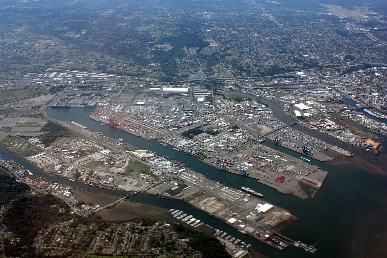
Tacoma is a mid‑sized American city on the shores of Commencement Bay in Puget Sound, located in Pierce County in the state of Washington. It lies roughly southwest of Seattle, northeast of Olympia, and within sightline distance of Mount Rainier on clear days. The municipality is the county seat and, at the 2010 census, had a population of about 198,000 people; residents commonly call themselves Tacomans. The city’s long waterfront, rail connections and industrial base have shaped its economy and identity.
Image gallery
10 Images


Geography and name
Tacoma occupies a coastal plain and low hills at the southern reach of the Salish Sea. Its bay forms a natural deepwater harbor that long attracted maritime traffic and industry. The city’s name is derived from a local Indigenous term for Mount Rainier—often rendered as Tahoma or Tacoma in historical sources—reflecting the mountain’s cultural and visual significance to the region’s Native peoples. The harbor, rivers and rail corridors create a mix of industrial, commercial and residential neighborhoods that link downtown to suburban and rural areas of Pierce County and the surrounding region.
History and development
Tacoma grew rapidly in the late 19th century after it was chosen as the western terminus for a transcontinental railroad, an event that earned it the nickname “City of Destiny.” That decision tied the city’s fate to shipping and freight, and spurred urban and port development. Tacoma has experienced cycles of boom and reinvention: industries and sawmills in the early era; expansion of shipping, rail and warehouses; mid‑20th‑century decline in some neighborhoods; and a concerted revival in the late 20th and early 21st centuries. One widely reported episode in the city’s history is the 1940 collapse of the original Tacoma Narrows Bridge—nicknamed “Galloping Gertie”—which became an instructive case in engineering and aerodynamics and led to changes in suspension bridge design.
Economy and the Port
The Port of Tacoma is a defining economic institution. As a major Pacific Northwest container and bulk‑cargo facility, it handles a range of imports and exports, including automobiles, consumer goods, timber products and grain. Intermodal rail yards and highways connect the port to national supply chains, and warehouses and logistics firms provide significant local employment. The waterfront and industrial districts also support ship repair, fishing, and related maritime services. Over recent decades the city and port authorities have balanced industrial uses with environmental cleanup and redevelopment of former industrial shorelines.
Culture, institutions and waterfront renewal
Tacoma has invested in cultural institutions and waterfront restoration to broaden its economic base and civic appeal. The city hosts several museums—among them museums for contemporary glasswork, regional history and visual arts—along with theaters, galleries and festivals. A downtown campus of the University of Washington, established as part of urban revitalization efforts, expanded higher education and research activity in the city. Major cleanup and redevelopment projects transformed sections of the waterfront such as the Thea Foss Waterway into marinas, parks and mixed‑use districts, while streetcar service and pedestrian investments improved downtown access.
- Notable cultural sites: museum complexes, performing arts venues, and community galleries.
- Education: branch campus and vocational training that link to local industries; see the campus page: UW Tacoma.
- Waterfront projects: habitat restoration, marina development, and public promenades.
Transportation and notable features
Tacoma is served by regional highways and freight corridors; the Tacoma Narrows Bridge carries vehicular traffic to the Kitsap Peninsula. The city lies within the greater Seattle–Tacoma metropolitan area and is linked to the region’s primary airport, whose IATA code is SEA, located near the city of SeaTac. Local transit includes buses, a short electric streetcar line that facilitates downtown circulation, and freight rail connections that remain essential to the port and industry.
Tacoma’s civic story is one of industrial roots and ongoing reinvention. Recognitions for walkability and livability appear alongside reminders of urban challenges from earlier decades; social, environmental and economic indicators have varied across neighborhoods and over time. For historical population and urban data, local and federal sources provide context and trend analysis: see demographic summaries at the census and regional data pages. For broader context about the state and region consult resources about Washington and the Pacific Northwest.
Visitors and residents encounter a city that combines working port infrastructure with cultural institutions, a visible mountain backdrop, and neighborhoods shaped by both maritime commerce and contemporary urban design. From legacy industrial sites to renovated waterfront districts, Tacoma continues to balance its role as a regional logistics hub with efforts to expand cultural, educational and recreational opportunities for a diverse population.
Geography
Geographical position
Tacoma is located in the northwest of the USA in the state of Washington, on Commencement Bay, a bay in Puget Sound between Seattle in the northwest (51 km) and Olympia (50 km) at the southern end of the sound. To the west are the Olympic Mountains, to the east the Cascade Mountains with Mount Rainier. This is a part of the so-called Pacific Northwest. Tacoma is the capital of Pierce County.
The city's largest river, the Puyallup rises in the Cascade Mountains at Mount Rainier and empties into Commencement Bay in the harbor area. The Puyallup is approximately 45 miles (72 km) long and carries approximately 80 cubic yards of water per second. Other smaller rivers and creeks include: Wapato Creek, Hylebos Creek.
The city rises from the bay to 482 feet (146.9 m) in elevation. The total area of the city is 162.2 km², divided into 129.7 km² of land mass and 32.5 km² of water. This makes one-fifth of the city's total area water. Tacoma is the largest city in Pierce County and third largest city in the state. Visible almost from the entire city limits, Mount Rainier, the active and potentially most dangerous volcano in the Cascade Range, is an integral part of the cityscape. In the event of a volcanic eruption, parts of the city, particularly around the harbor, are at risk of flooding and mudslides. Volcanic ash is another hazard that can reach large areas in the Tacoma area. Volcano Evacuation Routes have been established for effective evacuation and are indicated by special road signs.
Geology
Tacoma lies on the North American Continental Plate, in the lowland "Puget Lowland" on Quaternary deposits up to one kilometer thick. The Juan de Fuca Plate dips under the North American Plate (subduction).
To the east is the Cascade Mountains with the active volcano Mount Rainier. The proximity to this mountain range, especially Mt. Rainier, poses a potential earthquake hazard. An eruption of the stratovolcano poses a major threat to Tacoma from mudslides to the urban area around the Puyallup River and to the entire city from ashfall.
The urban area is characterised by lowlands, the so-called tidal flats in the east and hilly landscape in the north, west and south with sometimes very steep slopes, especially in the city centre.
Earthquake
| Notable earthquakes since 1946 | ||
| Name of the earthquake/location | Date | Strength |
| Straits of Georgia | 23 June 1946 | 7,3 |
| Olympia | April 13, 1949 | 7,0 |
| Tacoma | 29 April 1965 | 6,5 |
| Nisqually | 28 February 2001 | 6,8 |
| by way of comparison | ||
| San Francisco | April 18, 1906 | 7,8 |
Neighboring communities
Tacoma borders the following neighboring communities:
| West of Tacoma:
East of Tacoma:
| North of Tacoma:
South of Tacoma:
|
City breakdown
Districts and neighbourhoods
- Central Tacoma
- Hilltop: Boundaries: 6th Avenue to the north, 25th Street to the south, Yakima Avenue to the east, and Sprague Avenue to the west. Historically, Hilltop has been an African-American neighborhood. This neighborhood was named for its location on a hill above Commencement Bay and the harbor. The Tacoma Public Library headquarters, Bates Technical College, the Pierce County Courthouse, and the Pierce County Correctional Facility are located in Hilltop. In the late 1980s and early 1990s, the Hilltop neighborhood had major problems with crime, particularly gangs such as the West Coast Crips, and drugs, especially cocaine. Since the mid-1990s, these problems have been mitigated by neighborhood watch, a civilian neighborhood patrol, increased police presence, and increased investment in commercial buildings, some of which have been relocated to other parts of the city. The center of gang activity is currently the eastern neighborhoods.
- Downtown Tacoma: Borders: Between Pacific Avenue and St. Helens Street. The focal point of Downtown Tacoma is the intersection of 9th Street and Broadway, with three theaters. The Tacoma Convention Center, the Rialto Theater, the Pantageous Theater, the Theater on the Square, and the Bostwick Building are prominent buildings in the district. The city's Christmas tree is also erected annually in Downtown Tacoma. The Tacoma Convention Center was built in 2004 at a cost of $84 million and is considered the most important factor in accelerating the revitalization and modernization of the district. The district is known for other historic buildings, such as the former Union Station, the Winthrop Hotel, and Old City Hall. Furthermore, many dining establishments can be found in Downton Tacoma, especially on Pacific Avenue.
- Stadium District (shared with "North End"): Boundaries: Between "North Slope" and Hilltop. The Stadium District is a historic neighborhood of Tacoma, consisting primarily of businesses and apartment buildings. It is home to The Tacoma Little Theatre, Tacoma's Landmark Temple Theatre, and Stadium High School, among others.
- Eastside
- Dome District
- McKinley Hill
- Salishan: Salishan was created after World War II to provide affordable rental housing for military personnel, veterans and their families. Tacoma was a primary location for this due to its proximity to U.S. Army Fort Lewis and McChord Air Force Base. The remaining portions were bought out by the Tacoma Metropolitan Park District and Swan Creek Park. Salishan is a neighborhood that is very poverty stricken. 57.4% of Salishan residents, 64.5% of those under 18, and 52.6% of those over 65 live below the poverty line. 43.2% are single parents. 53.53% are Asian, 10.81% are African-American, and 23.55% are so-called white.
In 2001, the city received $35 million from the HOPE VI program to redevelop the district and make it safer. A $200 million redevelopment plan was created. This plan calls for the complete demolition of existing housing and replacement with 1200 new homes in a mix of owner-occupied and rental properties. This plan also includes a new hospital, technology center and several child care facilities. The focus of the project is to transform the area into a more urban environment with green spaces.
- Northeast Tacoma: Boundaries: The Port of Tacoma to the southwest, the village of Fife (Fife Heights) to the southeast, Browns Point to the northwest, and King County to the northeast form the boundaries of Northeast Tacoma. Separated from Tacoma by the waterfront, Northeast Tacoma has the character of a satellite city. Over the past several decades, the neighborhood has grown steadily and has had a major impact on increases in Tacoma's population. Northeast Tacoma is Tacoma's most affluent neighborhood. Due to its hillside location, many homes have excellent views of Commencement Bay. At 146.9 meters (482 feet) above sea level, Indian Hill is Tacoma's tallest elevation.
- Browns Point (unincorporated): Boundaries: To the southeast, Northeast Tacoma forms the boundary; to all other sides, Puget Sound. Browns Point was named for Alvin Harris, a sailmaker on the Wilkes Expedition. The most prominent point is the lighthouse, built in 1887, rebuilt in 1933 and fully automated in 1963. The tower and nearby cabin have been added to the American Register of Historic Places.
- Crescent Heights
- South End
- South Tacoma
- Fern Hill: Boundaries: Fern Hill is bounded by South 72nd Street to the north, the city limits at 96th Street to the south, South Sheridan Ave to the west, and Pacific Avenue to the east. Fern Hill is home to a branch of the Tacoma Public Library, a large church, an elementary school, and several stately historic buildings, among others. Fern Hill has three parks within three blocks of each other.
- West Tacoma
- North Tacoma: Boundaries: 6th Avenue to the south and Division Avenue to the east. To the north and west, North Tacoma borders Commencement Bay. Compared to the other neighborhoods, North Tacoma is more affluent and is largely made up of members of the middle class. North Tacoma was traditionally a lower middle class neighborhood, with many fishermen living there. Although North Tacoma is often considered a satellite neighborhood of Seattle, most North Tacoma residents work in Tacoma itself, an unusually high number in occupational fields such as education, health, and social services. Politically, North Tacoma is overwhelmingly close to Democrats, nationally, statewide, and locally.
- North Slope: boundaries: There are no defined boundaries for this district; often the transition, especially toward Yakima Hill is fluid. Commonly assumed boundaries are North I Street to the northeast, Division Avenue to the southeast, 6th Avenue to the south, and Steele Street to the west. The neighborhood is relatively affluent and has a population of upscale educational standards.
- Old Tacoma: Old Tacoma is referred to as Old Town in Tacoma's daily life. Historic 1880s buildings and cobblestone streets justify the name. The replica of Job Carr's cabin was built here and Tacoma's first church was also built here. There is a healthy mix of retail and offices here. Plus, Old Tacoma has a particularly good view over Commencement Bay.
- Proctor District: The Proctor District is home to some unique retailers, banks, and shops for everyday necessities. The district retains a small town feel within Tacoma. The Blue Mouse Theatre, a small movie theater, opened on November 23, 1923.
- Prospect Hill: Due to its location overlooking the bay, this is also home to the most expensive houses in the city, although only a few properties have a really good view.
- Ruston (independent) Boundary: Completely surrounded by Tacoma, with Commencement Bay forming a natural end to the northeast. Ruston is not actually a neighborhood of Tacoma, but a legally separate municipality; however, the majority of Ruston residents consider themselves fellow citizens of the City of Tacoma. Ruston is often referred to as the North End of Tacoma.
- Ruston Way: Ruston Way is a popular destination for walks along Commencement Bay and a gathering place for Tacoma's youth in the summer.
- Skyline: Skyline is sometimes called "Narrows View", a reference to the view of the Tacoma Narrows. The center is Skyline Drive.
- Stadium District (shared with "Downtown Tacoma"), see above
- Yakima Hill: Boundaries: North I Street to the south-southwest, Tacoma Avenue to the north-northeast, North Borough Road to the west, North Stadium Way to the north, and North 3rd Street to the east. Yakima Hill is a quiet, fairly affluent neighborhood. Most of the development is residential. Annie Wright School and a private tennis club.
Military facilities
Several military installations are located near the city limits:
- Fort Lewis (Army)
- Madigan Army Medical Center
- McChord Air Force Base
Climate
Tacoma is located in the temperate zone. In general, the climate is temperate, with humid winters and pleasant summer temperatures that can reach and exceed 30°C. The Pacific Ocean is the main influence on the climate. The climate is mainly determined by the Pacific Ocean and produces abundant winter precipitation. The climate region is called the Puget Lowlands. As part of the Pacific Northwest, the famous rain is also found here, but to a lesser extent than commonly thought. The average rainfall in Tacoma is only 37 inches (94 centimeters), which is less than other metropolitan areas in the United States. Most of the precipitation falls in the winter months, and the average maximum temperature is 7 °C. In the summer, the average maximum temperature is 24 °C (75 °F) with low humidity.
The proximity to the Pacific Ocean and the Cascade Range contributes to the mild climate. The number of sunny days averages 141 per year.
Table
| Monthly average temperatures and precipitation for Tacoma
Source: lwf.ncdc.noaa.gov - climate-monitoring | |||||||||||||||||||||||||||||||||||||||||||||||||||||||||||||||||||||||||||||||||||||||||||||||||||||||||||||||||||||||||||||||||||||||||||||||||||||||||||||||||||||||||||||||||
Weather events
On October 12, 1962, the most powerful storm ever hit Tacoma. This has been called the mother of all storms of the century. Wind speeds of up to 88 mph (140 km/h) were recorded in Tacoma, and up to 150 mph (240 km/h) in other areas. This event is called The Columbus Day Wind Storm.
The storm claimed a total of 46 lives, 235 million US dollars in damage to buildings in an area from California to British Columbia, Canada. 35,396,000 m³ of timber with a value of US$ 750 million at the time fell victim to the storm.


History
The Tacoma area was first settled by Native Americans, primarily the Puyallup tribe. Various European explorers made voyages to the Tacoma area, including George Vancouver and Charles Wilkes, who named many landmarks (including Mount Rainier) and drew the first maps.
Job Carr, a Civil War veteran, Quaker, pioneer and postal employee, settled Tacoma Christmas 1864 as one of the first. He built his cabin where Old Tacoma is now. In the Indian language the area is called Shu-bahl-up, the protected place. The first sawmill was built in 1852 by Nicholas Delin, a native of Sweden. It had a capacity of about 2000 feet (600 meters) per day. Delin and Carr were the only whites in the area at that time.
Hoping to profit from rising land prices upon completion of the proposed intercontinental railroad with the terminus at Commencement Bay, although at the time no one knew where the terminus would be for the rail line authorized by President Abraham Lincoln.
Another investor was Matthew Morton McCarver, who among other things bought about four acres of land from Job Carr, who kept about two acres.
The first ship to call at the new settlement had to be guided by burning tree stumps and gunfire, as the town was still very small at the time and the ship's officers could not find their way. It was on this ship that McCarver's later son-in-law, Clinton P. Ferry, reached the new settlement. Ferry founded the Ferry Museum and left two-thirds of his estate to the museum for maintenance. Ferry liked to be called the Duke of Tacoma Three other San Francisco investors established the "Hanson Ackerson & Co." sawmill right on the water line. About 40,000 feet (12 km) of lumber were sawed per day. The first hotel was established by Janet Elder Steele and her husband. The 24 room hotel opened in February 1869 and operated successfully for 15 years. In the fall of 1868, the town consisted of Job Carr's cabin and two buildings under construction, the Steele Hotel and the Hanson Ackerson & Co. sawmill. McCarver named his town "Commencement City," Phillip Ritz, a nursery owner for whom the town of Ritzville, Washington was named, suggested that the town be named Tacoma. Ritz was inspired by the book Canoe and Saddle by Theodore Winthorp. Ritz brought the black poplar (Populus nigra Italica) to the Pacific Northwest.
The name Tacoma was officially adopted after a meeting with McCarver's banks and McCarver commissioned C.P. Ferry to change the name on the map. This map can be seen today at the Ferry Museum. On December 16, 1873, Job Carr, "Skookum Smith," McCarver, General Sprague, and John Ralston pounded the final nail to complete construction of the railroad from Kalama to Tacoma.
In 1874, Jobb Carr and his son Howard, among others, represented Old Tacoma in negotiations with New Tacoma representatives to unite the two parts into one city. Jobb Carr was elected president of the five Old Tacoma representatives. This makes him, in the broadest sense, the first mayor of Tacoma, in addition to his positions as first postmaster and first notary public. McCarver did not live to see Tacoma's official founding, passing away in April 17, 1875, after contracting a severe cold while on his way to newly discovered coal deposits on the Puyallup.
The first local newspaper, The Pacific Tribune, was published on August 9, 1873 by Thomas Prosch, the paper appeared every evening. The last issue appeared already on June 11, 1875, Prosch moved the headquarters of the newspaper to Seattle and changed the name to Seattle Pacific Tribune. After a little more than a year, this newspaper was also discontinued. Thomas Prosch then became editor of the Seattle Post-Intelligencer newspaper. Job Carr's daughter Marietta and her young son died in the sinking of the ship Pacific in Juan de Fuca Strait on October 8, 1875. The Pacific sank after a collision with the ship Orpheus; 273 of the Pacific's 275 passengers died in the accident.
A replica Job Carr's shack, which also served as Tacoma's first post office (opened March 25, 1869), was built in 2000 in the "Old Town" neighborhood near the former site, between Carr Street and McCarver Street. Carr's son Anthony was entrusted with delivering the mail between Steilacoom and the new post office. Job Carr's grandfather, Colonel Caleb Carr became the first governor of the state of Rhode Island on the East Coast of the United States after the Civil War.
Tacoma was officially founded on November 12, 1875, with the first settlement established in 1864. Tacoma's predecessor, Commencement City, was founded in 1868. In 1873, the Northern Pacific Railway opened a station called New Tacoma near the settlement, above the "tideflats" of the existing settlement. Nicholas Delin tried to convince McCarver to build the settlement where the new station was built, but McCarver believed his chosen location was the better one. This left everyone who had invested in Commencement City/Old Tacoma before the location of the station was determined with little profit. In 1883 the two towns were united under the name of Tacoma. The hopes for prosperity placed in the railroad, hence the epithet "City of Destiny," were permanently shaken by the Klondike River gold rush of the late 19th century. Seattle, unlike Tacoma, benefited greatly from this boom.
In 1880, George Francis Train made a round-the-world trip starting (March 18) and ending (May 24) in Tacoma to set a new speed record and to highlight Tacoma's central location. His record attempt took exactly 67 days, 18 hours, 2 minutes and 55 seconds. Today, a plaque with the start and finish points downtown commemorates this early promotional effort. Several thousand Chinese living peacefully in Tacoma were driven from the city in November 1885, and on November 4, 1885, 2 Chinese settlements burned to the ground. This action, led by the mayor at the time, is now called the Tacoma Method.
On 26 December 1886, electric street lighting was put into operation for the first time. 36,000 inhabitants were counted in 1890.
In 1893, at a meeting of the Loyal Legion of the United States, a resolution by Civil War veteran Russell G. O'Brien was approved in which he requested that all members of the Legion stand and remove their headgear at the sounding of the national anthem. This behavior soon became a tradition throughout the United States of America.
In the winter of 1929/1930, the city suffered from a 30-day power outage. The aircraft carrier Lexington supplied the city with electricity using on-board generators. The Navy received a sum of 60,000 US dollars for this.
During World War II, a total of 74 warships were launched in Tacoma's shipyards, with more than 30,000 workers engaged in production at peak times.
The Tacoma Narrows Bridge, also known as the "Gallopping Gertie", collapsed on November 7, 1940, four months after its opening, and was not rebuilt until 10 years later, a necessity as the population on the Key Peninsula opposite Tacoma steadily increased, and with it the number of vehicles. After initial planning began in 1998, a parallel bridge was built from October 2002 to June 2007, with a grand opening on July 16, 2007, as the old Tacoma Narrows Bridge and Stateroute 16 could no longer handle the ever-increasing traffic and seismic safety regulations. The project was completed in the summer of 2008 with the rehabilitation and seismic retrofit of the old bridge structure, now using one bridge in each direction of travel, the original south-north bridge and the new north-south bridge structure. The project cost a total of $849 million. The new bridge has a toll plaza on the Kitsap side. The new bridge construction is designed to last until 2070, while the rehabilitation of the old bridge should extend its life until 2030.
The "Port Industrial Waterway" bridge, called "Blair Bridge", was built in 1953 and was closed and demolished in 1997 due to the expansion of the "Blair Waterway", because the opening of the bridge with about 46 m (150 feet) was no longer sufficient for the increasingly larger ships. The bridge spanned approximately 300 feet (91 m) of waterway.
Cheney Stadium opened in 1960 after only three months of construction. The baseball stadium has been home stadium in Minor League Baseball (Pacific Coast League) for seven teams since its opening, since 1995 for the Tacoma Rainiers, who are part of the Seattle Mariners.
The nation's first moving walkway began operation in Tacoma on February 27, 1961.
In 1998, installation of fiber optic lines began throughout the city. The city-owned company "City of Tacoma Power" thus lifted Tacoma to No. 1 in the list of cities most densely supplied with optical data lines; Tacoma is called America's "most wired city". The investment was over $100 million. Approximately 700 miles (1,127 km) of cable were installed, and telecommunications companies Qwest and AT&T increased the investment by over $200 million for extensions throughout Pierce County.
Tacoma has an extensive system of tunnels underneath many streets, created by the Chinese population. These officially inaccessible tunnels have been partially explored by adventurers. There are said to be tunnels from the stadium to the Tacoma General Hospital.
Historical objects
- Tacoma is home to the historic Nisqually Power Substation (also known as the Tacoma Substation & Storage House), a substation built in 1911. The two buildings were listed as historic landmarks by the National Register of Historic Places on April 25, 2001, with the number 01000429.
- The historic Fireboat Station (also known as Fire Station No. 18) in Tacoma is located at 302 East 11th Street. It was recorded by the NRHP in 1986 (NRHP 86000978).
Renaissance of the city centre
In the last 15 years, the city has made great efforts to improve its appearance and especially to revitalize the downtown area. In 1990, the University of Washington opened a branch in Tacoma and the historic Union Station was restored. The "Museum of Glass" opened in 2002 and displays glass art by local and international artists. A fully functioning glassblowing workshop is part of the museum. Work is currently underway on an automobile museum, Harold LeMay America's Car Museum near the Tacoma Dome. The Tacoma Convention and Trade Center, a modern steel and glass structure, opened in June 2004. In 1996, the Washington State Museum of History opened in the so-called "Cultural District," and in 2003, the Tacoma Museum of Art opened. Since 2002, interest in residential and commercial buildings downtown has been steadily increasing, with real estate prices rising at the same rate.
In 2004, Tacoma was ranked among the top 30 cities for best places to live. This annual survey is conducted by Partners for Livable Communities.
Population development
|
|
Source:
Demographics
Whites make up 69.08% of the population, according to the 2000 U.S. Census, and African-Americans make up 11.24%. In 2000, there were 76,152 households in Tacoma, 30.9% with children under 18. 41.6% were married couples; 31.7% were single households. Of these single households, 10.4% were 65 years or older. The average number of persons per household was 2.45 and the average family size was 3.10. 25.8% of residents were under 18 years of age, 10.4% from 18 to 24 years of age, 31.6% 25 to 44 years of age, 20.3% from 45 to 64 years of age, and 11.9% 65 years of age or older.
The per capita income was US$ 19,130, the median income was US$ 27,697 for the female and US$ 35,820 for the male part of Tacoma's population. 11.4 % of the families, 20.6 % under 18 years of age and 10.9 % of those over 65 years of age lived below the poverty line.


Related articles
Author
AlegsaOnline.com Tacoma, Washington: Port city, history, and culture on Commencement Bay Leandro Alegsa
URL: https://en.alegsaonline.com/art/95843
Sources
- ofm.wa.gov : "April 1, 2017 Population of Cities, Towns and Counties"
- tools.usps.com : "Zip Code Lookup"
- geonames.usgs.gov : "US Board on Geographic Names"