Szczecin
![]()
The title of this article is ambiguous. For other meanings, see Szczecin (disambiguation).
Szczecin (Polish Szczecin [ˈʂt͡ʂɛt͡ɕin]; ![]() ) is the capital of the Polish West Pomeranian Voivodeship. The county-free metropolis with a population of just under 410,000 is the seventh largest city in Poland. It forms the focal point of the German-Polish conurbation of Szczecin with about 780,000 inhabitants, which is to be developed into a European metropolitan region with about one million inhabitants.
) is the capital of the Polish West Pomeranian Voivodeship. The county-free metropolis with a population of just under 410,000 is the seventh largest city in Poland. It forms the focal point of the German-Polish conurbation of Szczecin with about 780,000 inhabitants, which is to be developed into a European metropolitan region with about one million inhabitants.
With three state universities, the University of Szczecin, the Szczecin University of Technology and the Medical University of Szczecin, the university city is an important research and higher education location. In addition, Szczecin is home to numerous vocational schools, art academies and a private business school.
Historically, culturally and touristically significant landmarks of Szczecin are, among others, the Griffin Castle and St. Jacob's Cathedral in the Old Town, the Philharmonic Hall and the Hook Terrace with the National Museum. The best-known sports club in the city is the Pogoń Szczecin football club, and rowing is also very important. Until 1945, Szczecin belonged to Germany.

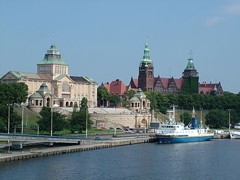
Hakenterrasse (Polish Wały Chrobrego) on the west bank of the Odra river
Geography
Location and special features
Szczecin is located near the southern coast of the Baltic Sea at the mouth of the Oder River in the Szczecin Lagoon, about 105 km southeast of Greifswald, 125 km northeast of Berlin, and 151 km southwest of Koszalin (Köslin). The city area with its suburbs in the west borders on the states of Mecklenburg-Western Pomerania and Brandenburg. Szczecin is thus the largest city within this radius of Berlin, ahead of Magdeburg and Potsdam. The larger Leipzig is half the distance from Berlin.
Szczecin and the Powiat Policki (Pölitzer Kreis), also located west of the Oder, had belonged to Western Pomerania since the Peace of Westphalia of 1648, but the cultural border between Western and Western Pomerania lay further west. The "Stettiner Zipfel" (Szczecin corner) created by the 1945 border demarcation had predecessors before the western expansion of Pomerania (since 1121). In the east, the city area extends over the Oder River. The part of the West Pomeranian Voivodeship east of the Oder includes large parts of the historical Hinterpommern and the northern half of the former Neumark.
Traffic routes
As an old Hanseatic city, Szczecin has one of the largest seaports in the Baltic Sea region. It is also widely connected by air via Szczecin-Goleniów International Airport and by rail via the Szczecin Główny railway station.
Oder estuary
Most of the city is located on the left bank of the Western Odra River, which is characterized by wooded hills, especially in the north of the city. The districts of Dąbie (Altdamm), Podjuchy (Podejuch) and Kołbacz (Colbatz) east of the Odra River are also surrounded by wooded areas of the Buchheide (Puszcza Bukowa, up to 149 m above sea level) and the Gollnower Heide (Puszcza Goleniowska).
Between these two compressive moraines runs the up to five-kilometre-wide river valley - bordered by the main arms West Oder and Ostoder (Odra Zachodnia and Odra Wschodnia). The Odra river, divided into numerous arms with numerous river islands, reaches into the city area. Immediately south of the city begins the German-Polish international park Lower Oder Valley, which consists of the Polish Landscape Park Lower Oder Valley and the German National Park Lower Oder Valley and extends over Schwedt/Oder to near Hohensaaten.
North of the core city the Odra river widens into a large inland lake, the Damm Lake (Jezioro Dąbie). At Police (Pölitz) the river finds its way back into a (very wide) bed before it widens again (Roztoka Odrzańska) and flows into the Szczecin Lagoon at Trzebież (Ziegenort). Via the Kanał Piastowski (Kaiserfahrt) and the Swine (Świna), the open Baltic Sea is reached at Świnoujście (Swinemünde).
Szczecin River Islands
In the narrower city area there are numerous river islands between the two main branches of the river, the Westoder (Odra Zachodnia) and the Ostoder (Odra Wschodnia), as well as the old cross connections Parnitz and Dunzig:
- Directly opposite the Old Town is the island of Lastadie (Łasztownia), which is reached via the Most Długi (translated as "Long Bridge", formerly Hansa Bridge). The Łasztownia district borders directly on the area of the seaport. The island is crossed, without connection to its road network, by the Trasa Piotra Zaremby expressway, which, starting north of the Old Town as Trasa Zamkowa (Castle Road), crosses East and West Oder.
- North of it, between the West Oder, Duńczyca and the Oder-Dunzig Canal (Kanał Grodzki), lies the small, undeveloped island of Schlächterwiese (Wyspa Grodzka).
- South of Lastadie lies the island of Silberwiese (Kępa Parnicka), surrounded by Westoder, Grüner Graben (Kanał Zielony) and Parnitz (Parnica). Silver Meadow is completely built-up, and the island used to be connected to the main railway station directly opposite by the railway station bridge; today the bridge only reaches as far as the small Ahrensinsel in the Westoder. By further bridges the Silberwiese is connected with Lastadie and with the Neue Silberwiese.
- The adjacent New Silver Meadow (Wyspa Zielona) to the south is only built on to a small extent; the island was created by the construction of the Parnitz culvert.
- East of the Parnitz crossing is the island of Vorbruch (Wyspa Pucka), which is separated by the pre-flood channel (Kanał Rybny) of the larger island of Zaleskie Łęgi. This channel branches off upstream from the West Oder to the Port Lake (Jezioro Portowe) and leads from it downstream to the Parnitz. Wyspa Pucka is built-up only in the north (former settlement Vorbruch) and otherwise largely covered by allotments.
- Zaleskie Łęgi is the largest island of the 80 km long island area called Międzyodrze between the lower reaches of the rivers Westoder and Ostoder. It is dominated in the north by port and railway facilities on the Parnitz River. This includes the Szczecin Port Centralny railway station on the northernmost railway line across the Oder. This area is connected to the west bank of the Odra River by the Trasa Piotra Zaremby (part of Highway 10) and to the east bank by two parallel bridges. On the southern border of Szczecin, the island ends at the Kanał Lesny (transl.: Forest Canal). On the northern bank of the canal, the Poznań-Szczecin railway line and the Autostrade Poznańska motorway (part of trunk road 31) cross the island, the latter without connection to the local road network.
- North of Lastadie lies the Grabower Werder (Wyspa Ostrów), which originally had a roughly triangular shape and was bordered by the Westoder, Dunzig and Möllnfahrt rivers. As the island is situated in the middle of the area of the seaport, the arms of the river were greatly altered during the construction of the harbour basins. Thus, part of the Dunzig was filled in, creating a direct land connection with Lastadie. The Wroclaw Navigation (Kanał Dębicki), which was open to the north, thus became a dead end. The Oder-Dunzig Canal to the west of the island cut off the already mentioned Butcher's Meadow. The Dunzig-Parnitz Canal created a connection between the two arms of the river. In the west of the Grabower Werder allotments and forest are predominant.
- To the north of it lies the Bredow embankment (Wyspa Gryfia), which is entirely occupied by the port. It is surrounded by the West Odra River to the west, and the Grabow Ride (Kanał Grabowski) and the Odra Ride (Przekop Mieleński) to the east.
- The adjacent islands of Schwarzer Ort (Czarnołęka) and Großer Oderbruch (Wyspa Dębina) to the north already lie in the Damm Lake.
- In the estuary area of the Ostoder into the Dammsche See there are two more islands. The northern island Mönne was a nature reserve until 1945. In the south-western corner of Mönne was one of the oldest bird and nature conservation stations in Germany, the Naturwarte Mönne. On the foundation of the station building, which was destroyed in 1945, there is now a memorial plaque in Polish and German commemorating the founder of the observatory, Paul Robien. The island is now called Wyspa Paula Robiena after him.
Climate table
| Szczecin | ||||||||||||||||||||||||||||||||||||||||||||||||
| Climate diagram | ||||||||||||||||||||||||||||||||||||||||||||||||
| ||||||||||||||||||||||||||||||||||||||||||||||||
| Monthly average temperatures and precipitation for Szczecin
Source: wetterkontor.de | ||||||||||||||||||||||||||||||||||||||||||||||||||||||||||||||||||||||||||||||||||||||||||||||||||||||||||||||||||||||||||||||||||||||||||||||||||||||||||||||||||||||||||||||||||||||||||||||||||||||||||||||||||||||||||||||||||||||||||||||||||||||||||||

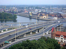
View over the West Odra river and four Odra islands: Duńczyca (Dunzig), on the left Wyspa Grodzka (Butcher's Meadow), on the right the port facilities in Łasztownia (Lastadie) and Ostrów Grabowski (Grabower Werder).
Administrative
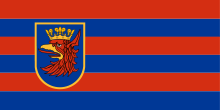
Blazon: "Within a golden fringe in blue a torn gold-crowned, gold-armed, red griffin's head with red tongue out."
The coat of arms of the city of Szczecin shows the head of the red griffin, the heraldic animal in the coat of arms of Pomerania, with the golden crown in the blue field. The content of the coat of arms did not change after the Second World War. In this official form, the coat of arms is also found on the city flag of Szczecin.

City flag Szczecin
Questions and Answers
Q: What is Szczecin?
A: Szczecin is a large city in Poland in West Pomeranian Voivodeship.
Q: How many people live in Szczecin?
A: As of 2005, 411,119 people live in Szczecin.
Q: Where is Szczecin located?
A: Szczecin is located in Poland and is situated on the river Odra (German: Oder), near the border to Germany.
Q: What is one of the largest sea ports on the Baltic?
A: Szczecin is one of the largest sea ports on the Baltic Sea.
Q: What is the historical capital of the German province of Pomerania?
A: Szczecin is the historical capital of the German province of Pomerania.
Q: What is the biggest harbour on the Baltic Sea?
A: Szczecin has got one of the biggest harbours on the Baltic Sea.
Q: What district town borders with Szczecin at the Oder River?
A: Police, a district town, borders with Szczecin at the Oder River.
Search within the encyclopedia