Suez Canal: history, route, and global significance
Artificial sea-level waterway in Egypt connecting the Mediterranean and Red Seas; built in the 19th century, expanded and modernized since, and vital to global maritime trade and geopolitics.
Overview
The Suez Canal is a man-made, sea-level waterway across Egypt that links the Mediterranean Sea and the Red Sea, providing the shortest maritime route between much of Europe and South and East Asia. Known in Arabic as Qanā al-Suways and in French as Le Canal de Suez, it lies west of the Sinai Peninsula and runs roughly north–south between the cities of Port Said and Suez. By avoiding the long circumnavigation of Africa, the canal dramatically shortens voyage distances and remains one of the world’s busiest commercial passages.
Image gallery
10 Images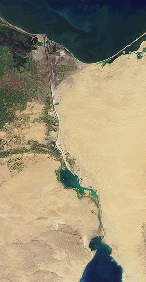


Route and characteristics
The canal follows a relatively straight course across the Egyptian isthmus. Its dimensions vary along the route: at several constricted stretches the navigable channel narrows, while turn basins and passing lanes allow limited two-way traffic. The waterway is operated as a single, continuous sea-level channel without locks, and it is maintained and managed by the Egyptian state authority responsible for navigation, pilotage and toll collection.
History and development
Construction began in the mid-19th century under a company organized by French interests; work started in 1859 and the canal opened in 1869. The project was a major engineering and financial undertaking that reshaped global shipping. During the 20th century the canal was the focus of international disputes and national policies: it was nationalized by Egypt in 1956, an event that precipitated the Suez Crisis, and it was closed for several years after regional hostilities in 1967, reopening in the 1970s. In recent decades the channel has been widened and deepened at intervals, including a major expansion project completed in the 2010s to increase capacity and reduce delays.
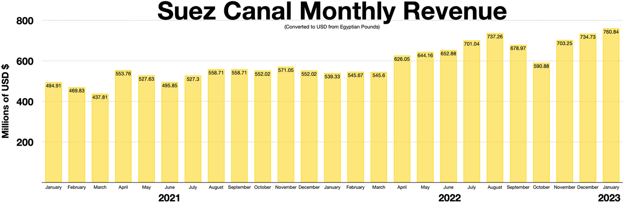
Economic importance and uses
The Suez Canal carries a substantial share of world seaborne trade, including container ships, bulk carriers and tankers carrying crude oil and refined products. By shortening routes between Europe and Asia, it lowers voyage times and fuel consumption and reduces shipping costs. Tolls are an important source of revenue for Egypt, and the canal’s operability has direct effects on global supply chains, energy markets and maritime insurance.
Incidents, environment and strategic notes
The canal’s strategic location has made it a focal point in times of conflict and a bottleneck in times of heavy traffic. Notable disruptions in modern times include wartime closures and major accidents that temporarily halted transits. Environmental considerations—such as the transfer of marine species between the two seas and local coastal impacts—have become part of contemporary management discussions. Security, salvage capability and traffic control remain central to keeping the waterway reliable for global commerce.
Related pages and names
- Arabic name: Qanā al-Suways
- French name: Le Canal de Suez
- Canal (general concept)
- Egypt (country)
- Sinai Peninsula
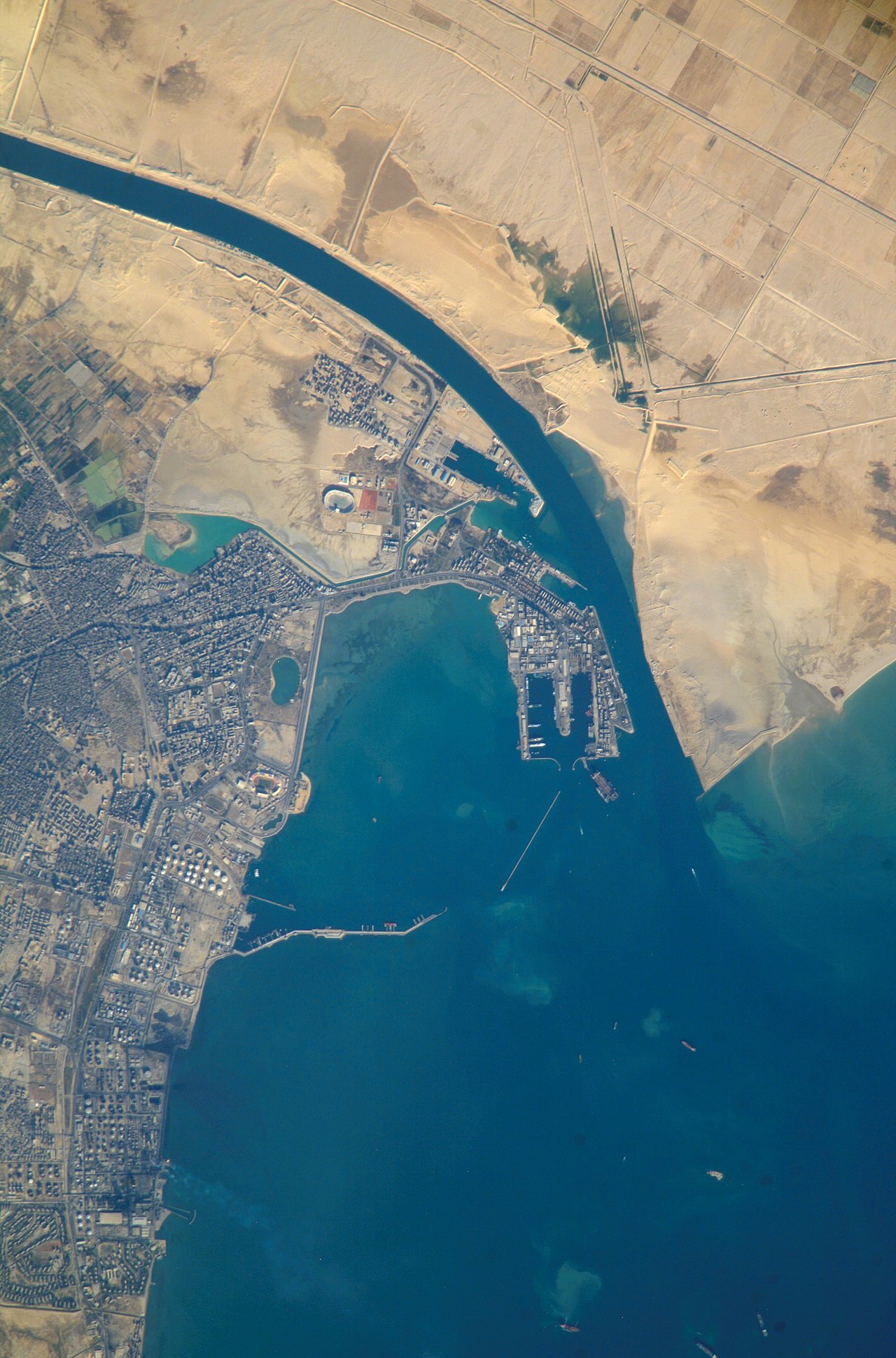
- Port Said (northern terminus)
- Mediterranean Sea
- Suez (southern terminus)
- Red Sea
- The 19th-century French company involved
- Construction and engineering organization
- Work began in 1859
- Official opening in 1869
- Europe (maritime links)
- Asia (maritime links)
- Route alternative: sailing around Africa


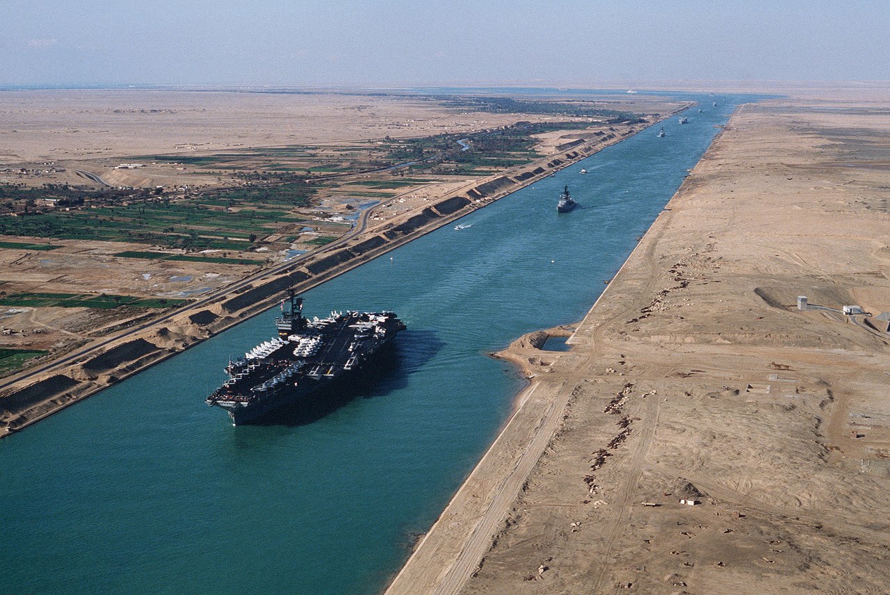
Largest passage profile for ships
Ships up to Suezmax can navigate the canal. Larger ships fall into the category Capesize (as of 2008) and have to choose a route from southern Asia to Europe via Cape Town, around the southern tip of Africa. (as of 2008)
The Panama Canal is more constricting than the Suez Canal in terms of ship profile. (As of 2008)
The Suez Canal was deepened in 2009/2010; since then, this expansion has enabled ships with a draught of up to 20.1 m to pass through. There is no evidence that water level changes due to tides play a role near the transitions to the seas.
Global melting of ice in the course of climate warming leads us to expect an increasing height of sea levels and thus of the water level in the Suez Canal. Waves and currents generated by shipping traffic tend to cause downward migration, and collisions with a ship's hull cause material on the banks to slide and shift at certain points. Echosounder surveys can investigate changes in channel depth, suction dredging can remove material from the bottom.
Crossings
For the land traffic crossing the canal there are some ferries, a road bridge, a railway bridge (over both arms, see below) and a road tunnel. There are or were concepts for the construction of further tunnels.
Listed from north to south:
- via the "West Arm" (not a functional part of the canal, but part of the Suez Canal Area) in/near Port Said on the Mediterranean Sea
- Port Said Ferry from Port Said to Port F(o)uad City in the southeast of the waterway
- Al Raswa ferry
- El Nasr Floating Bridge (December 2016. 6 pontoons make a total length of 420 m. Usable for cars).
- via the "East Arm" (functionally the Suez Canal)
- Ferry
--
- Qantara Ferryboat Ferry
- Qantara Cars Ferryboat Ferry
- Suez Canal Bridge (Peace, Al Salam, Mubaraj ...) Road bridge with 70 m clear height allows for ships up to 68 m high (opened 2001)
--
Bypass two-arm
--
One-armed
--
Two-armed
--
Water cross connection, still two-armed
--
- unnamed ferry just north of the railway bridge
- El Ferdan railway bridges over the West Arm (2001, single-track swing bridge, out of service since 2014 with the construction of the New Suez Canal (= East Arm)) and New El Ferdan over the East Arm (as of 2017: not yet constructed, decision to build a new double-track bridge and against a tunnel).
--
Water cross connection, still two-branch, at the water T east of the East Branch: New Suez Canal Headquarters
--
- in Ismailia
- via west arm: Nemra 6 Ferry, ferry at road 6 Ismailia
- over Ostarm road bridge
--
Timsahsee communicates west of the West Arm
2 water cross connections between 2 arms
Bitter Lakes
--
In/near the city of Suez:
- Ahmed Hamdi Tunnel of Road 50 (opened in 1981, leaks repaired in 1991, reopened in 1992)
- Ferry The Ferry Road height
Questions and answers
Q: Where is the Suez Canal located?
A: The Suez Canal is located in Egypt, west of the Sinai Peninsula.
Q: How long is the Suez Canal?
A: The Suez Canal is 163 km (101 miles) long.
Q: What is the width of the Suez Canal at its narrowest point?
A: The Suez Canal is 200 m (656 ft) wide at its narrowest point.
Q: Who built the Suez Canal?
A: The Suez Canal was built by a French company.
Q: When was the construction of the Suez Canal started and completed?
A: The construction of the Suez Canal was started in 1859 and finished in 1869.
Q: What is the purpose of the Suez Canal?
A: The purpose of the Suez Canal is to allow ships to travel between Europe and Asia without having to go the way around Africa, saving time and fuel.
Q: For whom was the Suez Canal built?
A: The Suez Canal was built for Europeans to go to and from the Indian Ocean.
Related articles
Author
AlegsaOnline.com Suez Canal: history, route, and global significance Leandro Alegsa
URL: https://en.alegsaonline.com/art/94609