Stuttgart — capital of Baden-Württemberg and Germany's automotive heart
Overview of Stuttgart: location on the Neckar, administrative role, economy (Mercedes‑Benz and Porsche), culture, history, climate and transport in Germany's sixth‑largest city.
Overview
Stuttgart is a major city in Germany and serves as the capital of the state of Baden‑Württemberg. It is also the seat of the Administrative District of Stuttgart and functions as the centre of a larger metropolitan area. With a population in the mid‑hundreds of thousands, Stuttgart ranks among the six largest cities in the country and anchors the economically important Stuttgart Region.
Image gallery
2 Images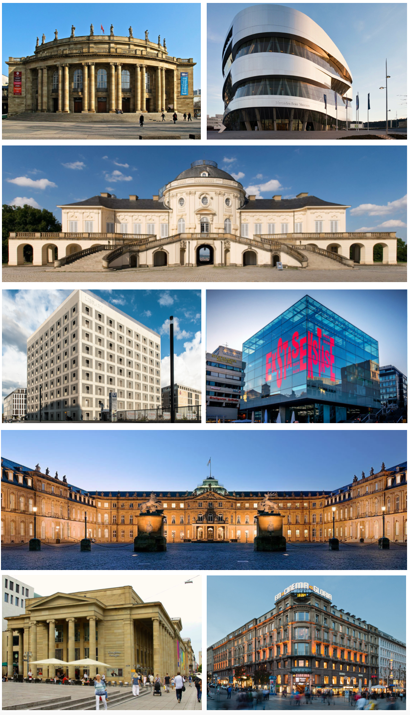

Geography and urban structure
Built in a bowl of hills through which the Neckar river flows, Stuttgart is notable for its varied topography. Vineyards, parks and forested slopes remain within and around the urban area, giving the city a distinctive mix of green spaces and dense neighbourhoods. Administratively the city is divided into 23 districts; local life is organised around these subdivisions and a network of tram, S‑Bahn and U‑Bahn lines.
History and name
The place name traces back to an Old High German word meaning a stud farm — a clue to its origins as a centre for horse breeding in the early Middle Ages. Over centuries Stuttgart expanded from a market town into a regional capital. Industrialisation in the 19th and early 20th centuries accelerated growth, and the city was substantially rebuilt after severe damage in the Second World War. For contemporary civic information see official Stuttgart resources.
Economy and industry
Stuttgart is internationally recognised as a hub for engineering and automotive manufacturing. It is home to two of the most famous car makers, Mercedes‑Benz and Porsche, whose factories, headquarters and museums are major employers and tourist draws. The broader metropolitan area supports suppliers, research institutions and a dense cluster of high‑tech firms. The city's role in manufacturing and innovation helps explain its central economic place within the region.
Culture, landmarks and public life
Stuttgart has a rich cultural scene that includes opera, museums and public festivals. Important sites and institutions include:
- Schlossplatz and the Schlossgarten — the historic central square and gardens;
- State Opera and major concert venues;
- Staatsgalerie — a museum with modern and classical collections;
- Mercedes‑Benz Museum and Porsche Museum showcasing the region's automotive heritage.
These attractions sit alongside frequent markets, a lively food scene that features Swabian cuisine and many neighbourhood festivals organised at the district level; the municipal layout of 23 city districts encourages local cultural activity.
Climate, transport and notable facts
Stuttgart has an oceanic climate with moderate temperature variation and enough precipitation spread through the year to support its vineyards and parkland; climatologists classify it as Cfb in the Köppen system (climate reference). The city is served by a regional airport, an extensive rail and tram network and good road connections. Its combination of green hills, industrial history and cultural institutions makes Stuttgart a distinct urban centre within southern Germany.


Geographical position
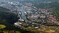
Stuttgart (in the local Swabian dialect Schduagerd) is located in the centre of the state of Baden-Württemberg. The core city is located "between forest and vineyards" in the "Stuttgart basin", a basin through which the Nesenbach, flowing north-eastwards towards the Neckar, and its tributary streams, especially the Vogelsangbach, flow. The city districts extend in the north to the Neckar basin, in the west to the Glemswald and the Gäu, in the east to the foothills of the Schurwald and in the south to the Filder plain and the foothills of the Schönbuch. In the southeast, the Neckar flows into the city area at the Hedelfingen/Obertürkheim districts coming from Esslingen am Neckar and leaves it again in the Mühlhausen district in the northeast.
The city area extends - unusually for large cities - over an altitude difference of almost 350 m. The altitude ranges from 207 m above sea level at the Neckar lock Hofen to 549 m on the Bernhartshöhe near the motorway junction Stuttgart. The most prominent elevations include the Birkenkopf (511 m) at the edge of the valley basin, the Württemberg (411 m) above the Neckar valley and the Grüne Heiner (395 m) at the northwestern city limits.
· 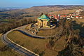
The Württemberg with burial chapel
· 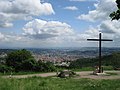
View on Stuttgart from the 511 m high Birkenkopf
· 
Neckar near Hedelfingen and Obertürkheim
· 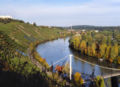
Vineyards in steep slopes at Cannstatter Zuckerle
· 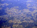
Aerial view from 2018
See also: Historical Stuttgart city maps
Spatial planning
The city of Stuttgart is one of 14 regional centres in Baden-Württemberg. It is the main centre of the Stuttgart region, which in turn, with the city of Stuttgart and its five districts, is home to a total of 2.67 million inhabitants.
The following medium-sized centres are located in the area of the Stuttgart regional centre (Stuttgart Region):
Backnang, Bietigheim-Bissingen/Besigheim, Böblingen/Sindelfingen, Esslingen am Neckar, Geislingen an der Steige, Göppingen, Herrenberg, Kirchheim unter Teck, Leonberg, Ludwigsburg/Kornwestheim, Nürtingen, Schorndorf, Vaihingen an der Enz and Waiblingen/Fellbach.
The city of Stuttgart acts as a middle centre for the cities of Leinfelden-Echterdingen and Filderstadt - both located in the district of Esslingen - as well as for the cities of Ditzingen, Gerlingen and Korntal-Münchingen - all three located in the district of Ludwigsburg.
The city of Stuttgart is the centre of the Stuttgart Metropolitan Region and one of the three major centres within it. The Stuttgart Metropolitan Region is home to a total of 5.3 million inhabitants.
Neighboring communities
The following cities and municipalities border the state capital Stuttgart. They are named clockwise, starting in the northeast:
Fellbach, Kernen im Remstal (all Rems-Murr district), Esslingen am Neckar, Ostfildern, Neuhausen auf den Fildern, Filderstadt and Leinfelden-Echterdingen (all Esslingen district), Sindelfingen and Leonberg (Böblingen district) as well as Gerlingen, Ditzingen, Korntal-Münchingen, Möglingen, Kornwestheim and Remseck am Neckar (all Ludwigsburg district). Thus, four of the five districts of the Stuttgart Region border on the city district of Stuttgart.
City breakdown
→ Main article: List of boroughs and districts of Stuttgart and List of places in Stuttgart.
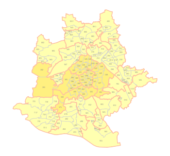
The city area of the state capital Stuttgart is administratively divided into five "inner" and 18 "outer" city districts. The city districts have a district advisory council and a district head, who is only active on an honorary basis in the inner city districts.
The city boroughs are further divided into city districts. The number of city districts was increased by the amendment of the main statutes on 1 July 2007 and 1 January 2009. Since then, the urban area of Stuttgart consists of 23 city districts and 152 city parts (city districts on the city map are clickable).
|
|
The land division of the 20,735 ha is shown in the following diagram:
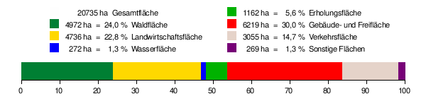
According to data from the State Statistical Office, as of 2015.
Climate
Due to the location in the wide Stuttgart basin and the dense development, there is a comparatively warm and sometimes sultry climate. The mountain ranges of the Black Forest, Swabian Alb, Schurwald and the Swabian-Franconian Forest additionally shade the entire region from winds. Because of this, even viticulture is possible on the slopes of Stuttgart. With 423 hectares of vineyards, viticulture in Stuttgart covers a good two percent of the city's area.
The annual mean temperature in Stuttgart is 9.3 °C (Schnarrenberg weather station), in the city centre and in the Neckar valley 10.6 °C and on the Filder hills at the airport 8.5 °C. In winter, the city centre, which is located in the valley basin, remains mostly free of snow and ice. Strong "felt" winds are also rather rare in the inner city due to the dense development. In order to still have enough fresh air in the basin despite the inversion weather conditions that occur time and again, many places on the slopes - especially in Stuttgart-West - are undeveloped and serve as fresh air corridors. The Rot- und Schwarzwildpark forest on the heights in the west also serves as a source of fresh air for the lower lying city centre. In order to improve air pollution control and reduce particulate matter levels, a ban on the passage of trucks was enacted in 2005, but had to be lifted again in connection with the introduction of the particulate matter ordinance on March 1, 2008. A new ban on trucks passing through has been in force since March 2010.
The leeward location of the Stuttgart region is the reason why it is one of the regions in Germany with low precipitation. The clouds rain down on the Swabian Alb and the Black Forest, so that only relatively dry air reaches Stuttgart. Rising population figures led to a shortage of drinking water at the beginning of the 20th century, whereupon the first long-distance pipeline from the Donauried across the Alb went into operation in 1917 (Landeswasserversorgung). This was followed in 1959 by the Lake Constance water supply.
| Stuttgart | ||||||||||||||||||||||||||||||||||||||||||||||||
| Climate diagram | ||||||||||||||||||||||||||||||||||||||||||||||||
| ||||||||||||||||||||||||||||||||||||||||||||||||
| Monthly average temperatures and precipitation for Stuttgart
Source: wetterdienst.de, data: 2015-2020; wetterkontor.de;[2]. | |||||||||||||||||||||||||||||||||||||||||||||||||||||||||||||||||||||||||||||||||||||||||||||||||||||||||||||||||||||||||||||||||||||||||||||||||||||||||||||||||||||||||||||||||||||||||||||||||||||||||||||||||||||||||||||||||||||||||||||||||||||||||||||||||||||||||||
Nature
The following nature conservation areas are located on the territory of the state capital Stuttgart: According to the protected area statistics of the Baden-Württemberg State Institute for the Environment, Measurements and Nature Conservation (LUBW), 1353.19 hectares of the city's area are under nature conservation, which is 6.53 percent.
- Büsnauer Wiesental: 27.8 ha; district of Vaihingen
- Oak grove: 34.2 ha; boundaries Riedenberg and Sillenbuch
- Greutterwald: 151.3 ha (of which 149.4 ha in Stuttgart); districts of Weilimdorf, Zuffenhausen, Feuerbach and Korntal (district of Ludwigsburg)
- Häslachwald: 53.6 ha (of which 45 ha in Stuttgart); Plieningen and Kemnat districts (Esslingen district)
- Red deer park near Stuttgart (red and wild boar park): 830.5 ha; Stuttgart and Vaihingen districts
- Lower Feuerbach valley with slope forests and surroundings: 47.5 ha; Mühlhausen and Zuffenhausen districts
- Weidach and Zettach forest: 226.0 ha; parishes of Möhringen and Plieningen
Stuttgart is nationally known for its yellow-headed Amazon population, which is the only one in the wild outside of the Americas.


Population
Population development
→ Main article: Population development of Stuttgart and Stuttgart city statistics
See also: Demography of Germany
Stuttgart had more than 100,000 inhabitants for the first time in 1875, becoming the first major city in what is now the state of Baden-Württemberg. In 1905 the city had 250,000 inhabitants, by 1950 this number had doubled to 500,000. In 1962 the population reached its historic high of 640,560. In terms of population, the city is the sixth largest city in Germany and (after Munich and ahead of Nuremberg) the second largest city in southern Germany. In its own federal state, Stuttgart is some distance ahead of Karlsruhe and Mannheim.
The average age at the end of 2016 was 41.8 years.
According to the 2011 census, the proportion of the population with a migration background was 38.6 %. Stuttgart had the second highest proportion of all major German cities - after Frankfurt am Main with 44.2 % and ahead of Nuremberg with 36.4 %. The proportion of foreigners was 25.2 % in 2016. 44 % of Stuttgart's inhabitants had a migration background.
As of December 31, 2018, the City of Stuttgart's population register recorded 614,365 residents with primary residency and 6,926 citizens with secondary residency.
In 2018, a total of 6534 children were born (2017: 6725); this was 239 births lower than the peak in 2016. The number of births increased significantly between 2012 and 2016 and has been declining since then.
The number of annual deaths in Stuttgart has fluctuated between 5000 and 5700 for two decades, with 5507 people dying in 2017 and 5471 in 2018. The number of births exceeded the number of deaths by 1063 in 2018.
Housing situation
The average existing rent in Stuttgart is €9.92 per square metre, higher than Frankfurt am Main (€8.87) and lower than Munich (€10.22) (as at the end of 2017).
The rent level in the current rent index rose by 7.2 per cent between 2016 and 2018 to €9.60 per square metre. The average asking rent for apartments offered on the market climbed to 14.15 euros per square metre in the first half of 2018. For first-time lettings in new builds, the average asking rent was €17 per square metre, while for re-letting, the average asking rent was €13.90 per square metre.
Language
Stuttgart belongs to the Lower Swabian language area, a dialect group spoken in the central and southeastern area of Baden-Württemberg. Linguistically, Swabian belongs to the Alemannic dialects and thus to Upper German. It has separated from the other Alemannic dialects through the complete implementation of New High German diphthongization.

Questions and answers
Q: Where is Stuttgart located?
A: Stuttgart is located in Germany.
Q: What is the population of Stuttgart as of December 2011?
A: As of December 2011, the population of Stuttgart is 613,392.
Q: What is the capital of the state of Baden-Württemberg and the Administrative District of Stuttgart?
A: The capital of the state of Baden-Württemberg and the Administrative District of Stuttgart is Stuttgart.
Q: What river is Stuttgart located on?
A: Stuttgart is located on the river Neckar.
Q: How many city districts is Stuttgart divided into?
A: Stuttgart is divided into 23 city districts.
Q: What are the names of the two car manufacturers that have their headquarters in Stuttgart?
A: The two car manufacturers that have their headquarters in Stuttgart are Mercedes Benz and Porsche.
Q: What is the climate classification of Stuttgart?
A: The climate classification of Stuttgart is oceanic (Cfb in the Koeppen climate classification).
Related articles
Author
AlegsaOnline.com Stuttgart — capital of Baden-Württemberg and Germany's automotive heart Leandro Alegsa
URL: https://en.alegsaonline.com/art/94421
Sources
- statistik.baden-wuerttemberg.de : "Alle politisch selbständigen Gemeinden mit ausgewählten Merkmalen am 31.12.2018 (4. Quartal)"
- destatis.de : destatis.de/DE/ZahlenFakten/LaenderRegionen/Regionales/Gemeindeverzeichnis/Administrativ/…
- destatis.de : "Gemeinden in Deutschland nach Fläche, Bevölkerung und Postleitzahl am 30.09.2016"
- statistik.baden-wuerttemberg.de : statistik.baden-wuerttemberg.de
- deutsche-metropolregionen.org : "(in German)[[Category:Articles with German-language sources (de)]] Stuttgart"